![](/images/other/stat-length.png)
![Tour Wandern Finhaut - L'alpage de Fenestral - Photo](https://media.geolcdn.com/t/1900/400/ext.pjpeg?maxdim=2&url=https%3A%2F%2Fstatic1.geolcdn.com%2Fsiteimages%2Fupload%2Ffiles%2F1553511878bg_sport_marche.png)
L'alpage de Fenestral
PatCoria
Benutzer
![Länge](/images/other/stat-length.png)
Länge
5,2 km
![Maximale Höhe](https://static1.geolcdn.com/siteimages/upload/files/1508320355ic_sort_altitude_max_24dp.png)
Maximale Höhe
1906 m
![Positive Höhendifferenz](https://static1.geolcdn.com/siteimages/upload/files/1508320355ic_sort_den_pos_24dp.png)
Positive Höhendifferenz
503 m
![Km-Effort](/images/other/stat-length.png)
Km-Effort
12 km
![Min. Höhe](https://static1.geolcdn.com/siteimages/upload/files/1508320355ic_sort_altitude_min_24dp.png)
Min. Höhe
1442 m
![Negative Höhendifferenz](https://static1.geolcdn.com/siteimages/upload/files/1508320355ic_sort_den_neg_24dp.png)
Negative Höhendifferenz
503 m
![Boucle](https://static1.geolcdn.com/siteimages/upload/files/16400158638029165_repeat_loop_refresh_sync_direction_icon.png)
Boucle
Ja
Erstellungsdatum :
2015-05-18 00:00:00.0
Letzte Änderung :
2015-05-18 00:00:00.0
![Wandern](https://static1.geolcdn.com/sitytour/trail-icons/101.png)
3h00
Schwierigkeit : Einfach
![Scannen Sie diesen QR-Code, um die Tour in der SityTrail-Anwendung zu öffnen](https://capi.geolives.com/qq0zvz2zws4bq2lad0pu/sitytour/trails/422573/qr.png?size=200)
Kostenlosegpshiking-Anwendung
Über SityTrail
Tour Wandern von 5,2 km verfügbar auf Wallis, Sankt Moritz, Finhaut. Diese Tour wird von PatCoria vorgeschlagen.
Beschreibung
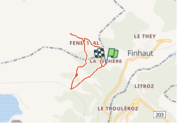
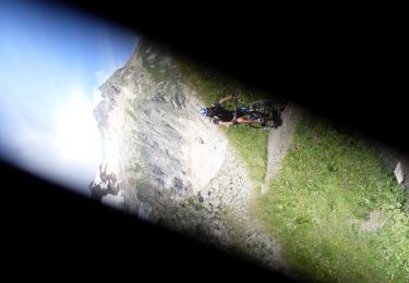
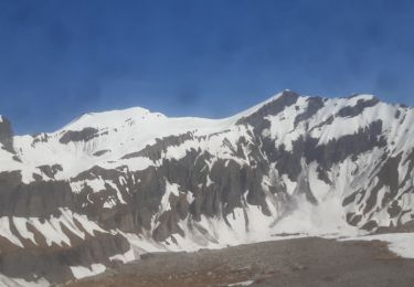
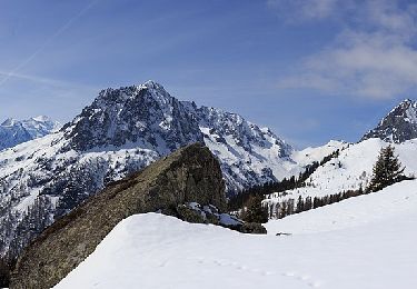
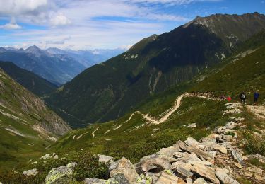
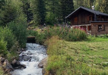
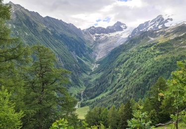
Départ du hameau "La Léchère" (1441 m) sur la route du barrage d'Emosson. Vues sur la pointe de la Rionde et la dent de Fensestral. Au Plan des Marais, lieu paradisiaque pour les amoureux de solitude et de nature sauvage.
Ort
Land:
Switzerland
Region :
Wallis
Abteilung/Provinz :
Sankt Moritz
Kommune :
Finhaut
Standort:
Unknown
Gehen Sie:(Dec)
Gehen Sie:(UTM)
342624 ; 5104945 (32T) N.
Kommentare
Touren in der Umgebung
![Tour Mountainbike Trient - Tour du Mont Blanc VTT - La Forclaz à La Fouly - Photo](https://media.geolcdn.com/t/375/260/ext.jpg?maxdim=2&url=https%3A%2F%2Fservices.sitytrail.com%2FGeolivesWS%2FDownloadMedia.ashx%3FTrailID%3D103669%26Media%3D6144_3.jpg)
![Mountainbike Mountainbike](https://static1.geolcdn.com/sitytour/trail-icons/202.png)
Tour du Mont Blanc VTT - La Forclaz à La Fouly
Mountainbike
Schwierig
(1)
Trient,
Wallis,
Martinach,
Switzerland
![](/images/other/stat-length.png)
31 km | 52 km-effort
3h 49min
![](https://static1.geolcdn.com/siteimages/upload/files/16400158638029165_repeat_loop_refresh_sync_direction_icon.png)
Nein
![Tour Skiwanderen Finhaut - pointe de la terrasse - Photo](https://media.geolcdn.com/t/375/260/d4e5c913-45a8-46a0-b8c1-07b0c700d709.jpg&format=jpg&maxdim=2)
![Skiwanderen Skiwanderen](https://static1.geolcdn.com/sitytour/trail-icons/503.png)
pointe de la terrasse
Skiwanderen
Sehr leicht
Finhaut,
Wallis,
Sankt Moritz,
Switzerland
![](/images/other/stat-length.png)
8,7 km | 19 km-effort
3h 14min
![](https://static1.geolcdn.com/siteimages/upload/files/16400158638029165_repeat_loop_refresh_sync_direction_icon.png)
Nein
![Tour Zu Fuß Vallorcine - Chalet de Loriaz - Photo](https://media.geolcdn.com/t/375/260/c078a892-64c2-440e-a24a-1e74f82d7a2b.jpeg&format=jpg&maxdim=2)
![Zu Fuß Zu Fuß](https://static1.geolcdn.com/sitytour/trail-icons/100.png)
Chalet de Loriaz
Zu Fuß
Medium
Vallorcine,
Auvergne-Rhone-Alpen,
Hochsavoyen,
France
![](/images/other/stat-length.png)
13,6 km | 26 km-effort
5h 55min
![](https://static1.geolcdn.com/siteimages/upload/files/16400158638029165_repeat_loop_refresh_sync_direction_icon.png)
Ja
![Tour Zu Fuß Trient - Sentier des Alpages - Photo](https://media.geolcdn.com/t/375/260/2d94fac1-b61d-463c-b3fe-e4184ed18b6d.jpeg&format=jpg&maxdim=2)
![Zu Fuß Zu Fuß](https://static1.geolcdn.com/sitytour/trail-icons/100.png)
Sentier des Alpages
Zu Fuß
Medium
Trient,
Wallis,
Martinach,
Switzerland
![](/images/other/stat-length.png)
11,4 km | 24 km-effort
5h 31min
![](https://static1.geolcdn.com/siteimages/upload/files/16400158638029165_repeat_loop_refresh_sync_direction_icon.png)
Ja
![Tour Wandern Trient - CMX ZRMT Étape 1 col de la Forcez- Champex - Photo](https://media.geolcdn.com/t/375/260/ext.jpg?maxdim=2&url=https%3A%2F%2Fservices.sitytrail.com%2FGeolivesWS%2FDownloadMedia.ashx%3FTrailID%3D635926%26Media%3Dfix__20160913113155.jpg)
![Wandern Wandern](https://static1.geolcdn.com/sitytour/trail-icons/101.png)
CMX ZRMT Étape 1 col de la Forcez- Champex
Wandern
Einfach
Trient,
Wallis,
Martinach,
Switzerland
![](/images/other/stat-length.png)
13,8 km | 24 km-effort
4h 35min
![](https://static1.geolcdn.com/siteimages/upload/files/16400158638029165_repeat_loop_refresh_sync_direction_icon.png)
Nein
![Tour Wandern Trient - TMB J2 TRIENT - CHAMPEX - Photo](https://media.geolcdn.com/t/375/260/ext.jpg?maxdim=2&url=https%3A%2F%2Fservices.sitytrail.com%2FGeolivesWS%2FDownloadMedia.ashx%3FTrailID%3D594960%26Media%3Dfix__20160704115027.jpg)
![Wandern Wandern](https://static1.geolcdn.com/sitytour/trail-icons/101.png)
TMB J2 TRIENT - CHAMPEX
Wandern
Schwierig
Trient,
Wallis,
Martinach,
Switzerland
![](/images/other/stat-length.png)
15 km | 34 km-effort
6h 59min
![](https://static1.geolcdn.com/siteimages/upload/files/16400158638029165_repeat_loop_refresh_sync_direction_icon.png)
Nein
![Tour Wandern Trient - TMB day 6 - Photo](https://media.geolcdn.com/t/375/260/ext.jpg?maxdim=2&url=https%3A%2F%2Fservices.sitytrail.com%2FGeolivesWS%2FDownloadMedia.ashx%3FTrailID%3D477617%26Media%3Dfix__20150926142604.jpg)
![Wandern Wandern](https://static1.geolcdn.com/sitytour/trail-icons/101.png)
TMB day 6
Wandern
Medium
Trient,
Wallis,
Martinach,
Switzerland
![](/images/other/stat-length.png)
10,9 km | 22 km-effort
4h 30min
![](https://static1.geolcdn.com/siteimages/upload/files/16400158638029165_repeat_loop_refresh_sync_direction_icon.png)
Nein
![Tour Wandern Trient - GTMB ETAPE 3Trient Champex - Photo](https://media.geolcdn.com/t/375/260/26b16715-c4ce-4fef-8c8a-c237ba9329e4.jpg&format=jpg&maxdim=2)
![Wandern Wandern](https://static1.geolcdn.com/sitytour/trail-icons/101.png)
GTMB ETAPE 3Trient Champex
Wandern
Sehr schwierig
Trient,
Wallis,
Martinach,
Switzerland
![](/images/other/stat-length.png)
12,8 km | 31 km-effort
8h 25min
![](https://static1.geolcdn.com/siteimages/upload/files/16400158638029165_repeat_loop_refresh_sync_direction_icon.png)
Nein
![Tour Wandern Trient - TMB 09 - Trient -> Tréléchamp - Photo](https://media.geolcdn.com/t/375/260/26cc7077-53f6-4efe-aee1-a461495a60e6.jpg&format=jpg&maxdim=2)
![Wandern Wandern](https://static1.geolcdn.com/sitytour/trail-icons/101.png)
TMB 09 - Trient -> Tréléchamp
Wandern
Schwierig
Trient,
Wallis,
Martinach,
Switzerland
![](/images/other/stat-length.png)
13,7 km | 27 km-effort
6h 46min
![](https://static1.geolcdn.com/siteimages/upload/files/16400158638029165_repeat_loop_refresh_sync_direction_icon.png)
Nein