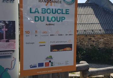
![](/images/other/stat-length.png)
![Tour Nordic Walking Saint-Pierre-de-Nogaret - SityTrail - Le Brouillet - Cascade du Saltou - Photo](https://media.geolcdn.com/t/1900/400/9822abe2-4c8b-4b7c-84d0-1c52daa9f381.jpg&format=pjpeg&maxdim=2)
SityTrail - Le Brouillet - Cascade du Saltou
mdauzat
Benutzer
![Länge](/images/other/stat-length.png)
![Maximale Höhe](https://static1.geolcdn.com/siteimages/upload/files/1508320355ic_sort_altitude_max_24dp.png)
![Positive Höhendifferenz](https://static1.geolcdn.com/siteimages/upload/files/1508320355ic_sort_den_pos_24dp.png)
![Km-Effort](/images/other/stat-length.png)
![Min. Höhe](https://static1.geolcdn.com/siteimages/upload/files/1508320355ic_sort_altitude_min_24dp.png)
![Negative Höhendifferenz](https://static1.geolcdn.com/siteimages/upload/files/1508320355ic_sort_den_neg_24dp.png)
![Boucle](https://static1.geolcdn.com/siteimages/upload/files/16400158638029165_repeat_loop_refresh_sync_direction_icon.png)
![Nordic Walking](https://static1.geolcdn.com/sitytour/trail-icons/102.png)
2h50
Schwierigkeit : Medium
![Scannen Sie diesen QR-Code, um die Tour in der SityTrail-Anwendung zu öffnen](https://capi.geolives.com/qq0zvz2zws4bq2lad0pu/sitytour/trails/4202512/qr.png?size=200)
Kostenlosegpshiking-Anwendung
Über SityTrail
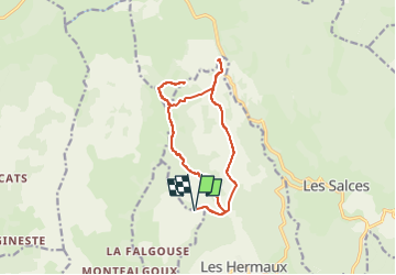
Tour Nordic Walking von 14,2 km verfügbar auf Okzitanien, Lozère, Saint-Pierre-de-Nogaret. Diese Tour wird von mdauzat vorgeschlagen.
Beschreibung
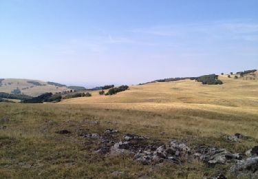
À proximité du Col de Bonnecombe se trouve une cascade moins connue que la Cascade du Déroc mais tout aussi charmante, bien que des plus modestes : la Cascade du Saltou. Cette jolie cascade est située sur le ruisseau du Pesquio. L’accès se fait à pied par un chemin en bordure de la route menant du Col de Bonnecombe vers Les Hermaux. La Cascade du Saltou est formée par un ruisseau qui débute du Col de Bonnecombe pour former ensuite une chute d’eau dégringolant le long de remarquables orgues basaltiques. Le cadre est d’autant plus pittoresque que la cascade est parfaitement invisible des alentours, et il faut se trouver à ses pieds pour profiter du spectacle.
Le circuit passe à proximité du Lac de Bonnecombe dont on peut inclure la visite dans la boucle.
Ort
Kommentare
Touren in der Umgebung
![Tour Nordic Walking Les Salces - Boucle du Loup depuis les Salces - Photo](https://media.geolcdn.com/t/375/260/84adfcce-71e7-4ab8-8fc1-9a84d109fca5.jpg&format=jpg&maxdim=2)
![Nordic Walking Nordic Walking](https://static1.geolcdn.com/sitytour/trail-icons/102.png)
Nordic Walking
![](/images/other/stat-length.png)
![](https://static1.geolcdn.com/siteimages/upload/files/16400158638029165_repeat_loop_refresh_sync_direction_icon.png)
![Tour Nordic Walking Trélans - Trélans Aubrac - Croix du Pal - Photo](https://media.geolcdn.com/t/375/260/693ad15b-186e-4874-89e5-6809bb1e1e64.jpg&format=jpg&maxdim=2)
![Nordic Walking Nordic Walking](https://static1.geolcdn.com/sitytour/trail-icons/102.png)
Nordic Walking
![](/images/other/stat-length.png)
![](https://static1.geolcdn.com/siteimages/upload/files/16400158638029165_repeat_loop_refresh_sync_direction_icon.png)
![Tour Wandern Trélans - Mon chemin de St Guilhem étape 4 - Photo](https://media.geolcdn.com/t/375/260/9dac2029-d636-4d16-9493-ea0b171f0b7e.jpg&format=jpg&maxdim=2)
![Wandern Wandern](https://static1.geolcdn.com/sitytour/trail-icons/101.png)
Wandern
![](/images/other/stat-length.png)
![](https://static1.geolcdn.com/siteimages/upload/files/16400158638029165_repeat_loop_refresh_sync_direction_icon.png)
![Tour Wandern Trélans - Étape 4 Saint Gilhem - Photo](https://media.geolcdn.com/t/375/260/0a97a0ec-c8ee-4fcf-a11b-a8c4289b3e19.jpg&format=jpg&maxdim=2)
![Wandern Wandern](https://static1.geolcdn.com/sitytour/trail-icons/101.png)
Wandern
![](/images/other/stat-length.png)
![](https://static1.geolcdn.com/siteimages/upload/files/16400158638029165_repeat_loop_refresh_sync_direction_icon.png)
![Tour Wandern Les Hermaux - Rando Lozère.. Rajas..Malailhebiai. - Photo](https://media.geolcdn.com/t/375/260/d7d4238f-1d05-4619-84e8-be25d5ba8938.jpg&format=jpg&maxdim=2)
![Wandern Wandern](https://static1.geolcdn.com/sitytour/trail-icons/101.png)
Wandern
![](/images/other/stat-length.png)
![](https://static1.geolcdn.com/siteimages/upload/files/16400158638029165_repeat_loop_refresh_sync_direction_icon.png)
![Tour Wandern Les Hermaux - Lou saltou - Photo](https://media.geolcdn.com/t/375/260/5ac28f7d-bfae-45d7-a4b8-1fed8d14ded9.jpg&format=jpg&maxdim=2)
![Wandern Wandern](https://static1.geolcdn.com/sitytour/trail-icons/101.png)
Wandern
![](/images/other/stat-length.png)
![](https://static1.geolcdn.com/siteimages/upload/files/16400158638029165_repeat_loop_refresh_sync_direction_icon.png)
![Tour Wandern Les Salces - la boucle du loup - Photo](https://media.geolcdn.com/t/375/260/96ff1e81-ee0b-4855-a29a-644650d1d720.jpg&format=jpg&maxdim=2)
![Wandern Wandern](https://static1.geolcdn.com/sitytour/trail-icons/101.png)
Wandern
![](/images/other/stat-length.png)
![](https://static1.geolcdn.com/siteimages/upload/files/16400158638029165_repeat_loop_refresh_sync_direction_icon.png)
![Tour Wandern Les Hermaux - Signal de Mailhebiau - Photo](https://media.geolcdn.com/t/375/260/ext.jpg?maxdim=2&url=https%3A%2F%2Fservices.sitytrail.com%2FGeolivesWS%2FDownloadMedia.ashx%3FTrailID%3D152984%26Media%3D20120909121339.jpg)
![Wandern Wandern](https://static1.geolcdn.com/sitytour/trail-icons/101.png)
Wandern
![](/images/other/stat-length.png)
![](https://static1.geolcdn.com/siteimages/upload/files/16400158638029165_repeat_loop_refresh_sync_direction_icon.png)
![Tour Wandern Trélans - Les plagnes à Saint Chely l'aubrac - Photo](https://media.geolcdn.com/t/375/260/20046715-4144-406f-96f7-d9ec6ecee00d.jpg&format=jpg&maxdim=2)
![Wandern Wandern](https://static1.geolcdn.com/sitytour/trail-icons/101.png)
Wandern
![](/images/other/stat-length.png)
![](https://static1.geolcdn.com/siteimages/upload/files/16400158638029165_repeat_loop_refresh_sync_direction_icon.png)