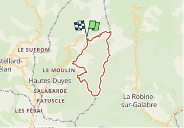
![](/images/other/stat-length.png)
![Tour Wandern Hautes-Duyes - 22/4/18 La Fubie Depuis Auribeau - Photo](https://media.geolcdn.com/t/1900/400/ext.pjpeg?maxdim=2&url=https%3A%2F%2Fstatic1.geolcdn.com%2Fsiteimages%2Fupload%2Ffiles%2F1553511878bg_sport_marche.png)
22/4/18 La Fubie Depuis Auribeau
Geruen
Benutzer
![Länge](/images/other/stat-length.png)
![Maximale Höhe](https://static1.geolcdn.com/siteimages/upload/files/1508320355ic_sort_altitude_max_24dp.png)
![Positive Höhendifferenz](https://static1.geolcdn.com/siteimages/upload/files/1508320355ic_sort_den_pos_24dp.png)
![Km-Effort](/images/other/stat-length.png)
![Min. Höhe](https://static1.geolcdn.com/siteimages/upload/files/1508320355ic_sort_altitude_min_24dp.png)
![Negative Höhendifferenz](https://static1.geolcdn.com/siteimages/upload/files/1508320355ic_sort_den_neg_24dp.png)
![Boucle](https://static1.geolcdn.com/siteimages/upload/files/16400158638029165_repeat_loop_refresh_sync_direction_icon.png)
![Wandern](https://static1.geolcdn.com/sitytour/trail-icons/101.png)
4h31
Schwierigkeit : Sehr schwierig
![Scannen Sie diesen QR-Code, um die Tour in der SityTrail-Anwendung zu öffnen](https://capi.geolives.com/qq0zvz2zws4bq2lad0pu/sitytour/trails/4187814/qr.png?size=200)
Kostenlosegpshiking-Anwendung
Über SityTrail
Tour Wandern von 11,3 km verfügbar auf Provence-Alpes-Côte d'Azur, Alpes-de-Haute-Provence, Hautes-Duyes. Diese Tour wird von Geruen vorgeschlagen.
Beschreibung
Randonnée faite ce jour 13/09/2024.
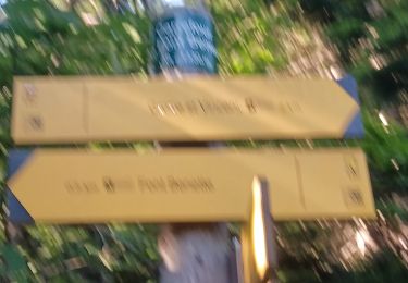
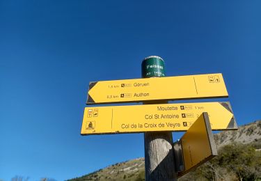
Au col d'Ainac, le Couchebran 4 engins pour construction d'un piste en prévision de coupes de bois. Pas facile de récupérer la trace aux alentours de la côte 1245
La Bouze haute, passer par la lampe moutons patous.
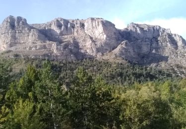
Sinon rando avec belle vue, mais beaucoup de pistes plus ou moins agréables
Ort
Kommentare
Touren in der Umgebung
![Tour Wandern Hautes-Duyes - geruen sentier des chamois - Photo](https://media.geolcdn.com/t/375/260/76e6f18d-9f19-4351-821e-ec84b6202ed5.jpg&format=jpg&maxdim=2)
![Wandern Wandern](https://static1.geolcdn.com/sitytour/trail-icons/101.png)
Wandern
![](/images/other/stat-length.png)
![](https://static1.geolcdn.com/siteimages/upload/files/16400158638029165_repeat_loop_refresh_sync_direction_icon.png)
![Tour Wandern Le Castellard-Mélan - MELAN . Col de Mounis , sommet du Corbeau o l s - Photo](https://media.geolcdn.com/t/375/260/2b656901-381a-4dfe-a9e9-2df9166addba.jpg&format=jpg&maxdim=2)
![Wandern Wandern](https://static1.geolcdn.com/sitytour/trail-icons/101.png)
Wandern
![](/images/other/stat-length.png)
![](https://static1.geolcdn.com/siteimages/upload/files/16400158638029165_repeat_loop_refresh_sync_direction_icon.png)
![Tour Wandern Authon - AUTHON Faissal La Croix de Vey ré Sommet de Chine o - Photo](https://media.geolcdn.com/t/375/260/ext.jpg?maxdim=2&url=https%3A%2F%2Fstatic1.geolcdn.com%2Fsiteimages%2Fupload%2Ffiles%2F1553511878bg_sport_marche.png)
![Wandern Wandern](https://static1.geolcdn.com/sitytour/trail-icons/101.png)
Wandern
![](/images/other/stat-length.png)
![](https://static1.geolcdn.com/siteimages/upload/files/16400158638029165_repeat_loop_refresh_sync_direction_icon.png)
![Tour Wandern La Robine-sur-Galabre - LAMBERT mourre du barri - Photo](https://media.geolcdn.com/t/375/260/ext.jpg?maxdim=2&url=https%3A%2F%2Fstatic1.geolcdn.com%2Fsiteimages%2Fupload%2Ffiles%2F1553511878bg_sport_marche.png)
![Wandern Wandern](https://static1.geolcdn.com/sitytour/trail-icons/101.png)
Wandern
![](/images/other/stat-length.png)
![](https://static1.geolcdn.com/siteimages/upload/files/16400158638029165_repeat_loop_refresh_sync_direction_icon.png)
![Tour Wandern Le Castellard-Mélan - Autour de Fontbelle 18/12/2024 - Photo](https://media.geolcdn.com/t/375/260/69b9121f-8e6a-46ef-affd-f6d0486b57b2.jpg&format=jpg&maxdim=2)
![Wandern Wandern](https://static1.geolcdn.com/sitytour/trail-icons/101.png)
Wandern
![](/images/other/stat-length.png)
![](https://static1.geolcdn.com/siteimages/upload/files/16400158638029165_repeat_loop_refresh_sync_direction_icon.png)
![Tour Wandern Authon - AUTHON. GROTTE. COL DE L AIGUILLE O L - Photo](https://media.geolcdn.com/t/375/260/ddbf7ae4-52a3-4044-bf29-d39533b6071a.jpg&format=jpg&maxdim=2)
![Wandern Wandern](https://static1.geolcdn.com/sitytour/trail-icons/101.png)
Wandern
![](/images/other/stat-length.png)
![](https://static1.geolcdn.com/siteimages/upload/files/16400158638029165_repeat_loop_refresh_sync_direction_icon.png)
![Tour Wandern Authon - AUTHON . FAISSAL .LES MONGES . LA CROIX DE VEYRE O L M - Photo](https://media.geolcdn.com/t/375/260/37444576-1d8a-41eb-baa4-0ccab1de4208.jpg&format=jpg&maxdim=2)
![Wandern Wandern](https://static1.geolcdn.com/sitytour/trail-icons/101.png)
Wandern
![](/images/other/stat-length.png)
![](https://static1.geolcdn.com/siteimages/upload/files/16400158638029165_repeat_loop_refresh_sync_direction_icon.png)
![Tour Wandern Hautes-Duyes - Crête de Géruën descente sud Est - Photo](https://media.geolcdn.com/t/375/260/896db46e-982b-48f6-bf8f-c5ab98c282d0.jpg&format=jpg&maxdim=2)
![Wandern Wandern](https://static1.geolcdn.com/sitytour/trail-icons/101.png)
Wandern
![](/images/other/stat-length.png)
![](https://static1.geolcdn.com/siteimages/upload/files/16400158638029165_repeat_loop_refresh_sync_direction_icon.png)
![Tour Wandern Hautes-Duyes - sommet Geruen et son pas - Photo](https://media.geolcdn.com/t/375/260/3f9beb02-93ed-438f-917d-d2a6ab1524ae.jpg&format=jpg&maxdim=2)
![Wandern Wandern](https://static1.geolcdn.com/sitytour/trail-icons/101.png)
Wandern
![](/images/other/stat-length.png)
![](https://static1.geolcdn.com/siteimages/upload/files/16400158638029165_repeat_loop_refresh_sync_direction_icon.png)