![](/images/other/stat-length.png)
![Tour Fahrrad Saint-Hippolyte-du-Fort - Le Mercou L'Asclier - Photo](https://media.geolcdn.com/t/1900/400/ext.pjpeg?maxdim=2&url=https%3A%2F%2Fstatic1.geolcdn.com%2Fsiteimages%2Fupload%2Ffiles%2F1524743154velo.jpg)
Le Mercou L'Asclier
ARVIEU
Benutzer
![Länge](/images/other/stat-length.png)
Länge
87 km
![Maximale Höhe](https://static1.geolcdn.com/siteimages/upload/files/1508320355ic_sort_altitude_max_24dp.png)
Maximale Höhe
904 m
![Positive Höhendifferenz](https://static1.geolcdn.com/siteimages/upload/files/1508320355ic_sort_den_pos_24dp.png)
Positive Höhendifferenz
1937 m
![Km-Effort](/images/other/stat-length.png)
Km-Effort
112 km
![Min. Höhe](https://static1.geolcdn.com/siteimages/upload/files/1508320355ic_sort_altitude_min_24dp.png)
Min. Höhe
158 m
![Negative Höhendifferenz](https://static1.geolcdn.com/siteimages/upload/files/1508320355ic_sort_den_neg_24dp.png)
Negative Höhendifferenz
1934 m
![Boucle](https://static1.geolcdn.com/siteimages/upload/files/16400158638029165_repeat_loop_refresh_sync_direction_icon.png)
Boucle
Ja
Erstellungsdatum :
2024-09-07 05:31:22.427
Letzte Änderung :
2024-09-07 05:33:31.19
![Fahrrad](https://static1.geolcdn.com/sitytour/trail-icons/200.png)
5h00
Schwierigkeit : Schwierig
![Scannen Sie diesen QR-Code, um die Tour in der SityTrail-Anwendung zu öffnen](https://capi.geolives.com/qq0zvz2zws4bq2lad0pu/sitytour/trails/4181338/qr.png?size=200)
Kostenlosegpshiking-Anwendung
Über SityTrail
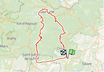
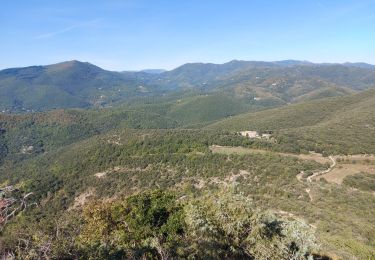
Tour Fahrrad von 87 km verfügbar auf Okzitanien, Gard, Saint-Hippolyte-du-Fort. Diese Tour wird von ARVIEU vorgeschlagen.
Beschreibung
St Hippolyte du Fort Colognac le Mercou l'Estréchure les Plantiers l'Asclier Sumène (ou St Roman de Codières) St Hippolyte du Fort
Ort
Land:
France
Region :
Okzitanien
Abteilung/Provinz :
Gard
Kommune :
Saint-Hippolyte-du-Fort
Standort:
Unknown
Gehen Sie:(Dec)
Gehen Sie:(UTM)
569134 ; 4867580 (31T) N.
Kommentare
Touren in der Umgebung
![Tour Wandern La Cadière-et-Cambo - CAMBO - MONTAGNE DE LA FAGE - 7.6Km - 02h20 - Dénivelé 285 m - Photo](https://media.geolcdn.com/t/375/260/ext.jpg?maxdim=2&url=https%3A%2F%2Fstatic1.geolcdn.com%2Fsiteimages%2Fupload%2Ffiles%2F1553511878bg_sport_marche.png)
![Wandern Wandern](https://static1.geolcdn.com/sitytour/trail-icons/101.png)
CAMBO - MONTAGNE DE LA FAGE - 7.6Km - 02h20 - Dénivelé 285 m
Wandern
Medium
(1)
La Cadière-et-Cambo,
Okzitanien,
Gard,
France
![](/images/other/stat-length.png)
7,6 km | 11,2 km-effort
2h 29min
![](https://static1.geolcdn.com/siteimages/upload/files/16400158638029165_repeat_loop_refresh_sync_direction_icon.png)
Ja
![Tour Wandern Montoulieu - Montoulieu - Photo](https://media.geolcdn.com/t/375/260/f4cc874d-f2f2-486f-b490-74ca5bfe4435.jpg&format=jpg&maxdim=2)
![Wandern Wandern](https://static1.geolcdn.com/sitytour/trail-icons/101.png)
Montoulieu
Wandern
Medium
Montoulieu,
Okzitanien,
Hérault,
France
![](/images/other/stat-length.png)
17,4 km | 23 km-effort
12h 3min
![](https://static1.geolcdn.com/siteimages/upload/files/16400158638029165_repeat_loop_refresh_sync_direction_icon.png)
Ja
![Tour Rennrad Saint-Hippolyte-du-Fort - St hippolyte Sumène - Photo](https://media.geolcdn.com/t/375/260/e61d3303-5780-495f-9530-f8ecc86038ae.jpg&format=jpg&maxdim=2)
![Rennrad Rennrad](https://static1.geolcdn.com/sitytour/trail-icons/201.png)
St hippolyte Sumène
Rennrad
Sehr schwierig
Saint-Hippolyte-du-Fort,
Okzitanien,
Gard,
France
![](/images/other/stat-length.png)
46 km | 54 km-effort
3h 18min
![](https://static1.geolcdn.com/siteimages/upload/files/16400158638029165_repeat_loop_refresh_sync_direction_icon.png)
Ja
![Tour Wandern Saint-Hippolyte-du-Fort - 30 Roquefourcade 16-03_23 - Photo](https://media.geolcdn.com/t/375/260/8923796a-cfdc-4ce7-92ba-22653b18afc1.jpg&format=jpg&maxdim=2)
![Wandern Wandern](https://static1.geolcdn.com/sitytour/trail-icons/101.png)
30 Roquefourcade 16-03_23
Wandern
Sehr schwierig
Saint-Hippolyte-du-Fort,
Okzitanien,
Gard,
France
![](/images/other/stat-length.png)
17,1 km | 24 km-effort
6h 37min
![](https://static1.geolcdn.com/siteimages/upload/files/16400158638029165_repeat_loop_refresh_sync_direction_icon.png)
Ja
![Tour Wandern Conqueyrac - les 2 jumelles près de St hippolythe - Photo](https://media.geolcdn.com/t/375/260/9cbcc03d-0a76-4d68-85e5-d108525f8703.jpg&format=jpg&maxdim=2)
![Wandern Wandern](https://static1.geolcdn.com/sitytour/trail-icons/101.png)
les 2 jumelles près de St hippolythe
Wandern
Medium
Conqueyrac,
Okzitanien,
Gard,
France
![](/images/other/stat-length.png)
17,5 km | 25 km-effort
6h 3min
![](https://static1.geolcdn.com/siteimages/upload/files/16400158638029165_repeat_loop_refresh_sync_direction_icon.png)
Ja
![Tour Wandern Monoblet - autour de Monoblet par Gourgas - Photo](https://media.geolcdn.com/t/375/260/ext.jpg?maxdim=2&url=https%3A%2F%2Fservices.sitytrail.com%2FGeolivesWS%2FDownloadMedia.ashx%3FTrailID%3D264192%26Media%3D20140407103722.jpg)
![Wandern Wandern](https://static1.geolcdn.com/sitytour/trail-icons/101.png)
autour de Monoblet par Gourgas
Wandern
Medium
(2)
Monoblet,
Okzitanien,
Gard,
France
![](/images/other/stat-length.png)
12 km | 15,7 km-effort
3h 22min
![](https://static1.geolcdn.com/siteimages/upload/files/16400158638029165_repeat_loop_refresh_sync_direction_icon.png)
Ja
![Tour Wandern La Cadière-et-Cambo - Cambo - La Collette - Photo](https://media.geolcdn.com/t/375/260/30361a5a-8d62-4911-9ae5-92413f92770a.jpg&format=jpg&maxdim=2)
![Wandern Wandern](https://static1.geolcdn.com/sitytour/trail-icons/101.png)
Cambo - La Collette
Wandern
Schwierig
La Cadière-et-Cambo,
Okzitanien,
Gard,
France
![](/images/other/stat-length.png)
19,6 km | 29 km-effort
5h 30min
![](https://static1.geolcdn.com/siteimages/upload/files/16400158638029165_repeat_loop_refresh_sync_direction_icon.png)
Ja
![Tour Wandern La Cadière-et-Cambo - de la cadiere à Cambo - Photo](https://media.geolcdn.com/t/375/260/5218d0f1-6eb9-4b8e-81a3-2b7a2cd2e4ed.jpg&format=jpg&maxdim=2)
![Wandern Wandern](https://static1.geolcdn.com/sitytour/trail-icons/101.png)
de la cadiere à Cambo
Wandern
Medium
La Cadière-et-Cambo,
Okzitanien,
Gard,
France
![](/images/other/stat-length.png)
22 km | 32 km-effort
5h 54min
![](https://static1.geolcdn.com/siteimages/upload/files/16400158638029165_repeat_loop_refresh_sync_direction_icon.png)
Ja
![Tour Wandern Saint-Hippolyte-du-Fort - les jumelles de Monobloc la rouquette - Photo](https://media.geolcdn.com/t/375/260/811e1e99-e2e1-4a9c-9ac4-48ae167a21ad.jpg&format=jpg&maxdim=2)
![Wandern Wandern](https://static1.geolcdn.com/sitytour/trail-icons/101.png)
les jumelles de Monobloc la rouquette
Wandern
Schwierig
Saint-Hippolyte-du-Fort,
Okzitanien,
Gard,
France
![](/images/other/stat-length.png)
14,5 km | 21 km-effort
4h 25min
![](https://static1.geolcdn.com/siteimages/upload/files/16400158638029165_repeat_loop_refresh_sync_direction_icon.png)
Ja