j7 Bath Skyline, vergers, cimetière SityTrail > Touren > Outdoor > United Kingdom > England > Bath and North East Somerset > Unknown SityTrail > Touren > Outdoor > United Kingdom > England > Bath and North East Somerset > Unknown j7 Bath Skyline, vergers, cimetière himpececilia Benutzer 3D © OpenStreetMap contributors Länge 10,7 km Maximale Höhe 171 m Positive Höhendifferenz 257 m Km-Effort 14,1 km Min. Höhe 23 m Negative Höhendifferenz 256 m Boucle Ja Erstellungsdatum : 2024-09-02 10:25:50.22 Letzte Änderung : 2024-09-11 09:30:54.27 (0 Nachricht) Wandern 3h11 Schwierigkeit : Schwierig Kostenlosegpshiking-Anwendung SityTrail IGN / Geografische Institute SityTrail World Die Welt öffnet sich für Sie Über SityTrail Tour Wandern von 10,7 km verfügbar auf England, Bath and North East Somerset. Diese Tour wird von himpececilia vorgeschlagen. Legenden | Mehr Details (PDF) Höhenprofil Legenden > 15% 15% - 10% 10% - 5% Wohnung 5% - 10% 10% - 15% 15% - 30% > 30% Ort Land: United Kingdom Region : England Abteilung/Provinz : Bath and North East Somerset Kommune : Unknown Standort: Unknown Gehen Sie:(Dec) 51.3905371 / -2.3556245 Gehen Sie:(UTM) 544835 ; 5693453 (30U) N. Kommentare Bitte melden Sie sich an, um einen Kommentar oder eine Bewertung zu hinterlassen Touren in der Umgebung GUIDE+ Bath Skyline Zu Fuß Einfach , England, Bath and North East Somerset, United Kingdom 
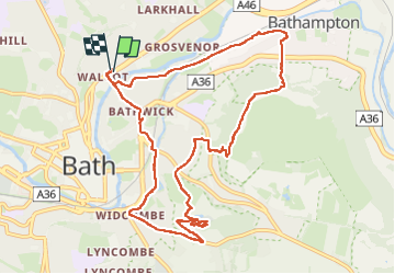
9,3 km | 12 km-effort 2h 43min Ja himpececilia j9 Bath Wandern Schwierig , England, Bath and North East Somerset, United Kingdom 12,5 km | 14,6 km-effort 3h 1min Nein