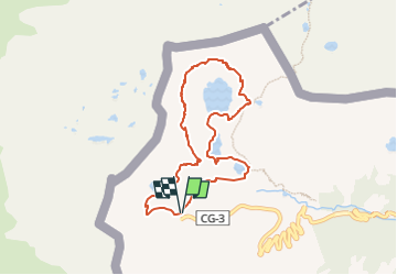
![](/images/other/stat-length.png)
![Tour Wandern Unknown - Andorre Estanys de Tristaina - Photo](https://media.geolcdn.com/t/1900/400/ext.pjpeg?maxdim=2&url=https%3A%2F%2Fstatic1.geolcdn.com%2Fsiteimages%2Fupload%2Ffiles%2F1553511878bg_sport_marche.png)
Andorre Estanys de Tristaina
Maryma
Benutzer
![Länge](/images/other/stat-length.png)
![Maximale Höhe](https://static1.geolcdn.com/siteimages/upload/files/1508320355ic_sort_altitude_max_24dp.png)
![Positive Höhendifferenz](https://static1.geolcdn.com/siteimages/upload/files/1508320355ic_sort_den_pos_24dp.png)
![Km-Effort](/images/other/stat-length.png)
![Min. Höhe](https://static1.geolcdn.com/siteimages/upload/files/1508320355ic_sort_altitude_min_24dp.png)
![Negative Höhendifferenz](https://static1.geolcdn.com/siteimages/upload/files/1508320355ic_sort_den_neg_24dp.png)
![Boucle](https://static1.geolcdn.com/siteimages/upload/files/16400158638029165_repeat_loop_refresh_sync_direction_icon.png)
![Wandern](https://static1.geolcdn.com/sitytour/trail-icons/101.png)
3h34
Schwierigkeit : Schwierig
![Scannen Sie diesen QR-Code, um die Tour in der SityTrail-Anwendung zu öffnen](https://capi.geolives.com/qq0zvz2zws4bq2lad0pu/sitytour/trails/4173952/qr.png?size=200)
Kostenlosegpshiking-Anwendung
Über SityTrail
Tour Wandern von 8 km verfügbar auf Andorra. Diese Tour wird von Maryma vorgeschlagen.
Beschreibung
Le parking le plus haut, celui d'Arcalis est fermé aux voitures et motos à partir de 8h30 et jusqu'à 17h30. Soit on passe avant cet horaire, soit on gare plus bas, au pied du télécabine et on rejoint Arcalis à pied, soit on prend le télécabine (20€).
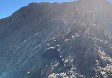
Le cirque de Tristaina est un entrelacement de chemins. Il y a les officiels GR et points jaunes et ceux qui sont visibles mais pas répertoriés. Il y a aussi la possibilité de faire des sommets, Costa de Radona, Tritaina, Creussans et la Punta de Peiraguils avec son mirador solaire, qui vaut le détour! Un télésiège y conduit!
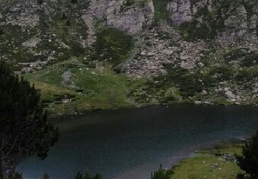
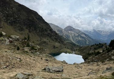
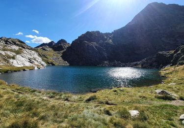
Des lacs magnifiques et sur la crête, on est sur la frontière avec la France.
Ort
Kommentare
Touren in der Umgebung
![Tour Wandern - llorts_lac_angonella - Photo](https://media.geolcdn.com/t/375/260/ext.jpg?maxdim=2&url=https%3A%2F%2Fservices.sitytrail.com%2FGeolivesWS%2FDownloadMedia.ashx%3FTrailID%3D793517%26Media%3Dfix__20170721150953.jpg)
![Wandern Wandern](https://static1.geolcdn.com/sitytour/trail-icons/101.png)
![Tour Wandern Auzat - Les étangs de la Gardelle - Auzat - Photo](https://media.geolcdn.com/t/375/260/ext.jpg?maxdim=2&url=https%3A%2F%2Fstatic1.geolcdn.com%2Fsiteimages%2Fupload%2Ffiles%2F1553511878bg_sport_marche.png)
![Wandern Wandern](https://static1.geolcdn.com/sitytour/trail-icons/101.png)
Wandern
![](/images/other/stat-length.png)
![](https://static1.geolcdn.com/siteimages/upload/files/16400158638029165_repeat_loop_refresh_sync_direction_icon.png)
![Wandern Wandern](https://static1.geolcdn.com/sitytour/trail-icons/101.png)
![Tour sport - Arcalis - Photo](https://media.geolcdn.com/t/375/260/04058f44-9f8f-463f-a1cc-559cb86b42ee.jpg&format=jpg&maxdim=2)
![Tour Wandern Auzat - Domaine de Montcalm -port Rat Pic Rouge - Photo](https://media.geolcdn.com/t/375/260/4ee9492f-31eb-4d1a-b77c-878ac1f5c4df.jpg&format=jpg&maxdim=2)
![Wandern Wandern](https://static1.geolcdn.com/sitytour/trail-icons/101.png)
Wandern
![](/images/other/stat-length.png)
![](https://static1.geolcdn.com/siteimages/upload/files/16400158638029165_repeat_loop_refresh_sync_direction_icon.png)
![Tour Wandern Auzat - Tour des lacs - Sarroucanes - Photo](https://media.geolcdn.com/t/375/260/45e48d9e-2f03-4378-bfe0-01a4ae1719c1.jpg&format=jpg&maxdim=2)
![Wandern Wandern](https://static1.geolcdn.com/sitytour/trail-icons/101.png)
Wandern
![](/images/other/stat-length.png)
![](https://static1.geolcdn.com/siteimages/upload/files/16400158638029165_repeat_loop_refresh_sync_direction_icon.png)
![Tour Wandern Auzat - Caraussans - Photo](https://media.geolcdn.com/t/375/260/13f3c7b9-396a-4438-ab57-e6debb7e127e.jpg&format=jpg&maxdim=2)
![Wandern Wandern](https://static1.geolcdn.com/sitytour/trail-icons/101.png)
Wandern
![](/images/other/stat-length.png)
![](https://static1.geolcdn.com/siteimages/upload/files/16400158638029165_repeat_loop_refresh_sync_direction_icon.png)
![Tour Wandern Auzat - Boucle etangs de la Gardelle - Photo](https://media.geolcdn.com/t/375/260/fb25dd7f-b9c3-45ab-85f7-b885de72aafa.jpg&format=jpg&maxdim=2)
![Wandern Wandern](https://static1.geolcdn.com/sitytour/trail-icons/101.png)
Wandern
![](/images/other/stat-length.png)
![](https://static1.geolcdn.com/siteimages/upload/files/16400158638029165_repeat_loop_refresh_sync_direction_icon.png)
![Tour Wandern Auzat - Fourcat - Photo](https://media.geolcdn.com/t/375/260/1246df19-c72a-49ce-9f67-6435cfda3815.jpg&format=jpg&maxdim=2)
![Wandern Wandern](https://static1.geolcdn.com/sitytour/trail-icons/101.png)
Wandern
![](/images/other/stat-length.png)
![](https://static1.geolcdn.com/siteimages/upload/files/16400158638029165_repeat_loop_refresh_sync_direction_icon.png)