![](/images/other/stat-length.png)
![Tour Wandern Pujo-le-Plan - autour de Pujo le Plan - Photo](https://media.geolcdn.com/t/1900/400/ext.pjpeg?maxdim=2&url=https%3A%2F%2Fstatic1.geolcdn.com%2Fsiteimages%2Fupload%2Ffiles%2F1553511878bg_sport_marche.png)
autour de Pujo le Plan
papiou
Benutzer
![Länge](/images/other/stat-length.png)
Länge
12,9 km
![Maximale Höhe](https://static1.geolcdn.com/siteimages/upload/files/1508320355ic_sort_altitude_max_24dp.png)
Maximale Höhe
107 m
![Positive Höhendifferenz](https://static1.geolcdn.com/siteimages/upload/files/1508320355ic_sort_den_pos_24dp.png)
Positive Höhendifferenz
138 m
![Km-Effort](/images/other/stat-length.png)
Km-Effort
14,7 km
![Min. Höhe](https://static1.geolcdn.com/siteimages/upload/files/1508320355ic_sort_altitude_min_24dp.png)
Min. Höhe
67 m
![Negative Höhendifferenz](https://static1.geolcdn.com/siteimages/upload/files/1508320355ic_sort_den_neg_24dp.png)
Negative Höhendifferenz
139 m
![Boucle](https://static1.geolcdn.com/siteimages/upload/files/16400158638029165_repeat_loop_refresh_sync_direction_icon.png)
Boucle
Ja
Erstellungsdatum :
2024-08-24 06:45:14.643
Letzte Änderung :
2024-08-24 11:48:49.661
![Wandern](https://static1.geolcdn.com/sitytour/trail-icons/101.png)
2h40
Schwierigkeit : Medium
![Scannen Sie diesen QR-Code, um die Tour in der SityTrail-Anwendung zu öffnen](https://capi.geolives.com/qq0zvz2zws4bq2lad0pu/sitytour/trails/4166549/qr.png?size=200)
Kostenlosegpshiking-Anwendung
Über SityTrail
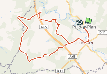
Tour Wandern von 12,9 km verfügbar auf Neu-Aquitanien, Landes, Pujo-le-Plan. Diese Tour wird von papiou vorgeschlagen.
Beschreibung
rdv mairie et dos à celle ci partir à gauche et suivre l'appli pour un circuit par route, près des champs et en forêt. Superbe circuit proposé par le Comité des fêtes de Pujo.
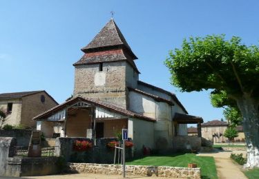
pour faire 10km, le départ peut se faire à l'église de Le Plan
Ort
Land:
France
Region :
Neu-Aquitanien
Abteilung/Provinz :
Landes
Kommune :
Pujo-le-Plan
Standort:
Unknown
Gehen Sie:(Dec)
Gehen Sie:(UTM)
714379 ; 4860027 (30T) N.
Kommentare
Touren in der Umgebung
![Tour Zu Fuß Villeneuve-de-Marsan - Petite Randonnée Villeneuve - Photo](https://media.geolcdn.com/t/375/260/9a1502fb-95da-4a41-b70c-7efd1ad3de51.jpeg&format=jpg&maxdim=2)
![Zu Fuß Zu Fuß](https://static1.geolcdn.com/sitytour/trail-icons/100.png)
Petite Randonnée Villeneuve
Zu Fuß
Einfach
Villeneuve-de-Marsan,
Neu-Aquitanien,
Landes,
France
![](/images/other/stat-length.png)
6,1 km | 7,1 km-effort
1h 36min
![](https://static1.geolcdn.com/siteimages/upload/files/16400158638029165_repeat_loop_refresh_sync_direction_icon.png)
Ja
![Tour Mountainbike Bougue - De Bougues à Gaillères - Photo](https://media.geolcdn.com/t/375/260/ext.jpg?maxdim=2&url=https%3A%2F%2Fservices.sitytrail.com%2FGeolivesWS%2FDownloadMedia.ashx%3FTrailID%3D102800%26Media%3D3962_1.jpg)
![Mountainbike Mountainbike](https://static1.geolcdn.com/sitytour/trail-icons/202.png)
De Bougues à Gaillères
Mountainbike
Medium
Bougue,
Neu-Aquitanien,
Landes,
France
![](/images/other/stat-length.png)
34 km | 39 km-effort
3h 0min
![](https://static1.geolcdn.com/siteimages/upload/files/16400158638029165_repeat_loop_refresh_sync_direction_icon.png)
Ja
![Tour Wandern Villeneuve-de-Marsan - Villeneuve, le midou. trace faite - Photo](https://media.geolcdn.com/t/375/260/ext.jpg?maxdim=2&url=https%3A%2F%2Fstatic1.geolcdn.com%2Fsiteimages%2Fupload%2Ffiles%2F1553511878bg_sport_marche.png)
![Wandern Wandern](https://static1.geolcdn.com/sitytour/trail-icons/101.png)
Villeneuve, le midou. trace faite
Wandern
Einfach
Villeneuve-de-Marsan,
Neu-Aquitanien,
Landes,
France
![](/images/other/stat-length.png)
7,6 km | 8,7 km-effort
1h 34min
![](https://static1.geolcdn.com/siteimages/upload/files/16400158638029165_repeat_loop_refresh_sync_direction_icon.png)
Ja
![Tour Wandern Saint-Gein - Saint Gein - Photo](https://media.geolcdn.com/t/375/260/ext.jpg?maxdim=2&url=https%3A%2F%2Fstatic1.geolcdn.com%2Fsiteimages%2Fupload%2Ffiles%2F1553511878bg_sport_marche.png)
![Wandern Wandern](https://static1.geolcdn.com/sitytour/trail-icons/101.png)
Saint Gein
Wandern
Schwierig
Saint-Gein,
Neu-Aquitanien,
Landes,
France
![](/images/other/stat-length.png)
10,4 km | 12,2 km-effort
2h 39min
![](https://static1.geolcdn.com/siteimages/upload/files/16400158638029165_repeat_loop_refresh_sync_direction_icon.png)
Ja
![Tour Wandern Maurrin - Maurin - Photo](https://media.geolcdn.com/t/375/260/ext.jpg?maxdim=2&url=https%3A%2F%2Fstatic1.geolcdn.com%2Fsiteimages%2Fupload%2Ffiles%2F1553511878bg_sport_marche.png)
![Wandern Wandern](https://static1.geolcdn.com/sitytour/trail-icons/101.png)
![Tour Wandern Bougue - Bougue laglorieuse 2022 - Photo](https://media.geolcdn.com/t/375/260/ext.jpg?maxdim=2&url=https%3A%2F%2Fstatic1.geolcdn.com%2Fsiteimages%2Fupload%2Ffiles%2F1553511878bg_sport_marche.png)
![Wandern Wandern](https://static1.geolcdn.com/sitytour/trail-icons/101.png)
Bougue laglorieuse 2022
Wandern
Sehr leicht
Bougue,
Neu-Aquitanien,
Landes,
France
![](/images/other/stat-length.png)
10,7 km | 12,5 km-effort
2h 22min
![](https://static1.geolcdn.com/siteimages/upload/files/16400158638029165_repeat_loop_refresh_sync_direction_icon.png)
Ja
![Tour Wandern Hontanx - Hontanx - Photo](https://media.geolcdn.com/t/375/260/ext.jpg?maxdim=2&url=https%3A%2F%2Fstatic1.geolcdn.com%2Fsiteimages%2Fupload%2Ffiles%2F1553511878bg_sport_marche.png)
![Wandern Wandern](https://static1.geolcdn.com/sitytour/trail-icons/101.png)
Hontanx
Wandern
Schwierig
Hontanx,
Neu-Aquitanien,
Landes,
France
![](/images/other/stat-length.png)
11,9 km | 13,7 km-effort
2h 33min
![](https://static1.geolcdn.com/siteimages/upload/files/16400158638029165_repeat_loop_refresh_sync_direction_icon.png)
Ja
![Tour Radtourismus Villeneuve-de-Marsan - Villeneuve de Marsan - Circuit de l'Armagnac - Photo](https://media.geolcdn.com/t/375/260/ext.jpg?maxdim=2&url=https%3A%2F%2Fstatic1.geolcdn.com%2Fsiteimages%2Fupload%2Ffiles%2F1524743154velo.jpg)
![Radtourismus Radtourismus](https://static1.geolcdn.com/sitytour/trail-icons/204.png)
Villeneuve de Marsan - Circuit de l'Armagnac
Radtourismus
Medium
Villeneuve-de-Marsan,
Neu-Aquitanien,
Landes,
France
![](/images/other/stat-length.png)
63 km | 72 km-effort
Unbekannt
![](https://static1.geolcdn.com/siteimages/upload/files/16400158638029165_repeat_loop_refresh_sync_direction_icon.png)
Ja
![Tour Wandern Bougue - boucle Bougue Laglorieuse - Photo](https://media.geolcdn.com/t/375/260/ext.jpg?maxdim=2&url=https%3A%2F%2Fstatic1.geolcdn.com%2Fsiteimages%2Fupload%2Ffiles%2F1553511878bg_sport_marche.png)
![Wandern Wandern](https://static1.geolcdn.com/sitytour/trail-icons/101.png)
boucle Bougue Laglorieuse
Wandern
Sehr leicht
Bougue,
Neu-Aquitanien,
Landes,
France
![](/images/other/stat-length.png)
10,5 km | 12,4 km-effort
2h 18min
![](https://static1.geolcdn.com/siteimages/upload/files/16400158638029165_repeat_loop_refresh_sync_direction_icon.png)
Ja