![](/images/other/stat-length.png)
![Tour Wandern Saint-Denis-des-Coudrais - De St Denis à Prevelles - Photo](https://media.geolcdn.com/t/1900/400/ext.pjpeg?maxdim=2&url=https%3A%2F%2Fstatic1.geolcdn.com%2Fsiteimages%2Fupload%2Ffiles%2F1553511878bg_sport_marche.png)
De St Denis à Prevelles
darkpapa
Benutzer
![Länge](/images/other/stat-length.png)
Länge
10,2 km
![Maximale Höhe](https://static1.geolcdn.com/siteimages/upload/files/1508320355ic_sort_altitude_max_24dp.png)
Maximale Höhe
164 m
![Positive Höhendifferenz](https://static1.geolcdn.com/siteimages/upload/files/1508320355ic_sort_den_pos_24dp.png)
Positive Höhendifferenz
193 m
![Km-Effort](/images/other/stat-length.png)
Km-Effort
12,8 km
![Min. Höhe](https://static1.geolcdn.com/siteimages/upload/files/1508320355ic_sort_altitude_min_24dp.png)
Min. Höhe
102 m
![Negative Höhendifferenz](https://static1.geolcdn.com/siteimages/upload/files/1508320355ic_sort_den_neg_24dp.png)
Negative Höhendifferenz
193 m
![Boucle](https://static1.geolcdn.com/siteimages/upload/files/16400158638029165_repeat_loop_refresh_sync_direction_icon.png)
Boucle
Ja
Erstellungsdatum :
2024-08-19 11:32:03.46
Letzte Änderung :
2024-08-25 09:37:56.138
![Wandern](https://static1.geolcdn.com/sitytour/trail-icons/101.png)
2h54
Schwierigkeit : Medium
![Mountainbike](https://static1.geolcdn.com/sitytour/trail-icons/202.png)
53m
Schwierigkeit : Einfach
![Scannen Sie diesen QR-Code, um die Tour in der SityTrail-Anwendung zu öffnen](https://capi.geolives.com/qq0zvz2zws4bq2lad0pu/sitytour/trails/4160698/qr.png?size=200)
Kostenlosegpshiking-Anwendung
Über SityTrail
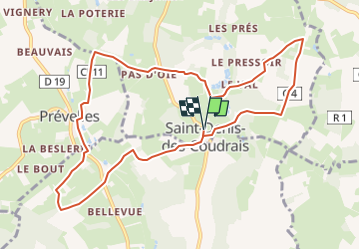
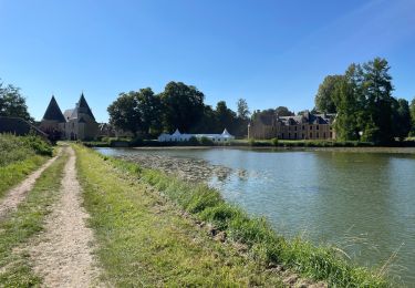
Tour Wandern von 10,2 km verfügbar auf Pays de la Loire, Sarthe, Saint-Denis-des-Coudrais. Diese Tour wird von darkpapa vorgeschlagen.
Beschreibung
Depart / retour place de la mairie
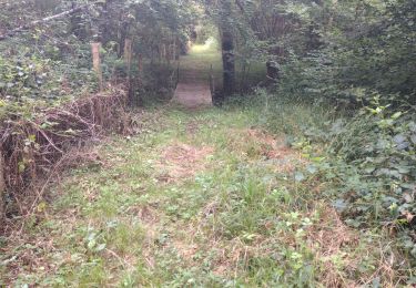
chemin creux et accidente
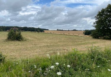
beau panorama sur les deux communes
Ort
Land:
France
Region :
Pays de la Loire
Abteilung/Provinz :
Sarthe
Kommune :
Saint-Denis-des-Coudrais
Standort:
Unknown
Gehen Sie:(Dec)
Gehen Sie:(UTM)
314563 ; 5336104 (31U) N.
Kommentare
Touren in der Umgebung
![Tour Wandern Saint-Georges-du-Rosay - Rosay et Jugeaux - Photo](https://media.geolcdn.com/t/375/260/af2a8428-78e5-4006-865e-2bb77d77453a.jpg&format=jpg&maxdim=2)
![Wandern Wandern](https://static1.geolcdn.com/sitytour/trail-icons/101.png)
Rosay et Jugeaux
Wandern
Medium
Saint-Georges-du-Rosay,
Pays de la Loire,
Sarthe,
France
![](/images/other/stat-length.png)
9,7 km | 11,2 km-effort
2h 32min
![](https://static1.geolcdn.com/siteimages/upload/files/16400158638029165_repeat_loop_refresh_sync_direction_icon.png)
Ja
![Tour Wandern Tuffé Val de la Chéronne - De Tuffé à Saint-Denis-des-Coudrais - Photo](https://media.geolcdn.com/t/375/260/ext.jpg?maxdim=2&url=https%3A%2F%2Fservices.sitytrail.com%2FGeolivesWS%2FDownloadMedia.ashx%3FTrailID%3D173060%26Media%3D14586_6.jpg)
![Wandern Wandern](https://static1.geolcdn.com/sitytour/trail-icons/101.png)
De Tuffé à Saint-Denis-des-Coudrais
Wandern
Schwierig
Tuffé Val de la Chéronne,
Pays de la Loire,
Sarthe,
France
![](/images/other/stat-length.png)
14,2 km | 17,1 km-effort
3h 34min
![](https://static1.geolcdn.com/siteimages/upload/files/16400158638029165_repeat_loop_refresh_sync_direction_icon.png)
Ja
![Tour Elektrofahrrad Tuffé Val de la Chéronne - Les hauts de Tuffé - Photo](https://media.geolcdn.com/t/375/260/043ef0bf-24e4-41e1-ab9b-acd49cd4faa2.jpg&format=jpg&maxdim=2)
![Elektrofahrrad Elektrofahrrad](https://static1.geolcdn.com/sitytour/trail-icons/205.png)
Les hauts de Tuffé
Elektrofahrrad
Einfach
Tuffé Val de la Chéronne,
Pays de la Loire,
Sarthe,
France
![](/images/other/stat-length.png)
33 km | 38 km-effort
1h 59min
![](https://static1.geolcdn.com/siteimages/upload/files/16400158638029165_repeat_loop_refresh_sync_direction_icon.png)
Ja
![Tour Elektrofahrrad Tuffé Val de la Chéronne - Tour du château le launey - Photo](https://media.geolcdn.com/t/375/260/469528cc-0e68-4d2d-bd7a-a5b22076745e.jpg&format=jpg&maxdim=2)
![Elektrofahrrad Elektrofahrrad](https://static1.geolcdn.com/sitytour/trail-icons/205.png)
Tour du château le launey
Elektrofahrrad
Sehr leicht
Tuffé Val de la Chéronne,
Pays de la Loire,
Sarthe,
France
![](/images/other/stat-length.png)
15,3 km | 17,1 km-effort
1h 7min
![](https://static1.geolcdn.com/siteimages/upload/files/16400158638029165_repeat_loop_refresh_sync_direction_icon.png)
Ja
![Tour Wandern Tuffé Val de la Chéronne - Truffe 14 ils - Photo](https://media.geolcdn.com/t/375/260/13ba31a6-fae8-46b3-bb84-f5d8f0a9b284.jpg&format=jpg&maxdim=2)
![Wandern Wandern](https://static1.geolcdn.com/sitytour/trail-icons/101.png)
Truffe 14 ils
Wandern
Tuffé Val de la Chéronne,
Pays de la Loire,
Sarthe,
France
![](/images/other/stat-length.png)
14 km | 17 km-effort
3h 30min
![](https://static1.geolcdn.com/siteimages/upload/files/16400158638029165_repeat_loop_refresh_sync_direction_icon.png)
Ja
![Tour Wandern Tuffé Val de la Chéronne - la vimelle - Photo](https://media.geolcdn.com/t/375/260/ext.jpg?maxdim=2&url=https%3A%2F%2Fstatic1.geolcdn.com%2Fsiteimages%2Fupload%2Ffiles%2F1553511878bg_sport_marche.png)
![Wandern Wandern](https://static1.geolcdn.com/sitytour/trail-icons/101.png)
la vimelle
Wandern
Einfach
Tuffé Val de la Chéronne,
Pays de la Loire,
Sarthe,
France
![](/images/other/stat-length.png)
10,2 km | 12,1 km-effort
2h 44min
![](https://static1.geolcdn.com/siteimages/upload/files/16400158638029165_repeat_loop_refresh_sync_direction_icon.png)
Ja
![Tour Wandern Boëssé-le-Sec - Autour de Boesse - Photo](https://media.geolcdn.com/t/375/260/ext.jpg?maxdim=2&url=https%3A%2F%2Fstatic1.geolcdn.com%2Fsiteimages%2Fupload%2Ffiles%2F1553511878bg_sport_marche.png)
![Wandern Wandern](https://static1.geolcdn.com/sitytour/trail-icons/101.png)
Autour de Boesse
Wandern
Einfach
Boëssé-le-Sec,
Pays de la Loire,
Sarthe,
France
![](/images/other/stat-length.png)
10,3 km | 12,7 km-effort
2h 53min
![](https://static1.geolcdn.com/siteimages/upload/files/16400158638029165_repeat_loop_refresh_sync_direction_icon.png)
Ja
![Tour Zu Fuß Tuffé Val de la Chéronne - Saint-Hilaire le lierru - Photo](https://media.geolcdn.com/t/375/260/ext.jpg?maxdim=2&url=https%3A%2F%2Fstatic1.geolcdn.com%2Fsiteimages%2Fupload%2Ffiles%2F1545311037marcheuse_200dpi.jpg)
![Zu Fuß Zu Fuß](https://static1.geolcdn.com/sitytour/trail-icons/100.png)
Saint-Hilaire le lierru
Zu Fuß
Einfach
Tuffé Val de la Chéronne,
Pays de la Loire,
Sarthe,
France
![](/images/other/stat-length.png)
10,3 km | 11,9 km-effort
2h 42min
![](https://static1.geolcdn.com/siteimages/upload/files/16400158638029165_repeat_loop_refresh_sync_direction_icon.png)
Ja
![Tour Zu Fuß Saint-Denis-des-Coudrais - saint Denis des Coudray - Photo](https://media.geolcdn.com/t/375/260/ext.jpg?maxdim=2&url=https%3A%2F%2Fstatic1.geolcdn.com%2Fsiteimages%2Fupload%2Ffiles%2F1545311037marcheuse_200dpi.jpg)
![Zu Fuß Zu Fuß](https://static1.geolcdn.com/sitytour/trail-icons/100.png)
saint Denis des Coudray
Zu Fuß
Einfach
Saint-Denis-des-Coudrais,
Pays de la Loire,
Sarthe,
France
![](/images/other/stat-length.png)
5,3 km | 6,4 km-effort
1h 27min
![](https://static1.geolcdn.com/siteimages/upload/files/16400158638029165_repeat_loop_refresh_sync_direction_icon.png)
Ja