![](/images/other/stat-length.png)
![Tour Wandern Moulineaux - Foret de la londe Moulineaux - Photo](https://media.geolcdn.com/t/1900/400/ext.pjpeg?maxdim=2&url=https%3A%2F%2Fstatic1.geolcdn.com%2Fsiteimages%2Fupload%2Ffiles%2F1553511878bg_sport_marche.png)
Foret de la londe Moulineaux
27MP
Benutzer
![Länge](/images/other/stat-length.png)
Länge
17,3 km
![Maximale Höhe](https://static1.geolcdn.com/siteimages/upload/files/1508320355ic_sort_altitude_max_24dp.png)
Maximale Höhe
142 m
![Positive Höhendifferenz](https://static1.geolcdn.com/siteimages/upload/files/1508320355ic_sort_den_pos_24dp.png)
Positive Höhendifferenz
370 m
![Km-Effort](/images/other/stat-length.png)
Km-Effort
22 km
![Min. Höhe](https://static1.geolcdn.com/siteimages/upload/files/1508320355ic_sort_altitude_min_24dp.png)
Min. Höhe
0 m
![Negative Höhendifferenz](https://static1.geolcdn.com/siteimages/upload/files/1508320355ic_sort_den_neg_24dp.png)
Negative Höhendifferenz
369 m
![Boucle](https://static1.geolcdn.com/siteimages/upload/files/16400158638029165_repeat_loop_refresh_sync_direction_icon.png)
Boucle
Ja
Erstellungsdatum :
2024-08-18 18:08:05.997
Letzte Änderung :
2024-08-18 18:10:23.16
![Wandern](https://static1.geolcdn.com/sitytour/trail-icons/101.png)
5h02
Schwierigkeit : Sehr schwierig
![Scannen Sie diesen QR-Code, um die Tour in der SityTrail-Anwendung zu öffnen](https://capi.geolives.com/qq0zvz2zws4bq2lad0pu/sitytour/trails/4160196/qr.png?size=200)
Kostenlosegpshiking-Anwendung
Über SityTrail
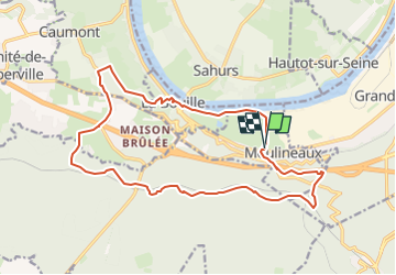
Tour Wandern von 17,3 km verfügbar auf Normandie, Seine-Maritime, Moulineaux. Diese Tour wird von 27MP vorgeschlagen.
Beschreibung
Depart du parking du moulin pres du stade, sentier le long de la Seine jusqu'a la Bouille, retour par la foret de la londe et le chateau de Robert le diable
Ort
Land:
France
Region :
Normandie
Abteilung/Provinz :
Seine-Maritime
Kommune :
Moulineaux
Standort:
Unknown
Gehen Sie:(Dec)
Gehen Sie:(UTM)
351755 ; 5467567 (31U) N.
Kommentare
Touren in der Umgebung
![Tour Wandern Hautot-sur-Seine - Hautot-sur-seine 11km - Photo](https://media.geolcdn.com/t/375/260/2e225eeb-e814-4a2c-a540-ca57c244afd9.jpg&format=jpg&maxdim=2)
![Wandern Wandern](https://static1.geolcdn.com/sitytour/trail-icons/101.png)
Hautot-sur-seine 11km
Wandern
Medium
(2)
Hautot-sur-Seine,
Normandie,
Seine-Maritime,
France
![](/images/other/stat-length.png)
11 km | 12,2 km-effort
2h 37min
![](https://static1.geolcdn.com/siteimages/upload/files/16400158638029165_repeat_loop_refresh_sync_direction_icon.png)
Ja
![Tour Wandern La Londe - La Londe 76- 13 km - Photo](https://media.geolcdn.com/t/375/260/23588b19-2689-475f-b2bd-10608cbf7253.jpg&format=jpg&maxdim=2)
![Wandern Wandern](https://static1.geolcdn.com/sitytour/trail-icons/101.png)
La Londe 76- 13 km
Wandern
Schwierig
(1)
La Londe,
Normandie,
Seine-Maritime,
France
![](/images/other/stat-length.png)
13 km | 16,1 km-effort
3h 43min
![](https://static1.geolcdn.com/siteimages/upload/files/16400158638029165_repeat_loop_refresh_sync_direction_icon.png)
Ja
![Tour Wandern Moulineaux - Robert-le-Diable - château - GD - V2 - Photo](https://media.geolcdn.com/t/375/260/ext.jpg?maxdim=2&url=https%3A%2F%2Fstatic1.geolcdn.com%2Fsiteimages%2Fupload%2Ffiles%2F1553511878bg_sport_marche.png)
![Wandern Wandern](https://static1.geolcdn.com/sitytour/trail-icons/101.png)
Robert-le-Diable - château - GD - V2
Wandern
Schwierig
(1)
Moulineaux,
Normandie,
Seine-Maritime,
France
![](/images/other/stat-length.png)
10,4 km | 13,1 km-effort
2h 58min
![](https://static1.geolcdn.com/siteimages/upload/files/16400158638029165_repeat_loop_refresh_sync_direction_icon.png)
Ja
![Wandern Wandern](https://static1.geolcdn.com/sitytour/trail-icons/101.png)
20240507-La Londe Cool
Wandern
Einfach
La Londe,
Normandie,
Seine-Maritime,
France
![](/images/other/stat-length.png)
7,3 km | 9,2 km-effort
2h 15min
![](https://static1.geolcdn.com/siteimages/upload/files/16400158638029165_repeat_loop_refresh_sync_direction_icon.png)
Ja
![Wandern Wandern](https://static1.geolcdn.com/sitytour/trail-icons/101.png)
la londe
Wandern
Schwierig
La Londe,
Normandie,
Seine-Maritime,
France
![](/images/other/stat-length.png)
11,6 km | 14,3 km-effort
3h 14min
![](https://static1.geolcdn.com/siteimages/upload/files/16400158638029165_repeat_loop_refresh_sync_direction_icon.png)
Nein
![Tour Wandern La Bouille - La Bouille- Cote Albert Lambert-Robert le Diable - Photo](https://media.geolcdn.com/t/375/260/6619d219-dc7a-4ef0-85ef-d79a78fa0fb8.jpg&format=jpg&maxdim=2)
![Wandern Wandern](https://static1.geolcdn.com/sitytour/trail-icons/101.png)
La Bouille- Cote Albert Lambert-Robert le Diable
Wandern
Schwierig
La Bouille,
Normandie,
Seine-Maritime,
France
![](/images/other/stat-length.png)
14,9 km | 18,8 km-effort
4h 23min
![](https://static1.geolcdn.com/siteimages/upload/files/16400158638029165_repeat_loop_refresh_sync_direction_icon.png)
Ja
![Tour Wandern Moulineaux - 20240227-Moulineaux Cool - Photo](https://media.geolcdn.com/t/375/260/3ac6da5d-fb2e-4aeb-8862-80cdf7511849.jpg&format=jpg&maxdim=2)
![Wandern Wandern](https://static1.geolcdn.com/sitytour/trail-icons/101.png)
20240227-Moulineaux Cool
Wandern
Einfach
Moulineaux,
Normandie,
Seine-Maritime,
France
![](/images/other/stat-length.png)
7,8 km | 8,7 km-effort
1h 49min
![](https://static1.geolcdn.com/siteimages/upload/files/16400158638029165_repeat_loop_refresh_sync_direction_icon.png)
Ja
![Tour Wandern Sahurs - 20231216-sahurs - Photo](https://media.geolcdn.com/t/375/260/6157c822-41a3-4d46-8844-2a9e1019e224.jpg&format=jpg&maxdim=2)
![Wandern Wandern](https://static1.geolcdn.com/sitytour/trail-icons/101.png)
20231216-sahurs
Wandern
Medium
Sahurs,
Normandie,
Seine-Maritime,
France
![](/images/other/stat-length.png)
12,8 km | 14,2 km-effort
3h 18min
![](https://static1.geolcdn.com/siteimages/upload/files/16400158638029165_repeat_loop_refresh_sync_direction_icon.png)
Ja
![Tour Wandern Moulineaux - Robert-Le-Diable - Moulineaux - PT - V2 - Photo](https://media.geolcdn.com/t/375/260/ext.jpg?maxdim=2&url=https%3A%2F%2Fstatic1.geolcdn.com%2Fsiteimages%2Fupload%2Ffiles%2F1553511878bg_sport_marche.png)
![Wandern Wandern](https://static1.geolcdn.com/sitytour/trail-icons/101.png)
Robert-Le-Diable - Moulineaux - PT - V2
Wandern
Medium
(1)
Moulineaux,
Normandie,
Seine-Maritime,
France
![](/images/other/stat-length.png)
5,2 km | 7,2 km-effort
1h 38min
![](https://static1.geolcdn.com/siteimages/upload/files/16400158638029165_repeat_loop_refresh_sync_direction_icon.png)
Ja