![](/images/other/stat-length.png)
![Tour Wandern West Cork - Allihies - Castletownbere - Photo](https://media.geolcdn.com/t/1900/400/5b2e47ce-d20b-4c9e-97bb-56e0a676777f.jpg&format=pjpeg&maxdim=2)
Allihies - Castletownbere
Geert H.
Benutzer
![Länge](/images/other/stat-length.png)
Länge
15,4 km
![Maximale Höhe](https://static1.geolcdn.com/siteimages/upload/files/1508320355ic_sort_altitude_max_24dp.png)
Maximale Höhe
297 m
![Positive Höhendifferenz](https://static1.geolcdn.com/siteimages/upload/files/1508320355ic_sort_den_pos_24dp.png)
Positive Höhendifferenz
510 m
![Km-Effort](/images/other/stat-length.png)
Km-Effort
22 km
![Min. Höhe](https://static1.geolcdn.com/siteimages/upload/files/1508320355ic_sort_altitude_min_24dp.png)
Min. Höhe
4 m
![Negative Höhendifferenz](https://static1.geolcdn.com/siteimages/upload/files/1508320355ic_sort_den_neg_24dp.png)
Negative Höhendifferenz
556 m
![Boucle](https://static1.geolcdn.com/siteimages/upload/files/16400158638029165_repeat_loop_refresh_sync_direction_icon.png)
Boucle
Nein
Erstellungsdatum :
2024-08-18 08:53:33.259
Letzte Änderung :
2024-08-23 10:20:38.932
![Wandern](https://static1.geolcdn.com/sitytour/trail-icons/101.png)
3h44
Schwierigkeit : Schwierig
![Scannen Sie diesen QR-Code, um die Tour in der SityTrail-Anwendung zu öffnen](https://capi.geolives.com/qq0zvz2zws4bq2lad0pu/sitytour/trails/4159831/qr.png?size=200)
Kostenlosegpshiking-Anwendung
Über SityTrail
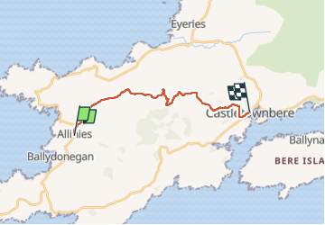
Tour Wandern von 15,4 km verfügbar auf Unbekannt, County Cork, West Cork. Diese Tour wird von Geert H. vorgeschlagen.
Beschreibung
The abandoned copper mines of Allihies, where copper mining was carried out for centuries, are the
central theme of today's hike. Although mining ceased in the mid-19th century, it continues to dominate the area to this day.
Ort
Land:
Ireland
Region :
Unbekannt
Abteilung/Provinz :
County Cork
Kommune :
West Cork
Standort:
Coulagh
Gehen Sie:(Dec)
Gehen Sie:(UTM)
427740 ; 5721587 (29U) N.
Kommentare
Touren in der Umgebung
![Tour Wandern West Cork - Ballydonegan Loop Allihies - Photo](https://media.geolcdn.com/t/375/260/ext.jpg?maxdim=2&url=https%3A%2F%2Fstatic1.geolcdn.com%2Fsiteimages%2Fupload%2Ffiles%2F1553511878bg_sport_marche.png)
![Wandern Wandern](https://static1.geolcdn.com/sitytour/trail-icons/101.png)
Ballydonegan Loop Allihies
Wandern
Schwierig
West Cork,
Unbekannt,
County Cork,
Ireland
![](/images/other/stat-length.png)
17,9 km | 24 km-effort
Unbekannt
![](https://static1.geolcdn.com/siteimages/upload/files/16400158638029165_repeat_loop_refresh_sync_direction_icon.png)
Ja