![](/images/other/stat-length.png)
![Tour Wandern Guérande - Guérande_Careil - Photo](https://media.geolcdn.com/t/1900/400/ext.pjpeg?maxdim=2&url=https%3A%2F%2Fservices.sitytrail.com%2FGeolivesWS%2FDownloadMedia.ashx%3FTrailID%3D415908%26Media%3D52a60e6b-5068-4f71-b8f3-923b38638fa7.jpg)
Guérande_Careil
neoroll44
Benutzer
![Länge](/images/other/stat-length.png)
Länge
13,5 km
![Maximale Höhe](https://static1.geolcdn.com/siteimages/upload/files/1508320355ic_sort_altitude_max_24dp.png)
Maximale Höhe
59 m
![Positive Höhendifferenz](https://static1.geolcdn.com/siteimages/upload/files/1508320355ic_sort_den_pos_24dp.png)
Positive Höhendifferenz
98 m
![Km-Effort](/images/other/stat-length.png)
Km-Effort
14,8 km
![Min. Höhe](https://static1.geolcdn.com/siteimages/upload/files/1508320355ic_sort_altitude_min_24dp.png)
Min. Höhe
-1 m
![Negative Höhendifferenz](https://static1.geolcdn.com/siteimages/upload/files/1508320355ic_sort_den_neg_24dp.png)
Negative Höhendifferenz
97 m
![Boucle](https://static1.geolcdn.com/siteimages/upload/files/16400158638029165_repeat_loop_refresh_sync_direction_icon.png)
Boucle
Ja
Erstellungsdatum :
2015-05-03 00:00:00.0
Letzte Änderung :
2015-05-03 00:00:00.0
![Wandern](https://static1.geolcdn.com/sitytour/trail-icons/101.png)
4h00
Schwierigkeit : Medium
![Scannen Sie diesen QR-Code, um die Tour in der SityTrail-Anwendung zu öffnen](https://capi.geolives.com/qq0zvz2zws4bq2lad0pu/sitytour/trails/415908/qr.png?size=200)
Kostenlosegpshiking-Anwendung
Über SityTrail
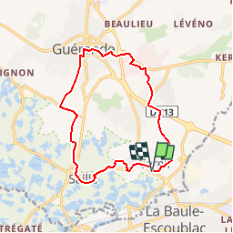
Tour Wandern von 13,5 km verfügbar auf Pays de la Loire, Loire-Atlantique, Guérande. Diese Tour wird von neoroll44 vorgeschlagen.
Beschreibung
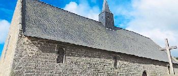
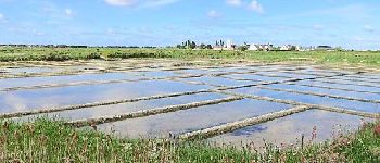
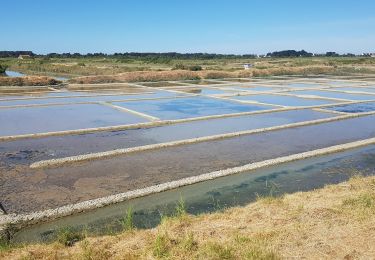
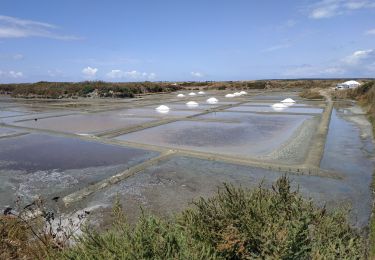
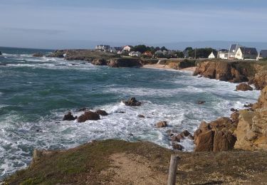
Depuis la chapelle de Careil, gagnez la vieille ville de Guérande par la piste cyclable et revenez par les marais salants de Saillé.
Ort
Land:
France
Region :
Pays de la Loire
Abteilung/Provinz :
Loire-Atlantique
Kommune :
Guérande
Standort:
Unknown
Gehen Sie:(Dec)
Gehen Sie:(UTM)
545088 ; 5238311 (30T) N.
Kommentare
Touren in der Umgebung
![Tour Wandern Guérande - De Guérande à La Turballe par les marais - Photo](https://media.geolcdn.com/t/375/260/ext.jpg?maxdim=2&url=https%3A%2F%2Fstatic1.geolcdn.com%2Fsiteimages%2Fupload%2Ffiles%2F1553511878bg_sport_marche.png)
![Wandern Wandern](https://static1.geolcdn.com/sitytour/trail-icons/101.png)
De Guérande à La Turballe par les marais
Wandern
Schwierig
(1)
Guérande,
Pays de la Loire,
Loire-Atlantique,
France
![](/images/other/stat-length.png)
22 km | 24 km-effort
6h 40min
![](https://static1.geolcdn.com/siteimages/upload/files/16400158638029165_repeat_loop_refresh_sync_direction_icon.png)
Ja
![Tour Zu Fuß La Baule-Escoublac - La petite marchande - Photo](https://media.geolcdn.com/t/375/260/b24b4250-06ce-4584-9aac-6ea2632f3c33.jpeg&format=jpg&maxdim=2)
![Zu Fuß Zu Fuß](https://static1.geolcdn.com/sitytour/trail-icons/100.png)
La petite marchande
Zu Fuß
Einfach
La Baule-Escoublac,
Pays de la Loire,
Loire-Atlantique,
France
![](/images/other/stat-length.png)
10,3 km | 11,4 km-effort
2h 35min
![](https://static1.geolcdn.com/siteimages/upload/files/16400158638029165_repeat_loop_refresh_sync_direction_icon.png)
Ja
![Tour Wandern Guérande - Guerande La Turballe et retour - Photo](https://media.geolcdn.com/t/375/260/18c14a3c-15ca-4d7c-a32e-6898f74dab5a.jpg&format=jpg&maxdim=2)
![Wandern Wandern](https://static1.geolcdn.com/sitytour/trail-icons/101.png)
Guerande La Turballe et retour
Wandern
Sehr leicht
Guérande,
Pays de la Loire,
Loire-Atlantique,
France
![](/images/other/stat-length.png)
22 km | 24 km-effort
4h 42min
![](https://static1.geolcdn.com/siteimages/upload/files/16400158638029165_repeat_loop_refresh_sync_direction_icon.png)
Ja
![Tour Wandern La Baule-Escoublac - gare de Pornichet - Photo](https://media.geolcdn.com/t/375/260/ext.jpg?maxdim=2&url=https%3A%2F%2Fservices.sitytrail.com%2FGeolivesWS%2FDownloadMedia.ashx%3FTrailID%3D993054%26Media%3D20180624205634.jpg)
![Wandern Wandern](https://static1.geolcdn.com/sitytour/trail-icons/101.png)
gare de Pornichet
Wandern
Sehr leicht
La Baule-Escoublac,
Pays de la Loire,
Loire-Atlantique,
France
![](/images/other/stat-length.png)
6,1 km | 6,9 km-effort
1h 25min
![](https://static1.geolcdn.com/siteimages/upload/files/16400158638029165_repeat_loop_refresh_sync_direction_icon.png)
Ja
![Tour Pfad Le Pouliguen - Plage de Nau-bout de Batz(18.5K 80D+) - Photo](https://media.geolcdn.com/t/375/260/6e876028-a079-49ae-b59a-7dbf260e65a6.jpg&format=jpg&maxdim=2)
![Pfad Pfad](https://static1.geolcdn.com/sitytour/trail-icons/104.png)
Plage de Nau-bout de Batz(18.5K 80D+)
Pfad
Medium
Le Pouliguen,
Pays de la Loire,
Loire-Atlantique,
France
![](/images/other/stat-length.png)
18,7 km | 20 km-effort
2h 19min
![](https://static1.geolcdn.com/siteimages/upload/files/16400158638029165_repeat_loop_refresh_sync_direction_icon.png)
Ja
![Tour Wandern Batz-sur-Mer - batz sur mer - Photo](https://media.geolcdn.com/t/375/260/3dd8e1cb-5e84-415d-9c6f-ae9534d5eb1e.jpg&format=jpg&maxdim=2)
![Wandern Wandern](https://static1.geolcdn.com/sitytour/trail-icons/101.png)
batz sur mer
Wandern
Medium
Batz-sur-Mer,
Pays de la Loire,
Loire-Atlantique,
France
![](/images/other/stat-length.png)
7,8 km | 8,5 km-effort
2h 47min
![](https://static1.geolcdn.com/siteimages/upload/files/16400158638029165_repeat_loop_refresh_sync_direction_icon.png)
Ja
![Tour Hybrid-Bike Guérande - 2023-07-25 Marais salants de Guérande - Photo](https://media.geolcdn.com/t/375/260/0a56980d-e337-4fe5-a1ee-9b7bab486125.jpg&format=jpg&maxdim=2)
![Hybrid-Bike Hybrid-Bike](https://static1.geolcdn.com/sitytour/trail-icons/203.png)
2023-07-25 Marais salants de Guérande
Hybrid-Bike
Schwierig
Guérande,
Pays de la Loire,
Loire-Atlantique,
France
![](/images/other/stat-length.png)
32 km | 33 km-effort
2h 9min
![](https://static1.geolcdn.com/siteimages/upload/files/16400158638029165_repeat_loop_refresh_sync_direction_icon.png)
Ja
![Tour Mountainbike Guérande - Le Croisic - Photo](https://media.geolcdn.com/t/375/260/3c586856-2120-4198-84d3-f552da8ad210.jpg&format=jpg&maxdim=2)
![Mountainbike Mountainbike](https://static1.geolcdn.com/sitytour/trail-icons/202.png)
Le Croisic
Mountainbike
Einfach
Guérande,
Pays de la Loire,
Loire-Atlantique,
France
![](/images/other/stat-length.png)
30 km | 32 km-effort
2h 59min
![](https://static1.geolcdn.com/siteimages/upload/files/16400158638029165_repeat_loop_refresh_sync_direction_icon.png)
Ja
![Tour Wandern La Baule-Escoublac - gare La Baule Escoubac - Photo](https://media.geolcdn.com/t/375/260/ext.jpg?maxdim=2&url=https%3A%2F%2Fservices.sitytrail.com%2FGeolivesWS%2FDownloadMedia.ashx%3FTrailID%3D994300%26Media%3D20180626202507.jpg)
![Wandern Wandern](https://static1.geolcdn.com/sitytour/trail-icons/101.png)
gare La Baule Escoubac
Wandern
Sehr leicht
La Baule-Escoublac,
Pays de la Loire,
Loire-Atlantique,
France
![](/images/other/stat-length.png)
5,1 km | 5,7 km-effort
1h 2min
![](https://static1.geolcdn.com/siteimages/upload/files/16400158638029165_repeat_loop_refresh_sync_direction_icon.png)
Ja