Tour Wandern West Cork - Hungry Hill - Photo
 Geert H.
Geert H.

Benutzer

© OpenStreetMap contributors
Länge
Länge
12,3 km
Maximale Höhe
Maximale Höhe
679 m
Positive Höhendifferenz
624 m
Km-Effort
Km-Effort  
21 km
Min. Höhe
Min. Höhe
31 m
Negative Höhendifferenz
693 m
Boucle
Boucle
Nein
Erstellungsdatum :
2024-08-17 08:52:57.032
Letzte Änderung :
2024-08-23 10:07:06.85

(0 Nachricht)

Wandern
Wandern
3h51
Schwierigkeit : Schwierig

Scannen Sie diesen QR-Code, um die Tour in der SityTrail-Anwendung zu öffnen

Kostenlosegpshiking-Anwendung

Logo SityTrail SityTrail

IGN / Geografische Institute

SityTrail aus dem App Store herunterladen SityTrail von Google Play herunterladen

Logo SityTrail SityTrail World

Die Welt öffnet sich für Sie

SityTrail aus dem App Store herunterladen SityTrail von Google Play herunterladen SityTrail auf Huawei AppGallery herunterladen

Über SityTrail

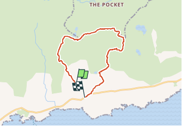
Tour Wandern von 12,3 km verfügbar auf Unbekannt, County Cork, West Cork. Diese Tour wird von Geert H. vorgeschlagen.

Beschreibung

Beware, this trail is impossible to follow when the visibility is poor. The markings uphill to the top are barely visible red paint markers or stone cairns. The path from the top downhill is not marked and was followed by following the "path" on the openstreet map and GPS. But it is adventurous to say at least.

Höhenprofil

Foto-Galerie

Ort

Land:
Ireland
Region :
Unbekannt
Abteilung/Provinz :
County Cork
Kommune :
West Cork
Standort:
Curryglass
Gehen Sie:(Dec)
Gehen Sie:(UTM)
442962 ; 5724521 (29U) N.

Touren in der Umgebung

Tour Wandern West Cork - All Rerrin Loop - Photo
Wandern
mlmoroneybb

Wandern

Einfach
West Cork, Unbekannt, County Cork, Ireland
6,4 km | 7,8 km-effort
Unbekannt
Ja


Schließen
Meine Abonnements