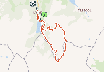
![](/images/other/stat-length.png)
![Tour Wandern Beaufort - St guerin - cormet d Arêches - miraillet- mirallet - Photo](https://media.geolcdn.com/t/1900/400/c9e2510c-27e3-4c87-a584-63d4276003bd.jpg&format=pjpeg&maxdim=2)
St guerin - cormet d Arêches - miraillet- mirallet
lolitrail
Benutzer
![Länge](/images/other/stat-length.png)
![Maximale Höhe](https://static1.geolcdn.com/siteimages/upload/files/1508320355ic_sort_altitude_max_24dp.png)
![Positive Höhendifferenz](https://static1.geolcdn.com/siteimages/upload/files/1508320355ic_sort_den_pos_24dp.png)
![Km-Effort](/images/other/stat-length.png)
![Min. Höhe](https://static1.geolcdn.com/siteimages/upload/files/1508320355ic_sort_altitude_min_24dp.png)
![Negative Höhendifferenz](https://static1.geolcdn.com/siteimages/upload/files/1508320355ic_sort_den_neg_24dp.png)
![Boucle](https://static1.geolcdn.com/siteimages/upload/files/16400158638029165_repeat_loop_refresh_sync_direction_icon.png)
![Wandern](https://static1.geolcdn.com/sitytour/trail-icons/101.png)
4h15
Schwierigkeit : Medium
![Scannen Sie diesen QR-Code, um die Tour in der SityTrail-Anwendung zu öffnen](https://capi.geolives.com/qq0zvz2zws4bq2lad0pu/sitytour/trails/4156507/qr.png?size=200)
Kostenlosegpshiking-Anwendung
Über SityTrail
Tour Wandern von 17 km verfügbar auf Auvergne-Rhone-Alpen, Savoyen, Beaufort. Diese Tour wird von lolitrail vorgeschlagen.
Beschreibung
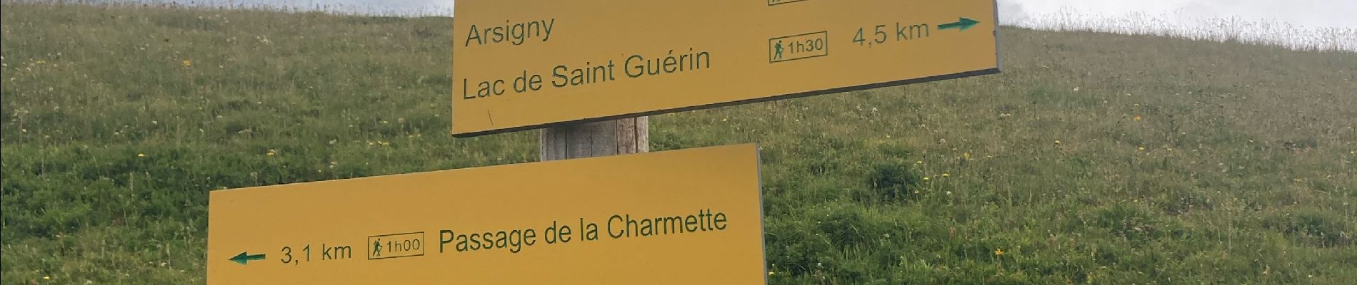
Très belle boucle . Ascension progressive par le lac des fées et le cormet d Arêches où de subîmes paysages s offrent à nous . Puis prendre la direction du col du couvercle puis descendre (attention passage très engagé ver le passage du miraillet avant d entamer la descente progressive vers le lac de st guerin
Ort
Kommentare
Touren in der Umgebung
![Tour Wandern Beaufort - D'Arêches au Col de Pré par le hameau de Boudin - Photo](https://media.geolcdn.com/t/375/260/ext.jpg?maxdim=2&url=https%3A%2F%2Fservices.sitytrail.com%2FGeolivesWS%2FDownloadMedia.ashx%3FTrailID%3D112688%26Media%3D11533_5.jpg)
![Wandern Wandern](https://static1.geolcdn.com/sitytour/trail-icons/101.png)
Wandern
![](/images/other/stat-length.png)
![](https://static1.geolcdn.com/siteimages/upload/files/16400158638029165_repeat_loop_refresh_sync_direction_icon.png)
![Tour Wandern Aime-la-Plagne - 2024-09-08 Marche Tour Beaufortain Refuge Coire vers Refuge Presset - Photo](https://media.geolcdn.com/t/375/260/b0c8e42e-e06a-4d0e-aaaf-41f5a8616494.jpg&format=jpg&maxdim=2)
![Wandern Wandern](https://static1.geolcdn.com/sitytour/trail-icons/101.png)
Wandern
![](/images/other/stat-length.png)
![](https://static1.geolcdn.com/siteimages/upload/files/16400158638029165_repeat_loop_refresh_sync_direction_icon.png)
![Tour Wandern Beaufort - suuntoapp-Hiking-2024-09-07T06-03-31Z - Photo](https://media.geolcdn.com/t/375/260/1c7a5e77-787c-4d14-8dd4-f96128769e9c.jpg&format=jpg&maxdim=2)
![Wandern Wandern](https://static1.geolcdn.com/sitytour/trail-icons/101.png)
Wandern
![](/images/other/stat-length.png)
![](https://static1.geolcdn.com/siteimages/upload/files/16400158638029165_repeat_loop_refresh_sync_direction_icon.png)
![Tour Skiwanderen Beaufort - Anticime de la pointe de la grande journée, montée couloir du grepets - Photo](https://media.geolcdn.com/t/375/260/8dfd1937-3bd4-42bd-a4fa-284d4bb8802e.jpg&format=jpg&maxdim=2)
![Skiwanderen Skiwanderen](https://static1.geolcdn.com/sitytour/trail-icons/503.png)
Skiwanderen
![](/images/other/stat-length.png)
![](https://static1.geolcdn.com/siteimages/upload/files/16400158638029165_repeat_loop_refresh_sync_direction_icon.png)
![Tour Skiwanderen Beaufort - Côte 2000 et col de Roche plane - Photo](https://media.geolcdn.com/t/375/260/38a11e49-5450-4382-89d2-44ae6ea43162.jpg&format=jpg&maxdim=2)
![Skiwanderen Skiwanderen](https://static1.geolcdn.com/sitytour/trail-icons/503.png)
Skiwanderen
![](/images/other/stat-length.png)
![](https://static1.geolcdn.com/siteimages/upload/files/16400158638029165_repeat_loop_refresh_sync_direction_icon.png)
![Tour Wandern Beaufort - lac de Presset et passeur de la Mintaz (belvédère de la Pierra Menta) - Photo](https://media.geolcdn.com/t/375/260/0e1a7432-483a-440c-958e-0a3e3d697f7b.jpg&format=jpg&maxdim=2)
![Wandern Wandern](https://static1.geolcdn.com/sitytour/trail-icons/101.png)
Wandern
![](/images/other/stat-length.png)
![](https://static1.geolcdn.com/siteimages/upload/files/16400158638029165_repeat_loop_refresh_sync_direction_icon.png)
![Tour Wandern Beaufort - Lac d’Amour - col du Coin 10 km -680 m dénivelé + - Photo](https://media.geolcdn.com/t/375/260/3b47f1f6-ac20-42ea-91ad-660067538617.jpg&format=jpg&maxdim=2)
![Wandern Wandern](https://static1.geolcdn.com/sitytour/trail-icons/101.png)
Wandern
![](/images/other/stat-length.png)
![](https://static1.geolcdn.com/siteimages/upload/files/16400158638029165_repeat_loop_refresh_sync_direction_icon.png)
![Tour Wandern Beaufort - Barrage St Guerin Refuge de l’Econdu 12 km - 600 m d’en + - Photo](https://media.geolcdn.com/t/375/260/e237980d-0989-4662-bd24-20be909d7e5b.jpg&format=jpg&maxdim=2)
![Wandern Wandern](https://static1.geolcdn.com/sitytour/trail-icons/101.png)
Wandern
![](/images/other/stat-length.png)
![](https://static1.geolcdn.com/siteimages/upload/files/16400158638029165_repeat_loop_refresh_sync_direction_icon.png)
![Tour Wandern Beaufort - Le pas de l’âne 10 km 850 m dénivelé + - Photo](https://media.geolcdn.com/t/375/260/e16223c0-d24b-4318-beff-cfc74b9fa02c.jpg&format=jpg&maxdim=2)
![Wandern Wandern](https://static1.geolcdn.com/sitytour/trail-icons/101.png)
Wandern
![](/images/other/stat-length.png)
![](https://static1.geolcdn.com/siteimages/upload/files/16400158638029165_repeat_loop_refresh_sync_direction_icon.png)