![](/images/other/stat-length.png)
![Tour Wandern Mauriac - le trou du loup - Photo](https://media.geolcdn.com/t/1900/400/5c4a4021-23ce-407c-8860-acc4710ecdad.jpg&format=pjpeg&maxdim=2)
le trou du loup
Jean Yves Erard
Benutzer
![Länge](/images/other/stat-length.png)
Länge
14,1 km
![Maximale Höhe](https://static1.geolcdn.com/siteimages/upload/files/1508320355ic_sort_altitude_max_24dp.png)
Maximale Höhe
714 m
![Positive Höhendifferenz](https://static1.geolcdn.com/siteimages/upload/files/1508320355ic_sort_den_pos_24dp.png)
Positive Höhendifferenz
488 m
![Km-Effort](/images/other/stat-length.png)
Km-Effort
21 km
![Min. Höhe](https://static1.geolcdn.com/siteimages/upload/files/1508320355ic_sort_altitude_min_24dp.png)
Min. Höhe
416 m
![Negative Höhendifferenz](https://static1.geolcdn.com/siteimages/upload/files/1508320355ic_sort_den_neg_24dp.png)
Negative Höhendifferenz
488 m
![Boucle](https://static1.geolcdn.com/siteimages/upload/files/16400158638029165_repeat_loop_refresh_sync_direction_icon.png)
Boucle
Ja
Erstellungsdatum :
2024-08-15 09:14:09.776
Letzte Änderung :
2024-08-15 13:18:38.788
![Wandern](https://static1.geolcdn.com/sitytour/trail-icons/101.png)
4h03
Schwierigkeit : Sehr schwierig
![Scannen Sie diesen QR-Code, um die Tour in der SityTrail-Anwendung zu öffnen](https://capi.geolives.com/qq0zvz2zws4bq2lad0pu/sitytour/trails/4156325/qr.png?size=200)
Kostenlosegpshiking-Anwendung
Über SityTrail
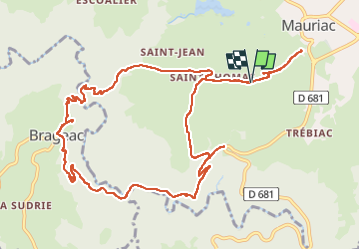
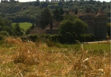
Tour Wandern von 14,1 km verfügbar auf Auvergne-Rhone-Alpen, Cantal, Mauriac. Diese Tour wird von Jean Yves Erard vorgeschlagen.
Beschreibung
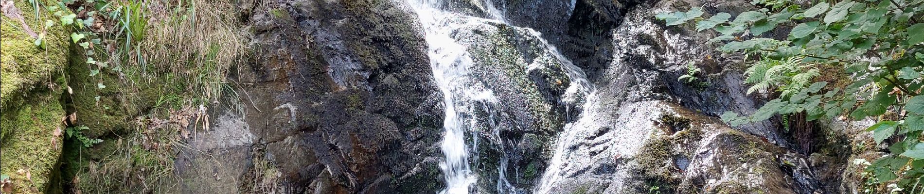
rando assez physique. excellent entraînement.
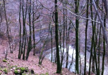
on s' est trompé au départ en essayant de suivre un ancien PR vert ( effacé) d'où notre point de départ
Ort
Land:
France
Region :
Auvergne-Rhone-Alpen
Abteilung/Provinz :
Cantal
Kommune :
Mauriac
Standort:
Unknown
Gehen Sie:(Dec)
Gehen Sie:(UTM)
446769 ; 5006591 (31T) N.
Kommentare
Touren in der Umgebung
![Tour Fahrrad Brageac - velo20180820 - Photo](https://media.geolcdn.com/t/375/260/ext.jpg?maxdim=2&url=https%3A%2F%2Fservices.sitytrail.com%2FGeolivesWS%2FDownloadMedia.ashx%3FTrailID%3D1025427%26Media%3D20180820133943.jpg)
![Fahrrad Fahrrad](https://static1.geolcdn.com/sitytour/trail-icons/200.png)
velo20180820
Fahrrad
Sehr leicht
Brageac,
Auvergne-Rhone-Alpen,
Cantal,
France
![](/images/other/stat-length.png)
40 km | 53 km-effort
2h 49min
![](https://static1.geolcdn.com/siteimages/upload/files/16400158638029165_repeat_loop_refresh_sync_direction_icon.png)
Ja
![Tour Andere Aktivitäten Escorailles - 16.8.2013 - Photo](https://media.geolcdn.com/t/375/260/ext.jpg?maxdim=2&url=https%3A%2F%2Fservices.sitytrail.com%2FGeolivesWS%2FDownloadMedia.ashx%3FTrailID%3D213660%26Media%3D20130816122543.jpg)
![Andere Aktivitäten Andere Aktivitäten](https://static1.geolcdn.com/sitytour/trail-icons/900.png)
16.8.2013
Andere Aktivitäten
Medium
Escorailles,
Auvergne-Rhone-Alpen,
Cantal,
France
![](/images/other/stat-length.png)
7,3 km | 10,4 km-effort
2h 49min
![](https://static1.geolcdn.com/siteimages/upload/files/16400158638029165_repeat_loop_refresh_sync_direction_icon.png)
Ja
![Tour Wandern Escorailles - la trizague - Photo](https://media.geolcdn.com/t/375/260/ext.jpg?maxdim=2&url=https%3A%2F%2Fservices.sitytrail.com%2FGeolivesWS%2FDownloadMedia.ashx%3FTrailID%3D178705%26Media%3D20130308164246.jpg)
![Wandern Wandern](https://static1.geolcdn.com/sitytour/trail-icons/101.png)
la trizague
Wandern
Sehr leicht
Escorailles,
Auvergne-Rhone-Alpen,
Cantal,
France
![](/images/other/stat-length.png)
4,2 km | 6,5 km-effort
1h 31min
![](https://static1.geolcdn.com/siteimages/upload/files/16400158638029165_repeat_loop_refresh_sync_direction_icon.png)
Nein
![Tour Rennrad Mauriac - Neuvic d'Ussel - Photo](https://media.geolcdn.com/t/375/260/ext.jpg?maxdim=2&url=https%3A%2F%2Fstatic1.geolcdn.com%2Fsiteimages%2Fupload%2Ffiles%2F1524743154velo.jpg)
![Rennrad Rennrad](https://static1.geolcdn.com/sitytour/trail-icons/201.png)
Neuvic d'Ussel
Rennrad
Medium
Mauriac,
Auvergne-Rhone-Alpen,
Cantal,
France
![](/images/other/stat-length.png)
62 km | 77 km-effort
3h 12min
![](https://static1.geolcdn.com/siteimages/upload/files/16400158638029165_repeat_loop_refresh_sync_direction_icon.png)
Ja
![Tour Wandern Le Vigean - 20210616 Chambres - Photo](https://media.geolcdn.com/t/375/260/6d67eb90-dd6e-4d37-b951-f6e62fcd2e1e.jpg&format=jpg&maxdim=2)
![Wandern Wandern](https://static1.geolcdn.com/sitytour/trail-icons/101.png)
20210616 Chambres
Wandern
Medium
(1)
Le Vigean,
Auvergne-Rhone-Alpen,
Cantal,
France
![](/images/other/stat-length.png)
6,4 km | 8,3 km-effort
3h 12min
![](https://static1.geolcdn.com/siteimages/upload/files/16400158638029165_repeat_loop_refresh_sync_direction_icon.png)
Ja
![Tour Wandern Le Vigean - Le Vigean - Photo](https://media.geolcdn.com/t/375/260/ext.jpg?maxdim=2&url=https%3A%2F%2Fstatic1.geolcdn.com%2Fsiteimages%2Fupload%2Ffiles%2F1553511878bg_sport_marche.png)
![Wandern Wandern](https://static1.geolcdn.com/sitytour/trail-icons/101.png)
Le Vigean
Wandern
Schwierig
Le Vigean,
Auvergne-Rhone-Alpen,
Cantal,
France
![](/images/other/stat-length.png)
15 km | 17,2 km-effort
1h 30min
![](https://static1.geolcdn.com/siteimages/upload/files/16400158638029165_repeat_loop_refresh_sync_direction_icon.png)
Nein
![Tour Wandern Escorailles - 06.08.2013 - Photo](https://media.geolcdn.com/t/375/260/ext.jpg?maxdim=2&url=https%3A%2F%2Fstatic1.geolcdn.com%2Fsiteimages%2Fupload%2Ffiles%2F1553511878bg_sport_marche.png)
![Wandern Wandern](https://static1.geolcdn.com/sitytour/trail-icons/101.png)
06.08.2013
Wandern
Sehr leicht
Escorailles,
Auvergne-Rhone-Alpen,
Cantal,
France
![](/images/other/stat-length.png)
4,3 km | 6,5 km-effort
1h 58min
![](https://static1.geolcdn.com/siteimages/upload/files/16400158638029165_repeat_loop_refresh_sync_direction_icon.png)
Nein
![Tour Wandern Le Vigean - 2024-06-24_09h02m06_Le_sentier_du_Catou - Photo](https://media.geolcdn.com/t/375/260/ext.jpg?maxdim=2&url=https%3A%2F%2Fstatic1.geolcdn.com%2Fsiteimages%2Fupload%2Ffiles%2F1553511878bg_sport_marche.png)
![Wandern Wandern](https://static1.geolcdn.com/sitytour/trail-icons/101.png)
2024-06-24_09h02m06_Le_sentier_du_Catou
Wandern
Medium
Le Vigean,
Auvergne-Rhone-Alpen,
Cantal,
France
![](/images/other/stat-length.png)
6,2 km | 8,1 km-effort
1h 50min
![](https://static1.geolcdn.com/siteimages/upload/files/16400158638029165_repeat_loop_refresh_sync_direction_icon.png)
Ja
![Tour Wandern Mauriac - Rando fête de la pompe - Photo](https://media.geolcdn.com/t/375/260/ext.jpg?maxdim=2&url=https%3A%2F%2Fstatic1.geolcdn.com%2Fsiteimages%2Fupload%2Ffiles%2F1553511878bg_sport_marche.png)
![Wandern Wandern](https://static1.geolcdn.com/sitytour/trail-icons/101.png)
Rando fête de la pompe
Wandern
Medium
Mauriac,
Auvergne-Rhone-Alpen,
Cantal,
France
![](/images/other/stat-length.png)
8 km | 10,4 km-effort
1h 48min
![](https://static1.geolcdn.com/siteimages/upload/files/16400158638029165_repeat_loop_refresh_sync_direction_icon.png)
Ja