![](/images/other/stat-length.png)
![Tour Wandern Cambronne-lès-Clermont - Cambronne-Lès-Clermont_La vallée de Vaux_8,3 km - Photo](https://media.geolcdn.com/t/1900/400/ext.pjpeg?maxdim=2&url=https%3A%2F%2Fstatic1.geolcdn.com%2Fsiteimages%2Fupload%2Ffiles%2F1553511878bg_sport_marche.png)
Cambronne-Lès-Clermont_La vallée de Vaux_8,3 km
Pousscailleux
Benutzer
![Länge](/images/other/stat-length.png)
Länge
8,3 km
![Maximale Höhe](https://static1.geolcdn.com/siteimages/upload/files/1508320355ic_sort_altitude_max_24dp.png)
Maximale Höhe
127 m
![Positive Höhendifferenz](https://static1.geolcdn.com/siteimages/upload/files/1508320355ic_sort_den_pos_24dp.png)
Positive Höhendifferenz
145 m
![Km-Effort](/images/other/stat-length.png)
Km-Effort
10,3 km
![Min. Höhe](https://static1.geolcdn.com/siteimages/upload/files/1508320355ic_sort_altitude_min_24dp.png)
Min. Höhe
50 m
![Negative Höhendifferenz](https://static1.geolcdn.com/siteimages/upload/files/1508320355ic_sort_den_neg_24dp.png)
Negative Höhendifferenz
145 m
![Boucle](https://static1.geolcdn.com/siteimages/upload/files/16400158638029165_repeat_loop_refresh_sync_direction_icon.png)
Boucle
Ja
Erstellungsdatum :
2015-05-01 00:00:00.0
Letzte Änderung :
2015-05-01 00:00:00.0
![Wandern](https://static1.geolcdn.com/sitytour/trail-icons/101.png)
2h14
Schwierigkeit : Medium
![Scannen Sie diesen QR-Code, um die Tour in der SityTrail-Anwendung zu öffnen](https://capi.geolives.com/qq0zvz2zws4bq2lad0pu/sitytour/trails/414818/qr.png?size=200)
Kostenlosegpshiking-Anwendung
Über SityTrail
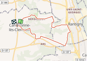
Tour Wandern von 8,3 km verfügbar auf Nordfrankreich, Oise, Cambronne-lès-Clermont. Diese Tour wird von Pousscailleux vorgeschlagen.
Beschreibung
Départ parking (111)rue de Clermont, Cambronne-lès-Clermont.
Coordonnées : N49°19'46"/E002°23'55.30"
Ort
Land:
France
Region :
Nordfrankreich
Abteilung/Provinz :
Oise
Kommune :
Cambronne-lès-Clermont
Standort:
Unknown
Gehen Sie:(Dec)
Gehen Sie:(UTM)
456307 ; 5464288 (31U) N.
Kommentare
Touren in der Umgebung
![Tour Wandern Bury - Bury_Trace GPS_8,9 km - Photo](https://media.geolcdn.com/t/375/260/ext.jpg?maxdim=2&url=https%3A%2F%2Fstatic1.geolcdn.com%2Fsiteimages%2Fupload%2Ffiles%2F1553511878bg_sport_marche.png)
![Wandern Wandern](https://static1.geolcdn.com/sitytour/trail-icons/101.png)
Bury_Trace GPS_8,9 km
Wandern
Medium
(1)
Bury,
Nordfrankreich,
Oise,
France
![](/images/other/stat-length.png)
8,9 km | 11,1 km-effort
2h 25min
![](https://static1.geolcdn.com/siteimages/upload/files/16400158638029165_repeat_loop_refresh_sync_direction_icon.png)
Ja
![Tour Wandern Bailleval - Rando cavée des Vaches - Photo](https://media.geolcdn.com/t/375/260/f37983ff-a1d8-4a86-849e-b7078bba4408.jpg&format=jpg&maxdim=2)
![Wandern Wandern](https://static1.geolcdn.com/sitytour/trail-icons/101.png)
Rando cavée des Vaches
Wandern
Einfach
Bailleval,
Nordfrankreich,
Oise,
France
![](/images/other/stat-length.png)
9,5 km | 11,6 km-effort
2h 49min
![](https://static1.geolcdn.com/siteimages/upload/files/16400158638029165_repeat_loop_refresh_sync_direction_icon.png)
Ja
![Tour Wandern Breuil-le-Sec - 2024 07 27 - Photo](https://media.geolcdn.com/t/375/260/ext.jpg?maxdim=2&url=https%3A%2F%2Fstatic1.geolcdn.com%2Fsiteimages%2Fupload%2Ffiles%2F1553511878bg_sport_marche.png)
![Wandern Wandern](https://static1.geolcdn.com/sitytour/trail-icons/101.png)
2024 07 27
Wandern
Einfach
Breuil-le-Sec,
Nordfrankreich,
Oise,
France
![](/images/other/stat-length.png)
16,3 km | 21 km-effort
4h 0min
![](https://static1.geolcdn.com/siteimages/upload/files/16400158638029165_repeat_loop_refresh_sync_direction_icon.png)
Ja
![Tour Wandern Rantigny - Vaux Cambrone - Photo](https://media.geolcdn.com/t/375/260/7c14bdf1-d89c-4420-8bc5-b019b2f1a6db.jpg&format=jpg&maxdim=2)
![Wandern Wandern](https://static1.geolcdn.com/sitytour/trail-icons/101.png)
![Tour Wandern Laigneville - Laigneville-Barisseuse 8k2 - Photo](https://media.geolcdn.com/t/375/260/ext.jpg?maxdim=2&url=https%3A%2F%2Fstatic1.geolcdn.com%2Fsiteimages%2Fupload%2Ffiles%2F1553511878bg_sport_marche.png)
![Wandern Wandern](https://static1.geolcdn.com/sitytour/trail-icons/101.png)
Laigneville-Barisseuse 8k2
Wandern
Medium
Laigneville,
Nordfrankreich,
Oise,
France
![](/images/other/stat-length.png)
8,2 km | 9,7 km-effort
2h 11min
![](https://static1.geolcdn.com/siteimages/upload/files/16400158638029165_repeat_loop_refresh_sync_direction_icon.png)
Ja
![Tour Elektrofahrrad Breuil-le-Sec - 2023 12 03 - Photo](https://media.geolcdn.com/t/375/260/ext.jpg?maxdim=2&url=https%3A%2F%2Fstatic1.geolcdn.com%2Fsiteimages%2Fupload%2Ffiles%2F1524743154velo.jpg)
![Elektrofahrrad Elektrofahrrad](https://static1.geolcdn.com/sitytour/trail-icons/205.png)
2023 12 03
Elektrofahrrad
Medium
Breuil-le-Sec,
Nordfrankreich,
Oise,
France
![](/images/other/stat-length.png)
38 km | 51 km-effort
3h 27min
![](https://static1.geolcdn.com/siteimages/upload/files/16400158638029165_repeat_loop_refresh_sync_direction_icon.png)
Ja
![Tour Elektrofahrrad Breuil-le-Sec - 2022 10 29 - Photo](https://media.geolcdn.com/t/375/260/ext.jpg?maxdim=2&url=https%3A%2F%2Fstatic1.geolcdn.com%2Fsiteimages%2Fupload%2Ffiles%2F1524743154velo.jpg)
![Elektrofahrrad Elektrofahrrad](https://static1.geolcdn.com/sitytour/trail-icons/205.png)
2022 10 29
Elektrofahrrad
Medium
Breuil-le-Sec,
Nordfrankreich,
Oise,
France
![](/images/other/stat-length.png)
47 km | 57 km-effort
4h 47min
![](https://static1.geolcdn.com/siteimages/upload/files/16400158638029165_repeat_loop_refresh_sync_direction_icon.png)
Ja
![Tour Elektrofahrrad Breuil-le-Sec - 2022 10 08 - Photo](https://media.geolcdn.com/t/375/260/ext.jpg?maxdim=2&url=https%3A%2F%2Fstatic1.geolcdn.com%2Fsiteimages%2Fupload%2Ffiles%2F1524743154velo.jpg)
![Elektrofahrrad Elektrofahrrad](https://static1.geolcdn.com/sitytour/trail-icons/205.png)
2022 10 08
Elektrofahrrad
Einfach
Breuil-le-Sec,
Nordfrankreich,
Oise,
France
![](/images/other/stat-length.png)
29 km | 36 km-effort
3h 21min
![](https://static1.geolcdn.com/siteimages/upload/files/16400158638029165_repeat_loop_refresh_sync_direction_icon.png)
Ja
![Tour sport Monchy-Saint-Éloi - 2022-09-28_13h36m37_<CAC9XJQ5buBJim13UVmX+3WM3tvG2H9PncH-espriqxQdtYHG3Q@mailgmailcom>_chedeville-9kmsgpxchedeville-9kms - Photo](https://media.geolcdn.com/t/375/260/ext.jpg?maxdim=2&url=https%3A%2F%2Fsecurestorage.geolives.com%2Fsitytour%2Ftrail-bg%2Fdefault.jpg)
2022-09-28_13h36m37_
sport
Sehr leicht
Monchy-Saint-Éloi,
Nordfrankreich,
Oise,
France
![](/images/other/stat-length.png)
8 km | 9,5 km-effort
Unbekannt
![](https://static1.geolcdn.com/siteimages/upload/files/16400158638029165_repeat_loop_refresh_sync_direction_icon.png)
Ja