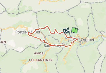
![](/images/other/stat-length.png)
![Tour Mountainbike Galey - Galey VTT électrique - Photo](https://media.geolcdn.com/t/1900/400/ext.pjpeg?maxdim=2&url=https%3A%2F%2Fstatic1.geolcdn.com%2Fsiteimages%2Fupload%2Ffiles%2F1524743154velo.jpg)
Galey VTT électrique
Yonl
Benutzer
![Länge](/images/other/stat-length.png)
![Maximale Höhe](https://static1.geolcdn.com/siteimages/upload/files/1508320355ic_sort_altitude_max_24dp.png)
![Positive Höhendifferenz](https://static1.geolcdn.com/siteimages/upload/files/1508320355ic_sort_den_pos_24dp.png)
![Km-Effort](/images/other/stat-length.png)
![Min. Höhe](https://static1.geolcdn.com/siteimages/upload/files/1508320355ic_sort_altitude_min_24dp.png)
![Negative Höhendifferenz](https://static1.geolcdn.com/siteimages/upload/files/1508320355ic_sort_den_neg_24dp.png)
![Boucle](https://static1.geolcdn.com/siteimages/upload/files/16400158638029165_repeat_loop_refresh_sync_direction_icon.png)
![Mountainbike](https://static1.geolcdn.com/sitytour/trail-icons/202.png)
2h10
Schwierigkeit : Schwierig
![Elektrofahrrad](https://static1.geolcdn.com/sitytour/trail-icons/205.png)
1h40
Schwierigkeit : Medium
![Scannen Sie diesen QR-Code, um die Tour in der SityTrail-Anwendung zu öffnen](https://capi.geolives.com/qq0zvz2zws4bq2lad0pu/sitytour/trails/4145965/qr.png?size=200)
Kostenlosegpshiking-Anwendung
Über SityTrail
Tour Mountainbike von 13,7 km verfügbar auf Okzitanien, Ariège, Galey. Diese Tour wird von Yonl vorgeschlagen.
Beschreibung
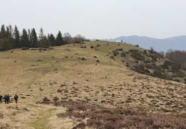
Boucle sympathique faisable par presque tout le monde en VTT électrique.
Faisable en VTT musculaire également pour les plus robustes et entrainés car certaines montées sont très raides.
Certains passages sont un peu étroits et tendus mais cela reste globalement faisable par presque tout le monde (au pire, vous descendez du vélo sur les passages complexes).
Ort
Kommentare
Touren in der Umgebung
![Tour Wandern Portet-d'Aspet - 2023 09 21 CHEMIN du PIÉMONT PYRÉNÉEN - 14ème étape : Portet-d’Aspet - le Col - Juzet-d’Izaut - St Pet-d’Ardet - Barbazan - Valcabrère - st Bertrand de Comminges - Photo](https://media.geolcdn.com/t/375/260/aef99e2b-7039-4bd2-8756-4eb0da2534bf.jpg&format=jpg&maxdim=2)
![Wandern Wandern](https://static1.geolcdn.com/sitytour/trail-icons/101.png)
Wandern
![](/images/other/stat-length.png)
![](https://static1.geolcdn.com/siteimages/upload/files/16400158638029165_repeat_loop_refresh_sync_direction_icon.png)
![Tour Wandern Herran - 2020-08-20 Arbas - cabane de roqué pic - de paloumère - sommet de cornudère. - Photo](https://media.geolcdn.com/t/375/260/39ca0dbe-795b-4eed-9859-2fae2868de95.jpg&format=jpg&maxdim=2)
![Wandern Wandern](https://static1.geolcdn.com/sitytour/trail-icons/101.png)
Wandern
![](/images/other/stat-length.png)
![](https://static1.geolcdn.com/siteimages/upload/files/16400158638029165_repeat_loop_refresh_sync_direction_icon.png)
![Tour Wandern Saint-Lary - pic de la Calabasse en boucles depuis le parking de l'Osque Couret - Photo](https://media.geolcdn.com/t/375/260/b5877bf4-d685-460d-a4d6-ae49b9effbcd.jpg&format=jpg&maxdim=2)
![Wandern Wandern](https://static1.geolcdn.com/sitytour/trail-icons/101.png)
Wandern
![](/images/other/stat-length.png)
![](https://static1.geolcdn.com/siteimages/upload/files/16400158638029165_repeat_loop_refresh_sync_direction_icon.png)
![Tour Wandern Portet-d'Aspet - Crête de Cournudère - Photo](https://media.geolcdn.com/t/375/260/ext.jpg?maxdim=2&url=https%3A%2F%2Fstatic1.geolcdn.com%2Fsiteimages%2Fupload%2Ffiles%2F1553511878bg_sport_marche.png)
![Wandern Wandern](https://static1.geolcdn.com/sitytour/trail-icons/101.png)
Wandern
![](/images/other/stat-length.png)
![](https://static1.geolcdn.com/siteimages/upload/files/16400158638029165_repeat_loop_refresh_sync_direction_icon.png)
![Tour Wandern Herran - Balade Coume Paloumere - Photo](https://media.geolcdn.com/t/375/260/a6431ba1-933e-47b2-b26b-d1174effab7d.jpg&format=jpg&maxdim=2)
![Wandern Wandern](https://static1.geolcdn.com/sitytour/trail-icons/101.png)
Wandern
![](/images/other/stat-length.png)
![](https://static1.geolcdn.com/siteimages/upload/files/16400158638029165_repeat_loop_refresh_sync_direction_icon.png)
![Tour Wandern Portet-d'Aspet - Le Puech et cabane de Piejeau en boucle - Photo](https://media.geolcdn.com/t/375/260/ee484990-ef02-414f-ba1d-5aa45f837db3.jpg&format=jpg&maxdim=2)
![Wandern Wandern](https://static1.geolcdn.com/sitytour/trail-icons/101.png)
Wandern
![](/images/other/stat-length.png)
![](https://static1.geolcdn.com/siteimages/upload/files/16400158638029165_repeat_loop_refresh_sync_direction_icon.png)
![Tour Wandern Saint-Lary - Mines de Pale Rase par l'Osque du Couret (St Lary) - Photo](https://media.geolcdn.com/t/375/260/21ce0d0a-0e3d-4901-8461-2197f2086049.jpg&format=jpg&maxdim=2)
![Wandern Wandern](https://static1.geolcdn.com/sitytour/trail-icons/101.png)
Wandern
![](/images/other/stat-length.png)
![](https://static1.geolcdn.com/siteimages/upload/files/16400158638029165_repeat_loop_refresh_sync_direction_icon.png)
![Tour Mountainbike Herran - Espace VTT FFC Pyrénées Comminges - n° 33 La croix de Guéret - Photo](https://media.geolcdn.com/t/375/260/ext.jpg?maxdim=2&url=https%3A%2F%2Fservices.sitytrail.com%2FGeolivesWS%2FDownloadMedia.ashx%3FTrailID%3D101805%26Media%3D2079_2.jpg)
![Mountainbike Mountainbike](https://static1.geolcdn.com/sitytour/trail-icons/202.png)
Mountainbike
![](/images/other/stat-length.png)
![](https://static1.geolcdn.com/siteimages/upload/files/16400158638029165_repeat_loop_refresh_sync_direction_icon.png)
![Tour Mountainbike Galey - Galey Puech Galey - Photo](https://media.geolcdn.com/t/375/260/ext.jpg?maxdim=2&url=https%3A%2F%2Fstatic1.geolcdn.com%2Fsiteimages%2Fupload%2Ffiles%2F1524743154velo.jpg)
![Mountainbike Mountainbike](https://static1.geolcdn.com/sitytour/trail-icons/202.png)
Mountainbike
![](/images/other/stat-length.png)
![](https://static1.geolcdn.com/siteimages/upload/files/16400158638029165_repeat_loop_refresh_sync_direction_icon.png)