![](/images/other/stat-length.png)
![Tour Wandern Vars - Vars Balcon de Vars Ste Marie - Photo](https://media.geolcdn.com/t/1900/400/ext.pjpeg?maxdim=2&url=https%3A%2F%2Fstatic1.geolcdn.com%2Fsiteimages%2Fupload%2Ffiles%2F1553511878bg_sport_marche.png)
Vars Balcon de Vars Ste Marie
qlqin
Benutzer
![Länge](/images/other/stat-length.png)
Länge
10,5 km
![Maximale Höhe](https://static1.geolcdn.com/siteimages/upload/files/1508320355ic_sort_altitude_max_24dp.png)
Maximale Höhe
2189 m
![Positive Höhendifferenz](https://static1.geolcdn.com/siteimages/upload/files/1508320355ic_sort_den_pos_24dp.png)
Positive Höhendifferenz
408 m
![Km-Effort](/images/other/stat-length.png)
Km-Effort
16,9 km
![Min. Höhe](https://static1.geolcdn.com/siteimages/upload/files/1508320355ic_sort_altitude_min_24dp.png)
Min. Höhe
1642 m
![Negative Höhendifferenz](https://static1.geolcdn.com/siteimages/upload/files/1508320355ic_sort_den_neg_24dp.png)
Negative Höhendifferenz
694 m
![Boucle](https://static1.geolcdn.com/siteimages/upload/files/16400158638029165_repeat_loop_refresh_sync_direction_icon.png)
Boucle
Nein
Erstellungsdatum :
2024-08-05 08:42:36.232
Letzte Änderung :
2024-08-05 13:57:36.378
![Wandern](https://static1.geolcdn.com/sitytour/trail-icons/101.png)
3h03
Schwierigkeit : Schwierig
![Scannen Sie diesen QR-Code, um die Tour in der SityTrail-Anwendung zu öffnen](https://capi.geolives.com/qq0zvz2zws4bq2lad0pu/sitytour/trails/4145362/qr.png?size=200)
Kostenlosegpshiking-Anwendung
Über SityTrail
Tour Wandern von 10,5 km verfügbar auf Provence-Alpes-Côte d'Azur, Hochalpen, Vars. Diese Tour wird von qlqin vorgeschlagen.
Beschreibung
Retour par navette gratuite.
superbe rando familiale qui demande qques ressources, la descente (dénivelé -700m)est un peu dure mais très belle en sous-bois, à faire doucement pour bien en profiter.
Ort
Land:
France
Region :
Provence-Alpes-Côte d'Azur
Abteilung/Provinz :
Hochalpen
Kommune :
Vars
Standort:
Unknown
Gehen Sie:(Dec)
Gehen Sie:(UTM)
316158 ; 4937479 (32T) N.
Kommentare
Touren in der Umgebung
![Tour Wandern Crévoux - La Cascade de Razis - Photo](https://media.geolcdn.com/t/375/260/ext.jpg?maxdim=2&url=https%3A%2F%2Fservices.sitytrail.com%2FGeolivesWS%2FDownloadMedia.ashx%3FTrailID%3D109634%26Media%3D4275_1.jpg)
![Wandern Wandern](https://static1.geolcdn.com/sitytour/trail-icons/101.png)
La Cascade de Razis
Wandern
Medium
(5)
Crévoux,
Provence-Alpes-Côte d'Azur,
Hochalpen,
France
![](/images/other/stat-length.png)
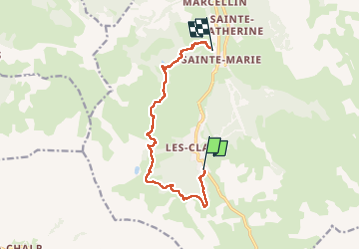
7,2 km | 11 km-effort
3h 30min
![](https://static1.geolcdn.com/siteimages/upload/files/16400158638029165_repeat_loop_refresh_sync_direction_icon.png)
Ja
![Tour Wandern Crévoux - boucle lac du crachet - Photo](https://media.geolcdn.com/t/375/260/ext.jpg?maxdim=2&url=https%3A%2F%2Fservices.sitytrail.com%2FGeolivesWS%2FDownloadMedia.ashx%3FTrailID%3D619371%26Media%3Dfix__20160821105233.jpg)
![Wandern Wandern](https://static1.geolcdn.com/sitytour/trail-icons/101.png)
boucle lac du crachet
Wandern
Schwierig
(1)
Crévoux,
Provence-Alpes-Côte d'Azur,
Hochalpen,
France
![](/images/other/stat-length.png)
10,3 km | 21 km-effort
4h 50min
![](https://static1.geolcdn.com/siteimages/upload/files/16400158638029165_repeat_loop_refresh_sync_direction_icon.png)
Ja
![Tour Wandern Crévoux - PARCOURS DES FEES #7 - Photo](https://media.geolcdn.com/t/375/260/ext.jpg?maxdim=2&url=https%3A%2F%2Fservices.sitytrail.com%2FGeolivesWS%2FDownloadMedia.ashx%3FTrailID%3D606320%26Media%3D812d22bb-a879-4b52-81d0-d1a210f7c536.JPG)
![Wandern Wandern](https://static1.geolcdn.com/sitytour/trail-icons/101.png)
PARCOURS DES FEES #7
Wandern
Medium
(1)
Crévoux,
Provence-Alpes-Côte d'Azur,
Hochalpen,
France
![](/images/other/stat-length.png)
8,3 km | 11,6 km-effort
2h 35min
![](https://static1.geolcdn.com/siteimages/upload/files/16400158638029165_repeat_loop_refresh_sync_direction_icon.png)
Ja
![Tour Wandern Vars - boucle col de Vars - Photo](https://media.geolcdn.com/t/375/260/ext.jpg?maxdim=2&url=https%3A%2F%2Fservices.sitytrail.com%2FGeolivesWS%2FDownloadMedia.ashx%3FTrailID%3D445272%26Media%3Dfix__20150714142947.jpg)
![Wandern Wandern](https://static1.geolcdn.com/sitytour/trail-icons/101.png)
boucle col de Vars
Wandern
Einfach
(2)
Vars,
Provence-Alpes-Côte d'Azur,
Hochalpen,
France
![](/images/other/stat-length.png)
4,5 km | 6,1 km-effort
2h 39min
![](https://static1.geolcdn.com/siteimages/upload/files/16400158638029165_repeat_loop_refresh_sync_direction_icon.png)
Ja
![Tour Wandern Vars - Crêtes de Vars - Photo](https://media.geolcdn.com/t/375/260/ext.jpg?maxdim=2&url=https%3A%2F%2Fservices.sitytrail.com%2FGeolivesWS%2FDownloadMedia.ashx%3FTrailID%3D197621%26Media%3D20130611134031.jpeg)
![Wandern Wandern](https://static1.geolcdn.com/sitytour/trail-icons/101.png)
Crêtes de Vars
Wandern
Medium
(2)
Vars,
Provence-Alpes-Côte d'Azur,
Hochalpen,
France
![](/images/other/stat-length.png)
7,7 km | 14,9 km-effort
4h 0min
![](https://static1.geolcdn.com/siteimages/upload/files/16400158638029165_repeat_loop_refresh_sync_direction_icon.png)
Ja
![Tour Wandern Vars - Tête de Paneyron - Col de Vars - Photo](https://media.geolcdn.com/t/375/260/ext.jpg?maxdim=2&url=https%3A%2F%2Fservices.sitytrail.com%2FGeolivesWS%2FDownloadMedia.ashx%3FTrailID%3D172673%26Media%3D14054_1.jpg)
![Wandern Wandern](https://static1.geolcdn.com/sitytour/trail-icons/101.png)
Tête de Paneyron - Col de Vars
Wandern
Schwierig
(1)
Vars,
Provence-Alpes-Côte d'Azur,
Hochalpen,
France
![](/images/other/stat-length.png)
10 km | 19 km-effort
3h 0min
![](https://static1.geolcdn.com/siteimages/upload/files/16400158638029165_repeat_loop_refresh_sync_direction_icon.png)
Ja
![Tour Wandern Saint-Paul-sur-Ubaye - pointe de l'Eyssina - Photo](https://media.geolcdn.com/t/375/260/f4ffe486-ca5f-4a55-a510-6c4db13d053f.jpg&format=jpg&maxdim=2)
![Wandern Wandern](https://static1.geolcdn.com/sitytour/trail-icons/101.png)
pointe de l'Eyssina
Wandern
Medium
Saint-Paul-sur-Ubaye,
Provence-Alpes-Côte d'Azur,
Alpes-de-Haute-Provence,
France
![](/images/other/stat-length.png)
8,7 km | 18 km-effort
6h 54min
![](https://static1.geolcdn.com/siteimages/upload/files/16400158638029165_repeat_loop_refresh_sync_direction_icon.png)
Nein
![Tour Wandern Vars - Pic de Chabrières 2744m 31.7.22 - Photo](https://media.geolcdn.com/t/375/260/27b448de-709d-4eac-ac4d-b3bdd6c8e895.jpg&format=jpg&maxdim=2)
![Wandern Wandern](https://static1.geolcdn.com/sitytour/trail-icons/101.png)
Pic de Chabrières 2744m 31.7.22
Wandern
Schwierig
Vars,
Provence-Alpes-Côte d'Azur,
Hochalpen,
France
![](/images/other/stat-length.png)
9,7 km | 15,9 km-effort
3h 25min
![](https://static1.geolcdn.com/siteimages/upload/files/16400158638029165_repeat_loop_refresh_sync_direction_icon.png)
Nein
![Tour Wandern Crévoux - Sentier des Fées Crevoux 16/08/18 - Photo](https://media.geolcdn.com/t/375/260/62d5f5b8-1ebc-4b09-a28c-b9abebde2749.jpg&format=jpg&maxdim=2)
![Wandern Wandern](https://static1.geolcdn.com/sitytour/trail-icons/101.png)
Sentier des Fées Crevoux 16/08/18
Wandern
Einfach
Crévoux,
Provence-Alpes-Côte d'Azur,
Hochalpen,
France
![](/images/other/stat-length.png)
6,1 km | 9 km-effort
1h 52min
![](https://static1.geolcdn.com/siteimages/upload/files/16400158638029165_repeat_loop_refresh_sync_direction_icon.png)
Ja