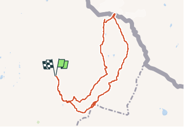
![](/images/other/stat-length.png)
![Tour Wandern Bourg-Saint-Maurice - col des Rousses - Photo](https://media.geolcdn.com/t/1900/400/af69e770-c920-434a-a244-b14f3d62edb0.jpg&format=pjpeg&maxdim=2)
col des Rousses
nadd73
Benutzer GUIDE
![Länge](/images/other/stat-length.png)
![Maximale Höhe](https://static1.geolcdn.com/siteimages/upload/files/1508320355ic_sort_altitude_max_24dp.png)
![Positive Höhendifferenz](https://static1.geolcdn.com/siteimages/upload/files/1508320355ic_sort_den_pos_24dp.png)
![Km-Effort](/images/other/stat-length.png)
![Min. Höhe](https://static1.geolcdn.com/siteimages/upload/files/1508320355ic_sort_altitude_min_24dp.png)
![Negative Höhendifferenz](https://static1.geolcdn.com/siteimages/upload/files/1508320355ic_sort_den_neg_24dp.png)
![Boucle](https://static1.geolcdn.com/siteimages/upload/files/16400158638029165_repeat_loop_refresh_sync_direction_icon.png)
![Wandern](https://static1.geolcdn.com/sitytour/trail-icons/101.png)
4h37
Schwierigkeit : Medium
![Scannen Sie diesen QR-Code, um die Tour in der SityTrail-Anwendung zu öffnen](https://capi.geolives.com/qq0zvz2zws4bq2lad0pu/sitytour/trails/4142119/qr.png?size=200)
Kostenlosegpshiking-Anwendung
Über SityTrail
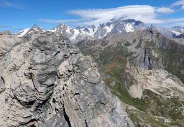
Tour Wandern von 10,5 km verfügbar auf Auvergne-Rhone-Alpen, Savoyen, Bourg-Saint-Maurice. Diese Tour wird von nadd73 vorgeschlagen.
Beschreibung
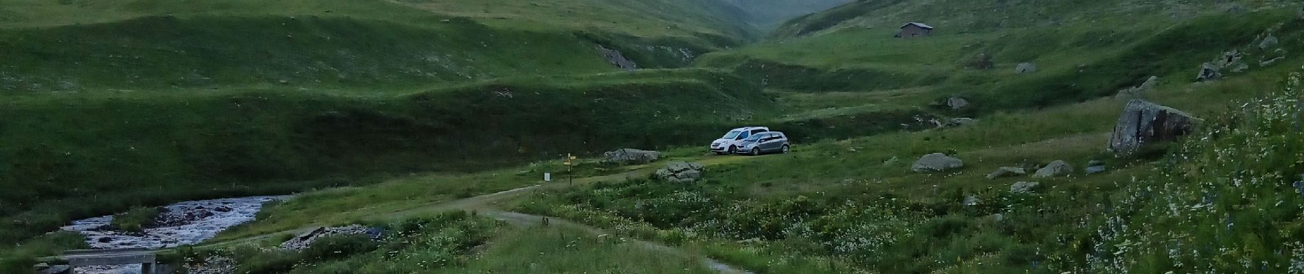
Boucle assez sympathique.
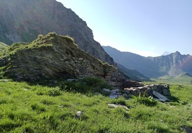
Mais sous aiguille de Beaupré un amas de rochers sinon il faut passer plus sur la crête.
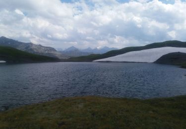
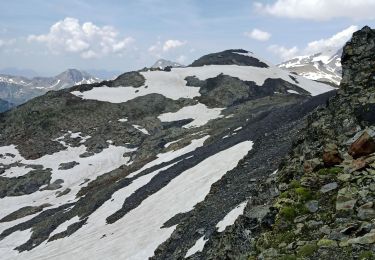
En ce début août 24 il y a encore beaucoup de névés. D'ailleurs à un moment j'ai voulu traverser pour arriver au col mais n'ayant pas de piolet ni crampons, la pente était très raide donc j' ai préféré passer plus bas.
Sinon attention en bas aux patous qui sont plusieurs à garder les moutons. J'ai réussi à passer le torrent assez haut ainsi ils étaient de l'autre côté ☺️.
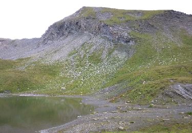
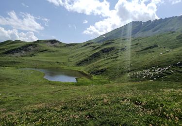
De beaux lacs.
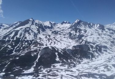
Je n'ai pas eu de vue au col car la brume et le froid m'ont vite fait descendre plus bas.
Ort
Kommentare
Touren in der Umgebung
![Tour Wandern Séez - hospice petit saint Bernard . lac dans fond . la parciere . hospice - Photo](https://media.geolcdn.com/t/375/260/cb23f3b1-848c-4f41-9bcb-bf02580d2bd3.jpg&format=jpg&maxdim=2)
![Wandern Wandern](https://static1.geolcdn.com/sitytour/trail-icons/101.png)
Wandern
![](/images/other/stat-length.png)
![](https://static1.geolcdn.com/siteimages/upload/files/16400158638029165_repeat_loop_refresh_sync_direction_icon.png)
![Tour Wandern Séez - Lancebranlette - Photo](https://media.geolcdn.com/t/375/260/ext.jpg?maxdim=2&url=https%3A%2F%2Fservices.sitytrail.com%2FGeolivesWS%2FDownloadMedia.ashx%3FTrailID%3D798380%26Media%3Dfix__20170729124914.jpg)
![Wandern Wandern](https://static1.geolcdn.com/sitytour/trail-icons/101.png)
Wandern
![](/images/other/stat-length.png)
![](https://static1.geolcdn.com/siteimages/upload/files/16400158638029165_repeat_loop_refresh_sync_direction_icon.png)
![Tour Wandern Bourg-Saint-Maurice - col des Ouillons, pointe 2695 et les grandes aiguilles - Photo](https://media.geolcdn.com/t/375/260/c558e85b-222b-48ae-b68f-d58c96ead386.jpg&format=jpg&maxdim=2)
![Wandern Wandern](https://static1.geolcdn.com/sitytour/trail-icons/101.png)
Wandern
![](/images/other/stat-length.png)
![](https://static1.geolcdn.com/siteimages/upload/files/16400158638029165_repeat_loop_refresh_sync_direction_icon.png)
![Tour Wandern Bourg-Saint-Maurice - col du Breuil et tentative de la pointe de l'Ouillon - Photo](https://media.geolcdn.com/t/375/260/aadc0a03-d638-48fc-8b46-3fd365012c7b.jpg&format=jpg&maxdim=2)
![Wandern Wandern](https://static1.geolcdn.com/sitytour/trail-icons/101.png)
Wandern
![](/images/other/stat-length.png)
![](https://static1.geolcdn.com/siteimages/upload/files/16400158638029165_repeat_loop_refresh_sync_direction_icon.png)
![Tour Wandern Bourg-Saint-Maurice - Le Miravidi et presque l'aiguille de Veis - Photo](https://media.geolcdn.com/t/375/260/492b54a4-3f98-46f8-a6c7-a59e4c43b79b.jpg&format=jpg&maxdim=2)
![Wandern Wandern](https://static1.geolcdn.com/sitytour/trail-icons/101.png)
Wandern
![](/images/other/stat-length.png)
![](https://static1.geolcdn.com/siteimages/upload/files/16400158638029165_repeat_loop_refresh_sync_direction_icon.png)
![Tour Wandern Séez - Lancebranlette avec retour par le Lac sans Fond - Photo](https://media.geolcdn.com/t/375/260/ext.jpg?maxdim=2&url=https%3A%2F%2Fstatic1.geolcdn.com%2Fsiteimages%2Fupload%2Ffiles%2F1553511878bg_sport_marche.png)
![Wandern Wandern](https://static1.geolcdn.com/sitytour/trail-icons/101.png)
Wandern
![](/images/other/stat-length.png)
![](https://static1.geolcdn.com/siteimages/upload/files/16400158638029165_repeat_loop_refresh_sync_direction_icon.png)
![Tour Skiwanderen Bourg-Saint-Maurice - autour du lac de Mya - Photo](https://media.geolcdn.com/t/375/260/4ac04904-2253-423b-b6ac-3f3b6564cfe2.jpg&format=jpg&maxdim=2)
![Skiwanderen Skiwanderen](https://static1.geolcdn.com/sitytour/trail-icons/503.png)
Skiwanderen
![](/images/other/stat-length.png)
![](https://static1.geolcdn.com/siteimages/upload/files/16400158638029165_repeat_loop_refresh_sync_direction_icon.png)
![Tour Skiwanderen Séez - col du Belvédère, le Valezan - Photo](https://media.geolcdn.com/t/375/260/d916e824-8a72-4541-a21a-b355921c434a.jpg&format=jpg&maxdim=2)
![Skiwanderen Skiwanderen](https://static1.geolcdn.com/sitytour/trail-icons/503.png)
Skiwanderen
![](/images/other/stat-length.png)
![](https://static1.geolcdn.com/siteimages/upload/files/16400158638029165_repeat_loop_refresh_sync_direction_icon.png)
![Tour Wandern Séez - lancebranlette et le lac sans fond - Photo](https://media.geolcdn.com/t/375/260/7ff96455-e075-478f-b097-5159a70e10f9.jpg&format=jpg&maxdim=2)
![Wandern Wandern](https://static1.geolcdn.com/sitytour/trail-icons/101.png)
Wandern
![](/images/other/stat-length.png)
![](https://static1.geolcdn.com/siteimages/upload/files/16400158638029165_repeat_loop_refresh_sync_direction_icon.png)