![](/images/other/stat-length.png)
![Tour Elektrofahrrad Schert - VTT - Essert - Salbert - Vétrigne - Miotte - Citadelle Belfort - Essert - Photo](https://media.geolcdn.com/t/1900/400/9ea3754c-f673-4e19-890f-f64e417a9f4d.jpg&format=pjpeg&maxdim=2)
VTT - Essert - Salbert - Vétrigne - Miotte - Citadelle Belfort - Essert
Bart2015
Benutzer
![Länge](/images/other/stat-length.png)
![Maximale Höhe](https://static1.geolcdn.com/siteimages/upload/files/1508320355ic_sort_altitude_max_24dp.png)
![Positive Höhendifferenz](https://static1.geolcdn.com/siteimages/upload/files/1508320355ic_sort_den_pos_24dp.png)
![Km-Effort](/images/other/stat-length.png)
![Min. Höhe](https://static1.geolcdn.com/siteimages/upload/files/1508320355ic_sort_altitude_min_24dp.png)
![Negative Höhendifferenz](https://static1.geolcdn.com/siteimages/upload/files/1508320355ic_sort_den_neg_24dp.png)
![Boucle](https://static1.geolcdn.com/siteimages/upload/files/16400158638029165_repeat_loop_refresh_sync_direction_icon.png)
![Elektrofahrrad](https://static1.geolcdn.com/sitytour/trail-icons/205.png)
4h55
Schwierigkeit : Schwierig
![Scannen Sie diesen QR-Code, um die Tour in der SityTrail-Anwendung zu öffnen](https://capi.geolives.com/qq0zvz2zws4bq2lad0pu/sitytour/trails/4133356/qr.png?size=200)
Kostenlosegpshiking-Anwendung
Über SityTrail
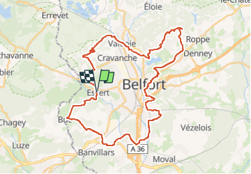
Tour Elektrofahrrad von 42 km verfügbar auf Burgund und Freigrafschaft, Territoire-de-Belfort, Schert. Diese Tour wird von Bart2015 vorgeschlagen.
Beschreibung
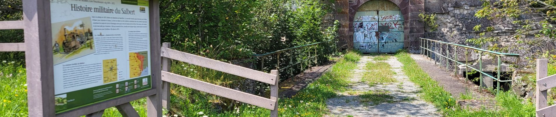
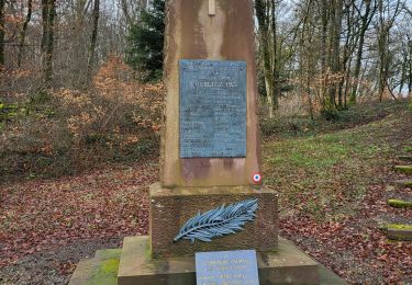
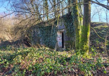
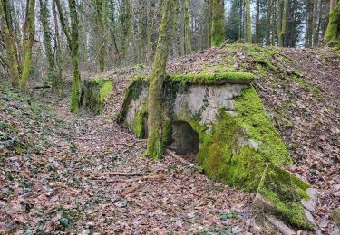
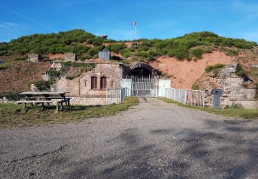
Petite randonnée des forts à VTT (électrique) au départ d'Essert. Passage par les forts du Salbert, de la Miotte, de la Justice, la citadelle de Belfort, de la Côte.
Les chemins sont parfois techniques : partie Miotte - citadelle où il faut parfois descendre de vélo mais c'est magnifique ...
Bonne rando, soyez prudent et respectueux des piétons que vous pourriez rencontrer ...
Ort
Kommentare
Touren in der Umgebung
![Tour Mountainbike Andelnach - Tour d'Essert - Photo](https://media.geolcdn.com/t/375/260/ext.jpg?maxdim=2&url=https%3A%2F%2Fstatic1.geolcdn.com%2Fsiteimages%2Fupload%2Ffiles%2F1524743154velo.jpg)
![Mountainbike Mountainbike](https://static1.geolcdn.com/sitytour/trail-icons/202.png)
Mountainbike
![](/images/other/stat-length.png)
![](https://static1.geolcdn.com/siteimages/upload/files/16400158638029165_repeat_loop_refresh_sync_direction_icon.png)
![Tour Wandern Belfort - Offemont - La ballade des Champs Cerisiers - Photo](https://media.geolcdn.com/t/375/260/ext.jpg?maxdim=2&url=https%3A%2F%2Fstatic1.geolcdn.com%2Fsiteimages%2Fupload%2Ffiles%2F1553511878bg_sport_marche.png)
![Wandern Wandern](https://static1.geolcdn.com/sitytour/trail-icons/101.png)
Wandern
![](/images/other/stat-length.png)
![](https://static1.geolcdn.com/siteimages/upload/files/16400158638029165_repeat_loop_refresh_sync_direction_icon.png)
![Tour Wandern Offemundt - Etang des Forges - Forts de la Miotte et de la Justice - Citadèle et Vieille ville de Belfort - Photo](https://media.geolcdn.com/t/375/260/c26a3ad7-a095-475f-934e-c91591fd50e4.jpg&format=jpg&maxdim=2)
![Wandern Wandern](https://static1.geolcdn.com/sitytour/trail-icons/101.png)
Wandern
![](/images/other/stat-length.png)
![](https://static1.geolcdn.com/siteimages/upload/files/16400158638029165_repeat_loop_refresh_sync_direction_icon.png)
![Tour Elektrofahrrad Châlonvillars - VTT - Châlonvillars - Etobon - Ronchamp - Plancher-Bas - Malsaucy - Photo](https://media.geolcdn.com/t/375/260/0af5e710-b661-426e-a32c-4cb272df7c44.jpg&format=jpg&maxdim=2)
![Elektrofahrrad Elektrofahrrad](https://static1.geolcdn.com/sitytour/trail-icons/205.png)
Elektrofahrrad
![](/images/other/stat-length.png)
![](https://static1.geolcdn.com/siteimages/upload/files/16400158638029165_repeat_loop_refresh_sync_direction_icon.png)
![Tour Wandern Banvillars - Banvillars - forts du Hauts Bois et du Bois d'Oye - Photo](https://media.geolcdn.com/t/375/260/88f0967b-6ffd-4876-9f84-18be058a8f3f.jpg&format=jpg&maxdim=2)
![Wandern Wandern](https://static1.geolcdn.com/sitytour/trail-icons/101.png)
Wandern
![](/images/other/stat-length.png)
![](https://static1.geolcdn.com/siteimages/upload/files/16400158638029165_repeat_loop_refresh_sync_direction_icon.png)
![Tour Wandern Mandrevillars - Echenans et son fort - Photo](https://media.geolcdn.com/t/375/260/f507e7d6-76e6-4d94-8c38-4bcdb3990215.jpg&format=jpg&maxdim=2)
![Wandern Wandern](https://static1.geolcdn.com/sitytour/trail-icons/101.png)
Wandern
![](/images/other/stat-length.png)
![](https://static1.geolcdn.com/siteimages/upload/files/16400158638029165_repeat_loop_refresh_sync_direction_icon.png)
![Tour Wandern Sevenans - Randonnée des forts depuis Sévenans - Photo](https://media.geolcdn.com/t/375/260/f60b66f1-29f9-4bb6-9be8-f56ded01ac55.jpg&format=jpg&maxdim=2)
![Wandern Wandern](https://static1.geolcdn.com/sitytour/trail-icons/101.png)
Wandern
![](/images/other/stat-length.png)
![](https://static1.geolcdn.com/siteimages/upload/files/16400158638029165_repeat_loop_refresh_sync_direction_icon.png)
![Tour Wandern Châlonvillars - Châlonvillars - Fort du Salbert - Evette-Salbert - Photo](https://media.geolcdn.com/t/375/260/30a56d40-1ac0-4227-a497-f489c67ce1fe.jpg&format=jpg&maxdim=2)
![Wandern Wandern](https://static1.geolcdn.com/sitytour/trail-icons/101.png)
Wandern
![](/images/other/stat-length.png)
![](https://static1.geolcdn.com/siteimages/upload/files/16400158638029165_repeat_loop_refresh_sync_direction_icon.png)
![Tour Mountainbike Châlonvillars - Châlonvillars - Fort Giromagny en passant au milieu des étangs - Photo](https://media.geolcdn.com/t/375/260/4cf742f1-48e3-4bef-b8af-82a52a583623.jpg&format=jpg&maxdim=2)
![Mountainbike Mountainbike](https://static1.geolcdn.com/sitytour/trail-icons/202.png)
Mountainbike
![](/images/other/stat-length.png)
![](https://static1.geolcdn.com/siteimages/upload/files/16400158638029165_repeat_loop_refresh_sync_direction_icon.png)