![](/images/other/stat-length.png)
![Tour Wandern Hauts de Bienne - Le trou bleu Morez - Photo](https://media.geolcdn.com/t/1900/400/e23a6b37-cdb0-48a0-b705-768166bf0ed4.jpg&format=pjpeg&maxdim=2)
Le trou bleu Morez
Mady Lambert
Benutzer
![Länge](/images/other/stat-length.png)
Länge
5,5 km
![Maximale Höhe](https://static1.geolcdn.com/siteimages/upload/files/1508320355ic_sort_altitude_max_24dp.png)
Maximale Höhe
774 m
![Positive Höhendifferenz](https://static1.geolcdn.com/siteimages/upload/files/1508320355ic_sort_den_pos_24dp.png)
Positive Höhendifferenz
170 m
![Km-Effort](/images/other/stat-length.png)
Km-Effort
7,5 km
![Min. Höhe](https://static1.geolcdn.com/siteimages/upload/files/1508320355ic_sort_altitude_min_24dp.png)
Min. Höhe
681 m
![Negative Höhendifferenz](https://static1.geolcdn.com/siteimages/upload/files/1508320355ic_sort_den_neg_24dp.png)
Negative Höhendifferenz
98 m
![Boucle](https://static1.geolcdn.com/siteimages/upload/files/16400158638029165_repeat_loop_refresh_sync_direction_icon.png)
Boucle
Nein
Erstellungsdatum :
2024-07-13 13:02:06.77
Letzte Änderung :
2024-07-13 14:44:29.901
![Wandern](https://static1.geolcdn.com/sitytour/trail-icons/101.png)
1h08
Schwierigkeit : Medium
![Scannen Sie diesen QR-Code, um die Tour in der SityTrail-Anwendung zu öffnen](https://capi.geolives.com/qq0zvz2zws4bq2lad0pu/sitytour/trails/4120672/qr.png?size=200)
Kostenlosegpshiking-Anwendung
Über SityTrail
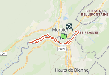
Tour Wandern von 5,5 km verfügbar auf Burgund und Freigrafschaft, Jura, Hauts de Bienne. Diese Tour wird von Mady Lambert vorgeschlagen.
Beschreibung
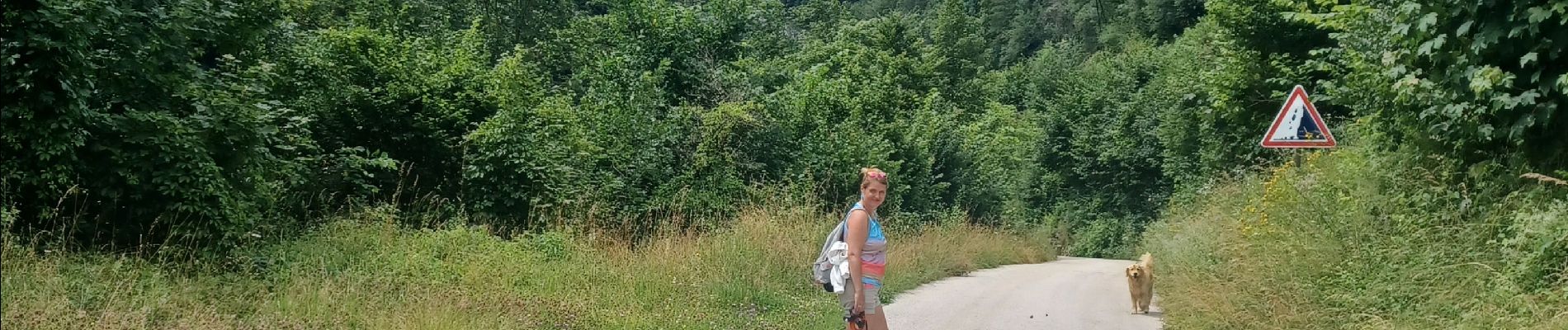
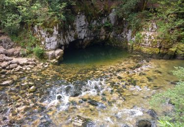
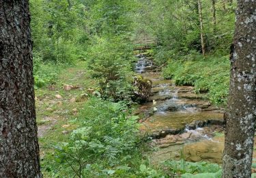
Tour le long de la Bienne, passage sur les ponts de singe, sentiers pédagogiques, bonnes chaussures indispensables.
Ort
Land:
France
Region :
Burgund und Freigrafschaft
Abteilung/Provinz :
Jura
Kommune :
Hauts de Bienne
Standort:
Morez
Gehen Sie:(Dec)
Gehen Sie:(UTM)
271207 ; 5157381 (32T) N.
Kommentare
Touren in der Umgebung
![Tour Schneeschuhwandern Les Rousses - Lac des Rousses - Photo](https://media.geolcdn.com/t/375/260/ext.jpg?maxdim=2&url=https%3A%2F%2Fstatic1.geolcdn.com%2Fsiteimages%2Fupload%2Ffiles%2F1524743153raquette.jpg)
![Schneeschuhwandern Schneeschuhwandern](https://static1.geolcdn.com/sitytour/trail-icons/504.png)
Lac des Rousses
Schneeschuhwandern
Medium
(1)
Les Rousses,
Burgund und Freigrafschaft,
Jura,
France
![](/images/other/stat-length.png)
13,8 km | 18,4 km-effort
4h 15min
![](https://static1.geolcdn.com/siteimages/upload/files/16400158638029165_repeat_loop_refresh_sync_direction_icon.png)
Ja
![Tour Elektrofahrrad Saint-Laurent-en-Grandvaux - 030824 - Photo](https://media.geolcdn.com/t/375/260/ext.jpg?maxdim=2&url=https%3A%2F%2Fstatic1.geolcdn.com%2Fsiteimages%2Fupload%2Ffiles%2F1524743154velo.jpg)
![Elektrofahrrad Elektrofahrrad](https://static1.geolcdn.com/sitytour/trail-icons/205.png)
030824
Elektrofahrrad
Medium
(1)
Saint-Laurent-en-Grandvaux,
Burgund und Freigrafschaft,
Jura,
France
![](/images/other/stat-length.png)
49 km | 61 km-effort
Unbekannt
![](https://static1.geolcdn.com/siteimages/upload/files/16400158638029165_repeat_loop_refresh_sync_direction_icon.png)
Ja
![Tour Wandern Les Rousses - lac des rousses . roche blanche . fort du risoux - Photo](https://media.geolcdn.com/t/375/260/35569d80-7092-45c8-a9d4-39991b8597b1.jpg&format=jpg&maxdim=2)
![Wandern Wandern](https://static1.geolcdn.com/sitytour/trail-icons/101.png)
lac des rousses . roche blanche . fort du risoux
Wandern
Einfach
Les Rousses,
Burgund und Freigrafschaft,
Jura,
France
![](/images/other/stat-length.png)
10,2 km | 14,1 km-effort
4h 20min
![](https://static1.geolcdn.com/siteimages/upload/files/16400158638029165_repeat_loop_refresh_sync_direction_icon.png)
Ja
![Tour Wandern Les Rousses - Lac](https://media.geolcdn.com/t/375/260/9e55edf2-a12a-4787-80b5-69f110e65d81.jpg&format=jpg&maxdim=2)
![Wandern Wandern](https://static1.geolcdn.com/sitytour/trail-icons/101.png)
Lac "Les Rousses", Fort du Risoux, Belvédère de Lavenna
Wandern
Schwierig
Les Rousses,
Burgund und Freigrafschaft,
Jura,
France
![](/images/other/stat-length.png)
27 km | 37 km-effort
3h 2min
![](https://static1.geolcdn.com/siteimages/upload/files/16400158638029165_repeat_loop_refresh_sync_direction_icon.png)
Nein
![Tour Wandern Hauts de Bienne - Le Trou Bleu 11.7.23 - Photo](https://media.geolcdn.com/t/375/260/32941ccf-bc70-4062-9de5-a6e8a257842a.jpg&format=jpg&maxdim=2)
![Wandern Wandern](https://static1.geolcdn.com/sitytour/trail-icons/101.png)
Le Trou Bleu 11.7.23
Wandern
Einfach
Hauts de Bienne,
Burgund und Freigrafschaft,
Jura,
France
![](/images/other/stat-length.png)
3,9 km | 5,3 km-effort
1h 15min
![](https://static1.geolcdn.com/siteimages/upload/files/16400158638029165_repeat_loop_refresh_sync_direction_icon.png)
Ja
![Tour Wandern Bellefontaine - Pichonnier-Peraillet- village par l'Évalude - Photo](https://media.geolcdn.com/t/375/260/a5d97e4a-8813-4957-9f75-ff2855599f4e.jpg&format=jpg&maxdim=2)
![Wandern Wandern](https://static1.geolcdn.com/sitytour/trail-icons/101.png)
Pichonnier-Peraillet- village par l'Évalude
Wandern
Schwierig
Bellefontaine,
Burgund und Freigrafschaft,
Jura,
France
![](/images/other/stat-length.png)
5,4 km | 7,5 km-effort
1h 53min
![](https://static1.geolcdn.com/siteimages/upload/files/16400158638029165_repeat_loop_refresh_sync_direction_icon.png)
Ja
![Tour Wandern Bellefontaine - Des lacs de Bellefontaine vers le belvédère de la roche Bernard. - Photo](https://media.geolcdn.com/t/375/260/4c61fcfd-b428-4bd3-b76a-55bf7607b035.jpg&format=jpg&maxdim=2)
![Wandern Wandern](https://static1.geolcdn.com/sitytour/trail-icons/101.png)
Des lacs de Bellefontaine vers le belvédère de la roche Bernard.
Wandern
Schwierig
Bellefontaine,
Burgund und Freigrafschaft,
Jura,
France
![](/images/other/stat-length.png)
5,8 km | 8,7 km-effort
1h 53min
![](https://static1.geolcdn.com/siteimages/upload/files/16400158638029165_repeat_loop_refresh_sync_direction_icon.png)
Ja
![Tour Radtourismus Les Rousses - LES ROUSSES - SAINT CLAUDE - Photo](https://media.geolcdn.com/t/375/260/928f2241-0f9f-4acc-bcc3-a160a7177835.jpg&format=jpg&maxdim=2)
![Radtourismus Radtourismus](https://static1.geolcdn.com/sitytour/trail-icons/204.png)
LES ROUSSES - SAINT CLAUDE
Radtourismus
Schwierig
Les Rousses,
Burgund und Freigrafschaft,
Jura,
France
![](/images/other/stat-length.png)
69 km | 88 km-effort
6h 15min
![](https://static1.geolcdn.com/siteimages/upload/files/16400158638029165_repeat_loop_refresh_sync_direction_icon.png)
Nein
![Tour Radtourismus Les Rousses - LES ROUSSES - PARCOURS EST VERS LA SUISSE - Photo](https://media.geolcdn.com/t/375/260/eeb74120-26ed-40de-8ac2-cf62da8cb8cd.jpg&format=jpg&maxdim=2)
![Radtourismus Radtourismus](https://static1.geolcdn.com/sitytour/trail-icons/204.png)
LES ROUSSES - PARCOURS EST VERS LA SUISSE
Radtourismus
Schwierig
Les Rousses,
Burgund und Freigrafschaft,
Jura,
France
![](/images/other/stat-length.png)
67 km | 85 km-effort
7h 18min
![](https://static1.geolcdn.com/siteimages/upload/files/16400158638029165_repeat_loop_refresh_sync_direction_icon.png)
Ja
Randonnée incorrecte, elle ne correspond pas au tracé effectué réellement et qui faisait un peu plus de 3,5 km avec points de départ et d'arrivée identiques