![](/images/other/stat-length.png)
![Tour Wandern Plouha - Plouha Plage Bonaparte - GR34 Chapelle Saint-Marc - 22.9km 465m 5h20 (35mn) - 2024 07 02 - Photo](https://media.geolcdn.com/t/1900/400/ext.pjpeg?maxdim=2&url=https%3A%2F%2Fmedia.geolcdn.com%2Ff%2Fbcacf27c-29c4-44ac-9acd-40f1f30e3463.jpg)
Plouha Plage Bonaparte - GR34 Chapelle Saint-Marc - 22.9km 465m 5h20 (35mn) - 2024 07 02
Orcal37
Benutzer GUIDE
![Länge](/images/other/stat-length.png)
Länge
23 km
![Maximale Höhe](https://static1.geolcdn.com/siteimages/upload/files/1508320355ic_sort_altitude_max_24dp.png)
Maximale Höhe
108 m
![Positive Höhendifferenz](https://static1.geolcdn.com/siteimages/upload/files/1508320355ic_sort_den_pos_24dp.png)
Positive Höhendifferenz
467 m
![Km-Effort](/images/other/stat-length.png)
Km-Effort
29 km
![Min. Höhe](https://static1.geolcdn.com/siteimages/upload/files/1508320355ic_sort_altitude_min_24dp.png)
Min. Höhe
1 m
![Negative Höhendifferenz](https://static1.geolcdn.com/siteimages/upload/files/1508320355ic_sort_den_neg_24dp.png)
Negative Höhendifferenz
467 m
![Boucle](https://static1.geolcdn.com/siteimages/upload/files/16400158638029165_repeat_loop_refresh_sync_direction_icon.png)
Boucle
Ja
Erstellungsdatum :
2024-07-02 11:28:56.336
Letzte Änderung :
2024-07-07 15:00:03.244
![Wandern](https://static1.geolcdn.com/sitytour/trail-icons/101.png)
5h20
Schwierigkeit : Schwierig
![Scannen Sie diesen QR-Code, um die Tour in der SityTrail-Anwendung zu öffnen](https://capi.geolives.com/qq0zvz2zws4bq2lad0pu/sitytour/trails/4109904/qr.png?size=200)
Kostenlosegpshiking-Anwendung
Über SityTrail
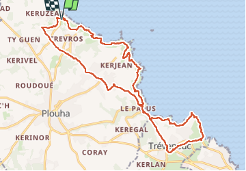
Tour Wandern von 23 km verfügbar auf Bretagne, Côtes-d'Armor, Plouha. Diese Tour wird von Orcal37 vorgeschlagen.
Beschreibung
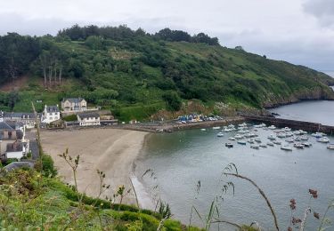
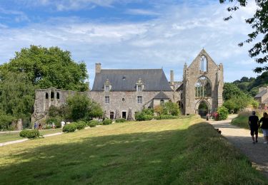
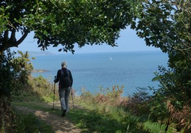
Plouha Plage Bonaparte - GR34 - Chapelle Saint-Marc - 22.9km 465m 5h20 (35mn) - 2024 07 02
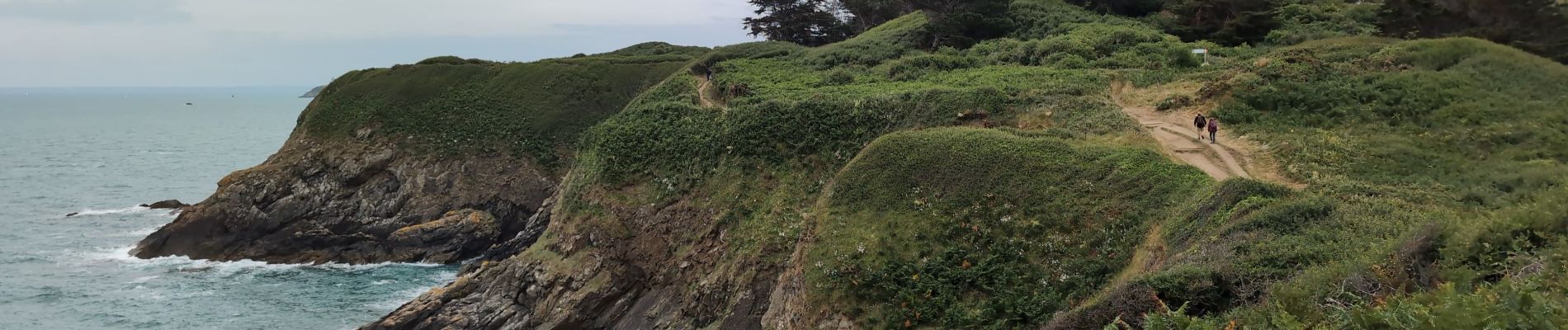
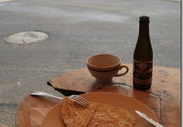
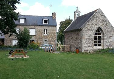
Ort
Land:
France
Region :
Bretagne
Abteilung/Provinz :
Côtes-d'Armor
Kommune :
Plouha
Standort:
Unknown
Gehen Sie:(Dec)
Gehen Sie:(UTM)
505516 ; 5394857 (30U) N.
Kommentare
Touren in der Umgebung
![Tour Wandern Lanloup - Pointe de la Tour - Lanloup - Photo](https://media.geolcdn.com/t/375/260/ext.jpg?maxdim=2&url=https%3A%2F%2Fservices.sitytrail.com%2FGeolivesWS%2FDownloadMedia.ashx%3FTrailID%3D317022%26Media%3D16164_6.jpg)
![Wandern Wandern](https://static1.geolcdn.com/sitytour/trail-icons/101.png)
Pointe de la Tour - Lanloup
Wandern
Medium
(1)
Lanloup,
Bretagne,
Côtes-d'Armor,
France
![](/images/other/stat-length.png)
11,2 km | 15,4 km-effort
3h 0min
![](https://static1.geolcdn.com/siteimages/upload/files/16400158638029165_repeat_loop_refresh_sync_direction_icon.png)
Ja
![Tour Wandern Plouha - circuit danse macabre Kermaria - Photo](https://media.geolcdn.com/t/375/260/ext.jpg?maxdim=2&url=https%3A%2F%2Fmedia.geolcdn.com%2Ff%2F98e4016a-bbb4-4548-9d94-d28bcef934d6.jpg)
![Wandern Wandern](https://static1.geolcdn.com/sitytour/trail-icons/101.png)
circuit danse macabre Kermaria
Wandern
Sehr leicht
(1)
Plouha,
Bretagne,
Côtes-d'Armor,
France
![](/images/other/stat-length.png)
11,9 km | 13 km-effort
2h 44min
![](https://static1.geolcdn.com/siteimages/upload/files/16400158638029165_repeat_loop_refresh_sync_direction_icon.png)
Ja
![Tour Wandern Plouha - GR_34_CG_20_Plouha_Plouezec_20240528 - Photo](https://media.geolcdn.com/t/375/260/ext.jpg?maxdim=2&url=https%3A%2F%2Fmedia.geolcdn.com%2Ff%2F1c219358-8314-48f4-beed-23d75278c8e8.jpg)
![Wandern Wandern](https://static1.geolcdn.com/sitytour/trail-icons/101.png)
GR_34_CG_20_Plouha_Plouezec_20240528
Wandern
Medium
Plouha,
Bretagne,
Côtes-d'Armor,
France
![](/images/other/stat-length.png)
12,2 km | 16,5 km-effort
3h 26min
![](https://static1.geolcdn.com/siteimages/upload/files/16400158638029165_repeat_loop_refresh_sync_direction_icon.png)
Nein
![Tour Wandern Plouha - Falaises de Plouha 9.7.23 - Photo](https://media.geolcdn.com/t/375/260/ext.jpg?maxdim=2&url=https%3A%2F%2Fmedia.geolcdn.com%2Ff%2Fde6227f9-1985-40a8-bc72-346614fcac6d.jpg)
![Wandern Wandern](https://static1.geolcdn.com/sitytour/trail-icons/101.png)
Falaises de Plouha 9.7.23
Wandern
Einfach
Plouha,
Bretagne,
Côtes-d'Armor,
France
![](/images/other/stat-length.png)
14,8 km | 20 km-effort
2h 50min
![](https://static1.geolcdn.com/siteimages/upload/files/16400158638029165_repeat_loop_refresh_sync_direction_icon.png)
Nein
![Tour Wandern Lanloup - GR34 Brehec-Kerity - Photo](https://media.geolcdn.com/t/375/260/ext.jpg?maxdim=2&url=https%3A%2F%2Fmedia.geolcdn.com%2Ff%2Ff43542fd-4bb4-4181-bb6b-7c4ea0863ea1.jpg)
![Wandern Wandern](https://static1.geolcdn.com/sitytour/trail-icons/101.png)
GR34 Brehec-Kerity
Wandern
Medium
Lanloup,
Bretagne,
Côtes-d'Armor,
France
![](/images/other/stat-length.png)
19,2 km | 25 km-effort
5h 30min
![](https://static1.geolcdn.com/siteimages/upload/files/16400158638029165_repeat_loop_refresh_sync_direction_icon.png)
Nein
![Tour Zu Fuß Plouha - Les Trois Chapelles - Photo](https://media.geolcdn.com/t/375/260/ext.jpg?maxdim=2&url=https%3A%2F%2Fmedia.geolcdn.com%2Ff%2F9df4f58f-9bc5-4b98-9444-d236d8a979ac.jpeg)
![Zu Fuß Zu Fuß](https://static1.geolcdn.com/sitytour/trail-icons/100.png)
Les Trois Chapelles
Zu Fuß
Einfach
Plouha,
Bretagne,
Côtes-d'Armor,
France
![](/images/other/stat-length.png)
7,6 km | 8,4 km-effort
1h 54min
![](https://static1.geolcdn.com/siteimages/upload/files/16400158638029165_repeat_loop_refresh_sync_direction_icon.png)
Ja
![Tour Zu Fuß Pludual - Le Bocage - Photo](https://media.geolcdn.com/t/375/260/ext.jpg?maxdim=2&url=https%3A%2F%2Fmedia.geolcdn.com%2Ff%2F9df4f58f-9bc5-4b98-9444-d236d8a979ac.jpeg)
![Zu Fuß Zu Fuß](https://static1.geolcdn.com/sitytour/trail-icons/100.png)
![Tour Wandern Plouha - plouha plage Bonaparte 5km - Photo](https://media.geolcdn.com/t/375/260/ext.jpg?maxdim=2&url=https%3A%2F%2Fmedia.geolcdn.com%2Ff%2F78cdae15-3218-4374-930c-e7dd702ed49a.jpg)
![Wandern Wandern](https://static1.geolcdn.com/sitytour/trail-icons/101.png)
plouha plage Bonaparte 5km
Wandern
Sehr schwierig
Plouha,
Bretagne,
Côtes-d'Armor,
France
![](/images/other/stat-length.png)
24 km | 28 km-effort
3h 6min
![](https://static1.geolcdn.com/siteimages/upload/files/16400158638029165_repeat_loop_refresh_sync_direction_icon.png)
Nein
![Tour Wandern Plouha - Falaises de Plouha - Photo](https://media.geolcdn.com/t/375/260/ext.jpg?maxdim=2&url=https%3A%2F%2Fmedia.geolcdn.com%2Ff%2Fbb9a28d7-b651-4d0a-8536-b1b30fd406c9.JPG)
![Wandern Wandern](https://static1.geolcdn.com/sitytour/trail-icons/101.png)
Falaises de Plouha
Wandern
Medium
Plouha,
Bretagne,
Côtes-d'Armor,
France
![](/images/other/stat-length.png)
16,2 km | 21 km-effort
5h 44min
![](https://static1.geolcdn.com/siteimages/upload/files/16400158638029165_repeat_loop_refresh_sync_direction_icon.png)
Ja