![](/images/other/stat-length.png)
![Tour Wandern Rochefort - Montgauthier - Photo](https://media.geolcdn.com/t/1900/400/ext.pjpeg?maxdim=2&url=https%3A%2F%2Fmedia.geolcdn.com%2Ff%2F1c1e3c3f-bf1b-45e1-ab62-363ea7079ac2.jpg)
Montgauthier
BrigitteBertrand
Benutzer
![Länge](/images/other/stat-length.png)
Länge
13,8 km
![Maximale Höhe](https://static1.geolcdn.com/siteimages/upload/files/1508320355ic_sort_altitude_max_24dp.png)
Maximale Höhe
309 m
![Positive Höhendifferenz](https://static1.geolcdn.com/siteimages/upload/files/1508320355ic_sort_den_pos_24dp.png)
Positive Höhendifferenz
266 m
![Km-Effort](/images/other/stat-length.png)
Km-Effort
17,3 km
![Min. Höhe](https://static1.geolcdn.com/siteimages/upload/files/1508320355ic_sort_altitude_min_24dp.png)
Min. Höhe
199 m
![Negative Höhendifferenz](https://static1.geolcdn.com/siteimages/upload/files/1508320355ic_sort_den_neg_24dp.png)
Negative Höhendifferenz
264 m
![Boucle](https://static1.geolcdn.com/siteimages/upload/files/16400158638029165_repeat_loop_refresh_sync_direction_icon.png)
Boucle
Ja
Erstellungsdatum :
2024-06-30 11:19:19.0
Letzte Änderung :
2024-07-01 17:09:21.839
![Wandern](https://static1.geolcdn.com/sitytour/trail-icons/101.png)
3h55
Schwierigkeit : Schwierig
![Scannen Sie diesen QR-Code, um die Tour in der SityTrail-Anwendung zu öffnen](https://capi.geolives.com/qq0zvz2zws4bq2lad0pu/sitytour/trails/4107740/qr.png?size=200)
Kostenlosegpshiking-Anwendung
Über SityTrail
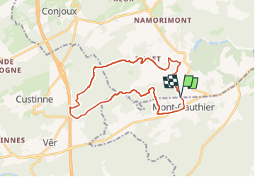
Tour Wandern von 13,8 km verfügbar auf Wallonien, Namur, Rochefort. Diese Tour wird von BrigitteBertrand vorgeschlagen.
Beschreibung
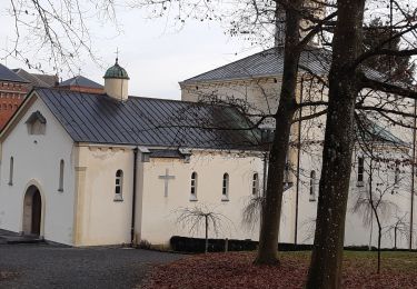
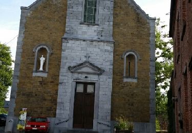
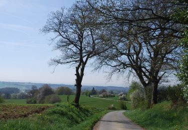
Vers Chevetogne, du haut ...Enhet, puis la tombe du loup.. du bas en longeant l'Ywoigne. Remontée ensuite vers le village et la rue des Grêlons
Ort
Land:
Belgium
Region :
Wallonien
Abteilung/Provinz :
Namur
Kommune :
Rochefort
Standort:
Unknown
Gehen Sie:(Dec)
Gehen Sie:(UTM)
651231 ; 5564380 (31U) N.
Kommentare
Touren in der Umgebung
![Tour Wandern Ciney - CINEY- Chevetogne- Promenade de l'Ywoigne - Photo](https://media.geolcdn.com/t/375/260/ext.jpg?maxdim=2&url=https%3A%2F%2Fservices.sitytrail.com%2FGeolivesWS%2FDownloadMedia.ashx%3FTrailID%3D250674%26Media%3D8a32e342-1555-4b9f-9653-7b95be5cb295.jpg)
![Wandern Wandern](https://static1.geolcdn.com/sitytour/trail-icons/101.png)
CINEY- Chevetogne- Promenade de l'Ywoigne
Wandern
Sehr leicht
(9)
Ciney,
Wallonien,
Namur,
Belgium
![](/images/other/stat-length.png)
5 km | 6,5 km-effort
1h 22min
![](https://static1.geolcdn.com/siteimages/upload/files/16400158638029165_repeat_loop_refresh_sync_direction_icon.png)
Ja
![Tour Wandern Ciney - CINEY- Chevetogne- Promenade du Tige de Ronvaux - Photo](https://media.geolcdn.com/t/375/260/ext.jpg?maxdim=2&url=https%3A%2F%2Fservices.sitytrail.com%2FGeolivesWS%2FDownloadMedia.ashx%3FTrailID%3D250673%26Media%3D8a32e342-1555-4b9f-9653-7b95be5cb295.jpg)
![Wandern Wandern](https://static1.geolcdn.com/sitytour/trail-icons/101.png)
CINEY- Chevetogne- Promenade du Tige de Ronvaux
Wandern
Medium
(6)
Ciney,
Wallonien,
Namur,
Belgium
![](/images/other/stat-length.png)
10,5 km | 13,2 km-effort
2h 50min
![](https://static1.geolcdn.com/siteimages/upload/files/16400158638029165_repeat_loop_refresh_sync_direction_icon.png)
Ja
![Tour Wandern Houyet - Balade à Ciergnon. - Photo](https://media.geolcdn.com/t/375/260/ext.jpg?maxdim=2&url=https%3A%2F%2Fmedia.geolcdn.com%2Ff%2Fd2dc29f5-7370-4a3a-abe2-c70a31b1a75f.jpg)
![Wandern Wandern](https://static1.geolcdn.com/sitytour/trail-icons/101.png)
Balade à Ciergnon.
Wandern
Sehr leicht
(3)
Houyet,
Wallonien,
Namur,
Belgium
![](/images/other/stat-length.png)
10,8 km | 14 km-effort
4h 44min
![](https://static1.geolcdn.com/siteimages/upload/files/16400158638029165_repeat_loop_refresh_sync_direction_icon.png)
Ja
![Tour Wandern Ciney - chevetogne ac 2 - Photo](https://media.geolcdn.com/t/375/260/ext.jpg?maxdim=2&url=https%3A%2F%2Fmedia.geolcdn.com%2Ff%2Fbce6b811-b90d-4ac9-9c30-184ef4de226e.jpg)
![Wandern Wandern](https://static1.geolcdn.com/sitytour/trail-icons/101.png)
chevetogne ac 2
Wandern
Einfach
(1)
Ciney,
Wallonien,
Namur,
Belgium
![](/images/other/stat-length.png)
9,7 km | 12,2 km-effort
3h 19min
![](https://static1.geolcdn.com/siteimages/upload/files/16400158638029165_repeat_loop_refresh_sync_direction_icon.png)
Ja
![Tour Wandern Ciney - CHEVETOGNE (village) - Photo](https://media.geolcdn.com/t/375/260/ext.jpg?maxdim=2&url=https%3A%2F%2Fservices.sitytrail.com%2FGeolivesWS%2FDownloadMedia.ashx%3FTrailID%3D460046%26Media%3Dfix__20150816101035.jpg)
![Wandern Wandern](https://static1.geolcdn.com/sitytour/trail-icons/101.png)
CHEVETOGNE (village)
Wandern
Einfach
(3)
Ciney,
Wallonien,
Namur,
Belgium
![](/images/other/stat-length.png)
10,4 km | 12,5 km-effort
2h 43min
![](https://static1.geolcdn.com/siteimages/upload/files/16400158638029165_repeat_loop_refresh_sync_direction_icon.png)
Ja
![Tour Wandern Ciney - CINEY- Conjoux- Promenade du Tilleul de Conjoux - Photo](https://media.geolcdn.com/t/375/260/ext.jpg?maxdim=2&url=https%3A%2F%2Fservices.sitytrail.com%2FGeolivesWS%2FDownloadMedia.ashx%3FTrailID%3D250678%26Media%3D35afc09f-bf4c-4284-baa5-6441c5e98513.jpg)
![Wandern Wandern](https://static1.geolcdn.com/sitytour/trail-icons/101.png)
CINEY- Conjoux- Promenade du Tilleul de Conjoux
Wandern
Sehr leicht
(5)
Ciney,
Wallonien,
Namur,
Belgium
![](/images/other/stat-length.png)
8,5 km | 10,8 km-effort
2h 22min
![](https://static1.geolcdn.com/siteimages/upload/files/16400158638029165_repeat_loop_refresh_sync_direction_icon.png)
Ja
![Tour Wandern Houyet - HOUYET-HEROCK*-Les paysages de la Lesse moyenne (raccourci) - Photo](https://media.geolcdn.com/t/375/260/ext.jpg?maxdim=2&url=https%3A%2F%2Fmedia.geolcdn.com%2Ff%2Fb6da13b0-fa0a-4c94-8e33-3fbb13236e85.jpg)
![Wandern Wandern](https://static1.geolcdn.com/sitytour/trail-icons/101.png)
HOUYET-HEROCK*-Les paysages de la Lesse moyenne (raccourci)
Wandern
Schwierig
(1)
Houyet,
Wallonien,
Namur,
Belgium
![](/images/other/stat-length.png)
8,8 km | 11,3 km-effort
3h 14min
![](https://static1.geolcdn.com/siteimages/upload/files/16400158638029165_repeat_loop_refresh_sync_direction_icon.png)
Ja
![Tour Wandern Houyet - HOUYET-HEROCK*-Les paysages de la Lesse moyenne - Photo](https://media.geolcdn.com/t/375/260/ext.jpg?maxdim=2&url=https%3A%2F%2Fstatic1.geolcdn.com%2Fsiteimages%2Fupload%2Ffiles%2F1553511878bg_sport_marche.png)
![Wandern Wandern](https://static1.geolcdn.com/sitytour/trail-icons/101.png)
HOUYET-HEROCK*-Les paysages de la Lesse moyenne
Wandern
Schwierig
(1)
Houyet,
Wallonien,
Namur,
Belgium
![](/images/other/stat-length.png)
11,6 km | 14,3 km-effort
3h 14min
![](https://static1.geolcdn.com/siteimages/upload/files/16400158638029165_repeat_loop_refresh_sync_direction_icon.png)
Ja
![Tour Zu Fuß Ciney - Promenade de l'Ywoigne - Photo](https://media.geolcdn.com/t/375/260/ext.jpg?maxdim=2&url=https%3A%2F%2Fpivotmedia.tourismewallonie.be%2FOTH-A0-004L-0Z38%2FOTH-A0-004L-0Z38.jpg)
![Zu Fuß Zu Fuß](https://static1.geolcdn.com/sitytour/trail-icons/100.png)
Promenade de l'Ywoigne
Zu Fuß
Einfach
(1)
Ciney,
Wallonien,
Namur,
Belgium
![](/images/other/stat-length.png)
5 km | 6,5 km-effort
1h 28min
![](https://static1.geolcdn.com/siteimages/upload/files/16400158638029165_repeat_loop_refresh_sync_direction_icon.png)
Ja