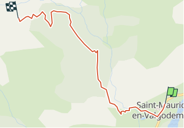
![](/images/other/stat-length.png)
![Tour Wandern Saint-Maurice-en-Valgodemard - cabane de la salette et des 6 cabanes - Photo](https://media.geolcdn.com/t/1900/400/ext.pjpeg?maxdim=2&url=https%3A%2F%2Fstatic1.geolcdn.com%2Fsiteimages%2Fupload%2Ffiles%2F1553511878bg_sport_marche.png)
cabane de la salette et des 6 cabanes
Bernard Rodriguez
Benutzer
![Länge](/images/other/stat-length.png)
![Maximale Höhe](https://static1.geolcdn.com/siteimages/upload/files/1508320355ic_sort_altitude_max_24dp.png)
![Positive Höhendifferenz](https://static1.geolcdn.com/siteimages/upload/files/1508320355ic_sort_den_pos_24dp.png)
![Km-Effort](/images/other/stat-length.png)
![Min. Höhe](https://static1.geolcdn.com/siteimages/upload/files/1508320355ic_sort_altitude_min_24dp.png)
![Negative Höhendifferenz](https://static1.geolcdn.com/siteimages/upload/files/1508320355ic_sort_den_neg_24dp.png)
![Boucle](https://static1.geolcdn.com/siteimages/upload/files/16400158638029165_repeat_loop_refresh_sync_direction_icon.png)
![Wandern](https://static1.geolcdn.com/sitytour/trail-icons/101.png)
3h00
Schwierigkeit : Medium
![Scannen Sie diesen QR-Code, um die Tour in der SityTrail-Anwendung zu öffnen](https://capi.geolives.com/qq0zvz2zws4bq2lad0pu/sitytour/trails/4106193/qr.png?size=200)
Kostenlosegpshiking-Anwendung
Über SityTrail
Tour Wandern von 3,6 km verfügbar auf Provence-Alpes-Côte d'Azur, Hochalpen, Saint-Maurice-en-Valgodemard. Diese Tour wird von Bernard Rodriguez vorgeschlagen.
Beschreibung
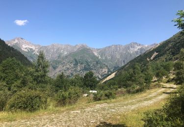
A/R départ st maurice en Depuis le parking de Saint-Maurice en Valgaudemar, revenir sur la route goudronnée vers l’église et bifurquer à droite pour monter dans le village jusqu’au panneau indiquant la direction des 6 cabanes.
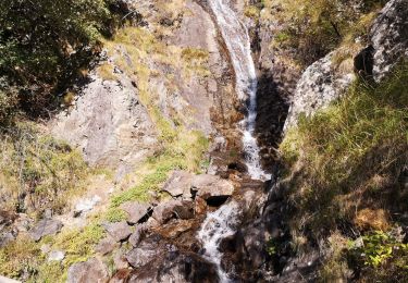
Dès lors, empruntez un sentier balisé avec un point rouge en direction de la cabane de La Salette. Traverser le pont sur le torrent de Saint-Maurice et suivre le sentier.
A la prochaine intersection, suivre le sentier qui monte sur la droite (ne pas prendre le sentier de gauche allant à la cabane de Rochimont). Plus loin, le chemin passe à proximité des ruines en pierres d'un petit hameau d'estive.
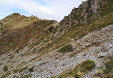
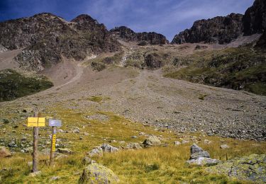
Il amène, peu après, à la cabane pastorale de La Salette située à 1650 m. Après 2h de marche, sa petite fontaine sera la bienvenue. Pour découvrir les « 6 cabanes », poursuivre alors pendant une petite heure la montée à découvert sur un sentier rocailleux et étroit, composé de nombreux lacets, pour se laisser surprendre par cet incroyable hameau à 1980 m.
Après une pause salutaire dans ce superbe cirque, au pied du Grun de Saint-Maurice, imprégné par le poids de l'historique des lieux, le retour pourra se faire par le même chemin.
Ort
Kommentare
Touren in der Umgebung
![Tour Wandern Villar-Loubière - Pic Turbat - Photo](https://media.geolcdn.com/t/375/260/d62b8d76-41e7-46f4-8b33-5d2b5ae47cbd.jpg&format=jpg&maxdim=2)
![Wandern Wandern](https://static1.geolcdn.com/sitytour/trail-icons/101.png)
Wandern
![](/images/other/stat-length.png)
![](https://static1.geolcdn.com/siteimages/upload/files/16400158638029165_repeat_loop_refresh_sync_direction_icon.png)
![Tour Wandern Saint-Maurice-en-Valgodemard - Valgaudemar - l'Ubac Vallon de Prentiq - 14.9km 810m 5h15 - 2018 07 06 - public - Photo](https://media.geolcdn.com/t/375/260/ext.jpg?maxdim=2&url=https%3A%2F%2Fservices.sitytrail.com%2FGeolivesWS%2FDownloadMedia.ashx%3FTrailID%3D999693%26Media%3Dfix__20180706130523.jpg)
![Wandern Wandern](https://static1.geolcdn.com/sitytour/trail-icons/101.png)
Wandern
![](/images/other/stat-length.png)
![](https://static1.geolcdn.com/siteimages/upload/files/16400158638029165_repeat_loop_refresh_sync_direction_icon.png)
![Tour Wandern Villar-Loubière - Col des clochettes - Photo](https://media.geolcdn.com/t/375/260/29cfc5ee-6d83-45be-b231-1befd2c5b10f.jpg&format=jpg&maxdim=2)
![Wandern Wandern](https://static1.geolcdn.com/sitytour/trail-icons/101.png)
Wandern
![](/images/other/stat-length.png)
![](https://static1.geolcdn.com/siteimages/upload/files/16400158638029165_repeat_loop_refresh_sync_direction_icon.png)
![Tour Wandern Villar-Loubière - Valgo2 - J1 : Col des Clochettes - Photo](https://media.geolcdn.com/t/375/260/66a13825-0130-42f3-ad69-09aae21348f4.jpg&format=jpg&maxdim=2)
![Wandern Wandern](https://static1.geolcdn.com/sitytour/trail-icons/101.png)
Wandern
![](/images/other/stat-length.png)
![](https://static1.geolcdn.com/siteimages/upload/files/16400158638029165_repeat_loop_refresh_sync_direction_icon.png)
![Tour Wandern Villar-Loubière - Cime de Turbat. - Photo](https://media.geolcdn.com/t/375/260/fd3d1c78-9f9e-44e7-943a-b9513249c00c.jpg&format=jpg&maxdim=2)
![Wandern Wandern](https://static1.geolcdn.com/sitytour/trail-icons/101.png)
Wandern
![](/images/other/stat-length.png)
![](https://static1.geolcdn.com/siteimages/upload/files/16400158638029165_repeat_loop_refresh_sync_direction_icon.png)
![Tour Wandern Villar-Loubière - Refuge des souffles. - Photo](https://media.geolcdn.com/t/375/260/17d00521-8760-4402-86f9-28679cedc2bc.jpg&format=jpg&maxdim=2)
![Wandern Wandern](https://static1.geolcdn.com/sitytour/trail-icons/101.png)
Wandern
![](/images/other/stat-length.png)
![](https://static1.geolcdn.com/siteimages/upload/files/16400158638029165_repeat_loop_refresh_sync_direction_icon.png)
![Tour Wandern Saint-Firmin - Les pres hauts 6 kms - Photo](https://media.geolcdn.com/t/375/260/acf69bfd-b45f-4a67-8613-3852a16cd78f.jpg&format=jpg&maxdim=2)
![Wandern Wandern](https://static1.geolcdn.com/sitytour/trail-icons/101.png)
Wandern
![](/images/other/stat-length.png)
![](https://static1.geolcdn.com/siteimages/upload/files/16400158638029165_repeat_loop_refresh_sync_direction_icon.png)
![Wandern Wandern](https://static1.geolcdn.com/sitytour/trail-icons/101.png)
Wandern
![](/images/other/stat-length.png)
![](https://static1.geolcdn.com/siteimages/upload/files/16400158638029165_repeat_loop_refresh_sync_direction_icon.png)
![Tour Wandern Villar-Loubière - J2 Valgo - Photo](https://media.geolcdn.com/t/375/260/6400868d-df24-464f-a0d9-916037f23517.jpg&format=jpg&maxdim=2)
![Wandern Wandern](https://static1.geolcdn.com/sitytour/trail-icons/101.png)
Wandern
![](/images/other/stat-length.png)
![](https://static1.geolcdn.com/siteimages/upload/files/16400158638029165_repeat_loop_refresh_sync_direction_icon.png)