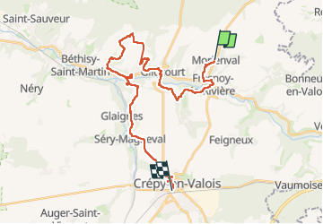
![](/images/other/stat-length.png)
![Tour Zu Fuß Morienval - Morienval- Crepy en Valois par la vallée de l'Automne - Photo](https://media.geolcdn.com/t/1900/400/535655d5-fe74-49b4-b09d-122bf59c29ec.jpg&format=pjpeg&maxdim=2)
Morienval- Crepy en Valois par la vallée de l'Automne
chessyca
Benutzer GUIDE
![Länge](/images/other/stat-length.png)
![Maximale Höhe](https://static1.geolcdn.com/siteimages/upload/files/1508320355ic_sort_altitude_max_24dp.png)
![Positive Höhendifferenz](https://static1.geolcdn.com/siteimages/upload/files/1508320355ic_sort_den_pos_24dp.png)
![Km-Effort](/images/other/stat-length.png)
![Min. Höhe](https://static1.geolcdn.com/siteimages/upload/files/1508320355ic_sort_altitude_min_24dp.png)
![Negative Höhendifferenz](https://static1.geolcdn.com/siteimages/upload/files/1508320355ic_sort_den_neg_24dp.png)
![Boucle](https://static1.geolcdn.com/siteimages/upload/files/16400158638029165_repeat_loop_refresh_sync_direction_icon.png)
![Zu Fuß](https://static1.geolcdn.com/sitytour/trail-icons/100.png)
7h56
Schwierigkeit : Schwierig
![Scannen Sie diesen QR-Code, um die Tour in der SityTrail-Anwendung zu öffnen](https://capi.geolives.com/qq0zvz2zws4bq2lad0pu/sitytour/trails/4101504/qr.png?size=200)
Kostenlosegpshiking-Anwendung
Über SityTrail
Tour Zu Fuß von 28 km verfügbar auf Nordfrankreich, Oise, Morienval. Diese Tour wird von chessyca vorgeschlagen.
Beschreibung
JJL pour le Rif
Ter direction Laon 8h 33 à Gare du Nord
Descendre à Crepy en valois puis bus 657 de 9 h44 . Il y a un petit troquet bien sympa à deux pas de la gare pour attendre le bus.
Descendre à Morienval.
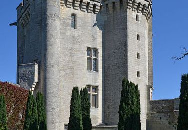
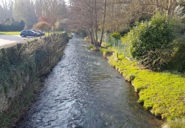
Parcours très intéressant : Outre la très jolie vallée de l'Automne, de charmants villages tels que Bethancourt, le site gallo romain de Champlieu ou ses vestiges d'Abbaye. Pour finir, la visite de Crepy en Valois s'impose
Ort
Kommentare
Touren in der Umgebung
![Tour Wandern Orrouy - en Forêt de Compiègne_41_autour des Petits Monts - Photo](https://media.geolcdn.com/t/375/260/33ce209f-356e-4c94-aaf2-21b4e887d2c9.jpg&format=jpg&maxdim=2)
![Wandern Wandern](https://static1.geolcdn.com/sitytour/trail-icons/101.png)
Wandern
![](/images/other/stat-length.png)
![](https://static1.geolcdn.com/siteimages/upload/files/16400158638029165_repeat_loop_refresh_sync_direction_icon.png)
![Tour Wandern Morienval - en forêt de Compiègne_37_les Tournantes des Petits Monts (sur et sous) - Photo](https://media.geolcdn.com/t/375/260/ext.jpg?maxdim=2&url=https%3A%2F%2Fservices.sitytrail.com%2FGeolivesWS%2FDownloadMedia.ashx%3FTrailID%3D924054%26Media%3D0f1f6a2b-d1e6-4243-9185-6a6591e598b4.JPG)
![Wandern Wandern](https://static1.geolcdn.com/sitytour/trail-icons/101.png)
Wandern
![](/images/other/stat-length.png)
![](https://static1.geolcdn.com/siteimages/upload/files/16400158638029165_repeat_loop_refresh_sync_direction_icon.png)
![Tour Hybrid-Bike Orrouy - Balade vélo entre pierrefond et compiegne - Photo](https://media.geolcdn.com/t/375/260/b93c6913-b0bc-4e73-acd4-b9a591a5fc34.jpg&format=jpg&maxdim=2)
![Hybrid-Bike Hybrid-Bike](https://static1.geolcdn.com/sitytour/trail-icons/203.png)
Hybrid-Bike
![](/images/other/stat-length.png)
![](https://static1.geolcdn.com/siteimages/upload/files/16400158638029165_repeat_loop_refresh_sync_direction_icon.png)
![Tour Wandern Saint-Jean-aux-Bois - en forêt de Compiègne_36_Tournantes sur les Grands Monts et les Grueries - Photo](https://media.geolcdn.com/t/375/260/ext.jpg?maxdim=2&url=https%3A%2F%2Fservices.sitytrail.com%2FGeolivesWS%2FDownloadMedia.ashx%3FTrailID%3D590179%26Media%3Dcdb783f6-c879-4797-9a86-1ea26bf633f9.JPG)
![Wandern Wandern](https://static1.geolcdn.com/sitytour/trail-icons/101.png)
Wandern
![](/images/other/stat-length.png)
![](https://static1.geolcdn.com/siteimages/upload/files/16400158638029165_repeat_loop_refresh_sync_direction_icon.png)
![Tour Wandern Feigneux - Vez en Automne - Feigneux - Photo](https://media.geolcdn.com/t/375/260/ext.jpg?maxdim=2&url=https%3A%2F%2Fservices.sitytrail.com%2FGeolivesWS%2FDownloadMedia.ashx%3FTrailID%3D317010%26Media%3D16150_5.jpg)
![Wandern Wandern](https://static1.geolcdn.com/sitytour/trail-icons/101.png)
Wandern
![](/images/other/stat-length.png)
![](https://static1.geolcdn.com/siteimages/upload/files/16400158638029165_repeat_loop_refresh_sync_direction_icon.png)
![Tour Mountainbike Fresnoy-la-Rivière - Clochers en Vallée de l'Automne (version courte) - Fresnoy-la-Rivière - Photo](https://media.geolcdn.com/t/375/260/ext.jpg?maxdim=2&url=https%3A%2F%2Fservices.sitytrail.com%2FGeolivesWS%2FDownloadMedia.ashx%3FTrailID%3D111167%26Media%3D6606_4.jpg)
![Mountainbike Mountainbike](https://static1.geolcdn.com/sitytour/trail-icons/202.png)
Mountainbike
![](/images/other/stat-length.png)
![](https://static1.geolcdn.com/siteimages/upload/files/16400158638029165_repeat_loop_refresh_sync_direction_icon.png)
![Tour Wandern Fresnoy-la-Rivière - Clochers en Vallée de l'Automne (version courte) - Fresnoy-la-Rivière - Photo](https://media.geolcdn.com/t/375/260/ext.jpg?maxdim=2&url=https%3A%2F%2Fservices.sitytrail.com%2FGeolivesWS%2FDownloadMedia.ashx%3FTrailID%3D111166%26Media%3D6606_4.jpg)
![Wandern Wandern](https://static1.geolcdn.com/sitytour/trail-icons/101.png)
Wandern
![](/images/other/stat-length.png)
![](https://static1.geolcdn.com/siteimages/upload/files/16400158638029165_repeat_loop_refresh_sync_direction_icon.png)
![Tour Zu Fuß Orrouy - Promenade des Chars Romains et Chars de Combat - Photo](https://media.geolcdn.com/t/375/260/b95b32a8-14f5-4d78-af84-afab6a4fc882.jpeg&format=jpg&maxdim=2)
![Zu Fuß Zu Fuß](https://static1.geolcdn.com/sitytour/trail-icons/100.png)
Zu Fuß
![](/images/other/stat-length.png)
![](https://static1.geolcdn.com/siteimages/upload/files/16400158638029165_repeat_loop_refresh_sync_direction_icon.png)
![Tour Wandern Fresnoy-la-Rivière - Fresnoy-la-Rivière - Photo](https://media.geolcdn.com/t/375/260/5da58e15-7bb1-4b85-b1bf-12a84cc1a557.jpg&format=jpg&maxdim=2)
![Wandern Wandern](https://static1.geolcdn.com/sitytour/trail-icons/101.png)
Wandern
![](/images/other/stat-length.png)
![](https://static1.geolcdn.com/siteimages/upload/files/16400158638029165_repeat_loop_refresh_sync_direction_icon.png)