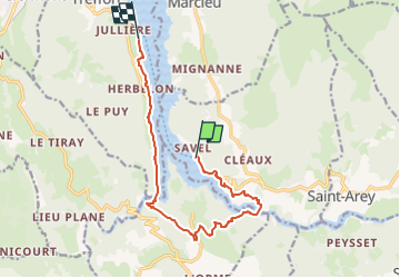
![](/images/other/stat-length.png)
![Tour Wandern Mayres-Savel - Passerelles himalayennes du Monteynard - Photo](https://media.geolcdn.com/t/1900/400/ext.pjpeg?maxdim=2&url=https%3A%2F%2Fstatic1.geolcdn.com%2Fsiteimages%2Fupload%2Ffiles%2F1553511878bg_sport_marche.png)
Passerelles himalayennes du Monteynard
Maryma
Benutzer
![Länge](/images/other/stat-length.png)
![Maximale Höhe](https://static1.geolcdn.com/siteimages/upload/files/1508320355ic_sort_altitude_max_24dp.png)
![Positive Höhendifferenz](https://static1.geolcdn.com/siteimages/upload/files/1508320355ic_sort_den_pos_24dp.png)
![Km-Effort](/images/other/stat-length.png)
![Min. Höhe](https://static1.geolcdn.com/siteimages/upload/files/1508320355ic_sort_altitude_min_24dp.png)
![Negative Höhendifferenz](https://static1.geolcdn.com/siteimages/upload/files/1508320355ic_sort_den_neg_24dp.png)
![Boucle](https://static1.geolcdn.com/siteimages/upload/files/16400158638029165_repeat_loop_refresh_sync_direction_icon.png)
![Wandern](https://static1.geolcdn.com/sitytour/trail-icons/101.png)
4h08
Schwierigkeit : Medium
![Scannen Sie diesen QR-Code, um die Tour in der SityTrail-Anwendung zu öffnen](https://capi.geolives.com/qq0zvz2zws4bq2lad0pu/sitytour/trails/4076497/qr.png?size=200)
Kostenlosegpshiking-Anwendung
Über SityTrail
Tour Wandern von 11,9 km verfügbar auf Auvergne-Rhone-Alpen, Isère, Mayres-Savel. Diese Tour wird von Maryma vorgeschlagen.
Beschreibung
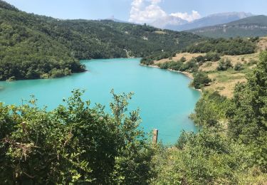
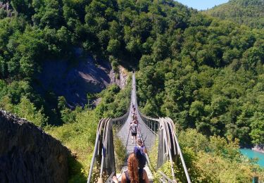
Départ depuis Treffort ou depuis Mayres-Savel.
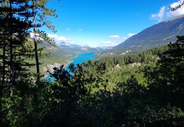
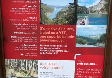
Commencez par une traversée commentée de 30 minutes en bateau afin de rejoindre l'autre rive. Puis débutez la randonnée pour revenir au point de départ en empruntant les deux passerelles. Celle du Drac mesure 220 mètres de long, et celle de l'Ebron mesure 180 mètres. Expérience surprenante à 80 mètres au dessus du lac!
Ort
Kommentare
Touren in der Umgebung
![Tour Wandern Mayres-Savel - Passerelles Du Drac Et de L'Ebron - Photo](https://media.geolcdn.com/t/375/260/f4846bf3-414e-4c51-a6cb-c2da9b823649.jpg&format=jpg&maxdim=2)
![Wandern Wandern](https://static1.geolcdn.com/sitytour/trail-icons/101.png)
Wandern
![](/images/other/stat-length.png)
![](https://static1.geolcdn.com/siteimages/upload/files/16400158638029165_repeat_loop_refresh_sync_direction_icon.png)
![Tour Pferd Roissard - Trieves - Devoluy - Photo](https://media.geolcdn.com/t/375/260/532091fd-ff63-40b6-9790-4b260fef3e51.jpg&format=jpg&maxdim=2)
![Pferd Pferd](https://static1.geolcdn.com/sitytour/trail-icons/300.png)
Pferd
![](/images/other/stat-length.png)
![](https://static1.geolcdn.com/siteimages/upload/files/16400158638029165_repeat_loop_refresh_sync_direction_icon.png)
![Tour Wandern Mayres-Savel - Passerelles Hymalayene Mayres + 250 - Photo](https://media.geolcdn.com/t/375/260/e79ec6b2-c62a-43e0-95ca-91baa034bf5d.jpg&format=jpg&maxdim=2)
![Wandern Wandern](https://static1.geolcdn.com/sitytour/trail-icons/101.png)
Wandern
![](/images/other/stat-length.png)
![](https://static1.geolcdn.com/siteimages/upload/files/16400158638029165_repeat_loop_refresh_sync_direction_icon.png)
![Tour Wandern Treffort - ISERE: MONTEYNARD PASSERELLES HIMALAYENNES - Photo](https://media.geolcdn.com/t/375/260/76721c9b-6b33-4db9-86bf-ba7e9a8d140f.jpg&format=jpg&maxdim=2)
![Wandern Wandern](https://static1.geolcdn.com/sitytour/trail-icons/101.png)
Wandern
![](/images/other/stat-length.png)
![](https://static1.geolcdn.com/siteimages/upload/files/16400158638029165_repeat_loop_refresh_sync_direction_icon.png)
![Tour Wandern Mayres-Savel - Randonnée des passerelles - Photo](https://media.geolcdn.com/t/375/260/f81885ad-9d99-466e-990d-175fbd3a925e.jpg&format=jpg&maxdim=2)
![Wandern Wandern](https://static1.geolcdn.com/sitytour/trail-icons/101.png)
Wandern
![](/images/other/stat-length.png)
![](https://static1.geolcdn.com/siteimages/upload/files/16400158638029165_repeat_loop_refresh_sync_direction_icon.png)
![Tour Wandern Treffort - Valgo2 - J3. : les passerelles de Monteynard - Photo](https://media.geolcdn.com/t/375/260/80ded9ce-faa3-4fe9-b5ad-3607bd08278e.jpg&format=jpg&maxdim=2)
![Wandern Wandern](https://static1.geolcdn.com/sitytour/trail-icons/101.png)
Wandern
![](/images/other/stat-length.png)
![](https://static1.geolcdn.com/siteimages/upload/files/16400158638029165_repeat_loop_refresh_sync_direction_icon.png)
![Tour Wandern Treffort - Passerelle Drac - Photo](https://media.geolcdn.com/t/375/260/feb433be-0155-46e7-819a-3b1bb0447bc5.jpg&format=jpg&maxdim=2)
![Wandern Wandern](https://static1.geolcdn.com/sitytour/trail-icons/101.png)
Wandern
![](/images/other/stat-length.png)
![](https://static1.geolcdn.com/siteimages/upload/files/16400158638029165_repeat_loop_refresh_sync_direction_icon.png)
![Tour Wandern Treffort - Les deux passerelles Drac et Ebron - Photo](https://media.geolcdn.com/t/375/260/3778f66d-36c2-41c5-9e06-64b09fbd2374.jpg&format=jpg&maxdim=2)
![Wandern Wandern](https://static1.geolcdn.com/sitytour/trail-icons/101.png)
Wandern
![](/images/other/stat-length.png)
![](https://static1.geolcdn.com/siteimages/upload/files/16400158638029165_repeat_loop_refresh_sync_direction_icon.png)
![Tour Wandern Lavars - Serre de la Fayolle - Photo](https://media.geolcdn.com/t/375/260/95bdaed1-9210-48db-8488-a02aafbf5b89.jpg&format=jpg&maxdim=2)
![Wandern Wandern](https://static1.geolcdn.com/sitytour/trail-icons/101.png)
Wandern
![](/images/other/stat-length.png)
![](https://static1.geolcdn.com/siteimages/upload/files/16400158638029165_repeat_loop_refresh_sync_direction_icon.png)