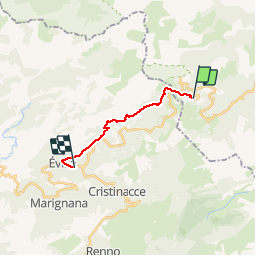
![](/images/other/stat-length.png)
![Tour Wandern Albertacce - Castellu di Vergio - Hôtel Scopa Rossa - Photo](https://media.geolcdn.com/t/1900/400/ext.pjpeg?maxdim=2&url=https%3A%2F%2Fstatic1.geolcdn.com%2Fsiteimages%2Fupload%2Ffiles%2F1553511878bg_sport_marche.png)
Castellu di Vergio - Hôtel Scopa Rossa
CorsicaNatura
Benutzer
![Länge](/images/other/stat-length.png)
![Maximale Höhe](https://static1.geolcdn.com/siteimages/upload/files/1508320355ic_sort_altitude_max_24dp.png)
![Positive Höhendifferenz](https://static1.geolcdn.com/siteimages/upload/files/1508320355ic_sort_den_pos_24dp.png)
![Km-Effort](/images/other/stat-length.png)
![Min. Höhe](https://static1.geolcdn.com/siteimages/upload/files/1508320355ic_sort_altitude_min_24dp.png)
![Negative Höhendifferenz](https://static1.geolcdn.com/siteimages/upload/files/1508320355ic_sort_den_neg_24dp.png)
![Boucle](https://static1.geolcdn.com/siteimages/upload/files/16400158638029165_repeat_loop_refresh_sync_direction_icon.png)
![Wandern](https://static1.geolcdn.com/sitytour/trail-icons/101.png)
4h30
Schwierigkeit : Medium
![Scannen Sie diesen QR-Code, um die Tour in der SityTrail-Anwendung zu öffnen](https://capi.geolives.com/qq0zvz2zws4bq2lad0pu/sitytour/trails/407566/qr.png?size=200)
Kostenlosegpshiking-Anwendung
Über SityTrail
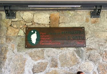
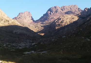
Tour Wandern von 11,8 km verfügbar auf Korsika, Haute-Corse, Albertacce. Diese Tour wird von CorsicaNatura vorgeschlagen.
Beschreibung
• Remonter la route D84 Jusqu’au Col de Vergio (environ 3,5 Km).
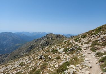
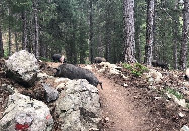
• Traverser la route D 84, au col le sentier se situe au NO du parking ou au NO de la Statue du Christ Roi toujours direction EVISA. Vous cheminez dans la forêt d’Aïtone au cœur de magnifique pin Laricio.
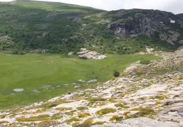
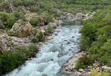
• Vous croisez après environ 1/2 heure de descente une piste forestière, suivez-la par la droite. 1/2 heure plus tard nouveau croisement avec une piste, tournez encore à droite, vous arrivez au pont de Casterica point coté 1186 m. 50 m après le pont le sentier part sur votre gauche. AVous suivez le sentier jusqu’aux piscines naturelles d’aitone Alt.900 mètres.
• Sans traverser la rivière, le chemin longe la rivière sur 400 mètres environ. Un petite ascension vous est proposé pour atteindre le point côté (Alt.1109 mètres) un point de vue spectaculaire sur la vallée. La redescente vers la rivière est raide et parfois techniques sur les cailloux.
• Vous atteignez la rivière d’Aïtone, ( après la passerelle suspendue alti 950m) Voir ancien moulin, possibilité de descendre jusqu’à la Cascade de la Valla Scarpa suivre le sentier riche droite pendant 10 minutes aller retour par le même itinéraire.
• Vous empruntez un chemin de terre, à droite, sur environ 1 Km jusqu’à la route D84. Après 150 mètres de route, vous retrouverez le sentier de découverte, à droite, qui vous amènera à Evisa et vous éclairera sur nos us et coutumes.
• L’hôtel Scopa Rossa se trouve tout en haut du village en remontant la D84
• Une agréable soirée dans un cadre superbe.
Ort
Kommentare
Touren in der Umgebung
![Tour Wandern Albertacce - Bivouac dans le GR 20 via lac Nino - Photo](https://media.geolcdn.com/t/375/260/3ced1be1-6fdd-4396-ba3a-886f89c7dbe2.jpg&format=jpg&maxdim=2)
![Wandern Wandern](https://static1.geolcdn.com/sitytour/trail-icons/101.png)
Wandern
![](/images/other/stat-length.png)
![](https://static1.geolcdn.com/siteimages/upload/files/16400158638029165_repeat_loop_refresh_sync_direction_icon.png)
![Tour Wandern Albertacce - lac de nino(niellu) - Photo](https://media.geolcdn.com/t/375/260/128a0677-0385-456a-9f32-a5bc6e87f160.jpg&format=jpg&maxdim=2)
![Wandern Wandern](https://static1.geolcdn.com/sitytour/trail-icons/101.png)
Wandern
![](/images/other/stat-length.png)
![](https://static1.geolcdn.com/siteimages/upload/files/16400158638029165_repeat_loop_refresh_sync_direction_icon.png)
![Tour Wandern Albertacce - 01/06/2013 9:25lac Nino - Photo](https://media.geolcdn.com/t/375/260/0ea27a89-6f1f-410c-ba94-994c359a65c4.jpg&format=jpg&maxdim=2)
![Wandern Wandern](https://static1.geolcdn.com/sitytour/trail-icons/101.png)
Wandern
![](/images/other/stat-length.png)
![](https://static1.geolcdn.com/siteimages/upload/files/16400158638029165_repeat_loop_refresh_sync_direction_icon.png)
![Tour Andere Aktivitäten Albertacce - lac de nino - Photo](https://media.geolcdn.com/t/375/260/ext.jpg?maxdim=2&url=https%3A%2F%2Fservices.sitytrail.com%2FGeolivesWS%2FDownloadMedia.ashx%3FTrailID%3D990784%26Media%3D20180621160733.jpg)
![Andere Aktivitäten Andere Aktivitäten](https://static1.geolcdn.com/sitytour/trail-icons/900.png)
Andere Aktivitäten
![](/images/other/stat-length.png)
![](https://static1.geolcdn.com/siteimages/upload/files/16400158638029165_repeat_loop_refresh_sync_direction_icon.png)
![Tour Wandern Albertacce - Guy Goujon - Photo](https://media.geolcdn.com/t/375/260/ext.jpg?maxdim=2&url=https%3A%2F%2Fstatic1.geolcdn.com%2Fsiteimages%2Fupload%2Ffiles%2F1553511878bg_sport_marche.png)
![Wandern Wandern](https://static1.geolcdn.com/sitytour/trail-icons/101.png)
Wandern
![](/images/other/stat-length.png)
![](https://static1.geolcdn.com/siteimages/upload/files/16400158638029165_repeat_loop_refresh_sync_direction_icon.png)
![Tour Wandern Albertacce - Castel du Vergio refuge de Mangani - Photo](https://media.geolcdn.com/t/375/260/4054b4bb-471f-4d5e-ba74-4ab3c42b263a.jpg&format=jpg&maxdim=2)
![Wandern Wandern](https://static1.geolcdn.com/sitytour/trail-icons/101.png)
Wandern
![](/images/other/stat-length.png)
![](https://static1.geolcdn.com/siteimages/upload/files/16400158638029165_repeat_loop_refresh_sync_direction_icon.png)
![Tour Wandern Évisa - Corse 2023: Refuge de Puscaghia - Tuvarelli - Photo](https://media.geolcdn.com/t/375/260/d0626a08-0dec-4be5-8024-799debc7c80a.jpeg&format=jpg&maxdim=2)
![Wandern Wandern](https://static1.geolcdn.com/sitytour/trail-icons/101.png)
Wandern
![](/images/other/stat-length.png)
![](https://static1.geolcdn.com/siteimages/upload/files/16400158638029165_repeat_loop_refresh_sync_direction_icon.png)
![Tour Wandern Albertacce - Lac nino - Photo](https://media.geolcdn.com/t/375/260/e5b3bee9-4173-43f5-9625-4fa056135ff5.jpg&format=jpg&maxdim=2)
![Wandern Wandern](https://static1.geolcdn.com/sitytour/trail-icons/101.png)
Wandern
![](/images/other/stat-length.png)
![](https://static1.geolcdn.com/siteimages/upload/files/16400158638029165_repeat_loop_refresh_sync_direction_icon.png)
![Tour Wandern Albertacce - Trou du diable du capu tafunatu - Photo](https://media.geolcdn.com/t/375/260/3c70327f-8683-4ca1-930f-102d3079b734.jpg&format=jpg&maxdim=2)
![Wandern Wandern](https://static1.geolcdn.com/sitytour/trail-icons/101.png)
Wandern
![](/images/other/stat-length.png)
![](https://static1.geolcdn.com/siteimages/upload/files/16400158638029165_repeat_loop_refresh_sync_direction_icon.png)