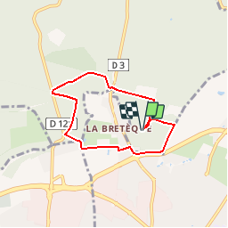
![](/images/other/stat-length.png)
![Tour Nordic Walking Houppeville - Forêt Verte MN-10 - Photo](https://media.geolcdn.com/t/1900/400/ext.pjpeg?maxdim=2&url=https%3A%2F%2Fstatic1.geolcdn.com%2Fsiteimages%2Fupload%2Ffiles%2F1545311037marcheuse_200dpi.jpg)
Forêt Verte MN-10
philippe76
Benutzer
![Länge](/images/other/stat-length.png)
![Maximale Höhe](https://static1.geolcdn.com/siteimages/upload/files/1508320355ic_sort_altitude_max_24dp.png)
![Positive Höhendifferenz](https://static1.geolcdn.com/siteimages/upload/files/1508320355ic_sort_den_pos_24dp.png)
![Km-Effort](/images/other/stat-length.png)
![Min. Höhe](https://static1.geolcdn.com/siteimages/upload/files/1508320355ic_sort_altitude_min_24dp.png)
![Negative Höhendifferenz](https://static1.geolcdn.com/siteimages/upload/files/1508320355ic_sort_den_neg_24dp.png)
![Boucle](https://static1.geolcdn.com/siteimages/upload/files/16400158638029165_repeat_loop_refresh_sync_direction_icon.png)
![Nordic Walking](https://static1.geolcdn.com/sitytour/trail-icons/102.png)
1h00
Schwierigkeit : Einfach
![Scannen Sie diesen QR-Code, um die Tour in der SityTrail-Anwendung zu öffnen](https://capi.geolives.com/qq0zvz2zws4bq2lad0pu/sitytour/trails/407425/qr.png?size=200)
Kostenlosegpshiking-Anwendung
Über SityTrail
Tour Nordic Walking von 5,5 km verfügbar auf Normandie, Seine-Maritime, Houppeville. Diese Tour wird von philippe76 vorgeschlagen.
Beschreibung
Départ Parking. TD et AG vers la Bretèque. TD la D3, et AD au Park de La Bretèque. TD et AG chemin, AG Rte du Val Allard Pt 144. Monter vers Pt 161, AD Rte Forestière du Bel Event. Au park, AG chemin en forêt, jusqu'à la plaine et passer près du centre équestre.AD, AG puis AD sur la D3; AG au park. AD vers le chemin de la Bicyclette, puis AG jusqu'au chalet. TD vers la Bretèque. Traverser la D3, et AD au parking de La Bretèque. TD jusqu'au point 155. Prendre AG la route du Val Allard jusqu'au point 144. Remonter vers le point 161 vers la rte Forestière du Bel Event. Au park, AG le chemin en forêt, jusqu'à la plaine. jusqu'au PT 164. AD, AG puis AD sur la D3; enfin AG chemin de la Bicyclette. AG, AG vers le parking.
Ort
Kommentare
Touren in der Umgebung
![Tour Wandern Mont-Saint-Aignan - Mont-saint-aignan - Chasse-Marée - - Photo](https://media.geolcdn.com/t/375/260/9cf681a4-2bd4-44f5-95c9-4e27e69bf20e.jpg&format=jpg&maxdim=2)
![Wandern Wandern](https://static1.geolcdn.com/sitytour/trail-icons/101.png)
Wandern
![](/images/other/stat-length.png)
![](https://static1.geolcdn.com/siteimages/upload/files/16400158638029165_repeat_loop_refresh_sync_direction_icon.png)
![Wandern Wandern](https://static1.geolcdn.com/sitytour/trail-icons/101.png)
Wandern
![](/images/other/stat-length.png)
![](https://static1.geolcdn.com/siteimages/upload/files/16400158638029165_repeat_loop_refresh_sync_direction_icon.png)
![Tour Wandern Rouen - Découverte du Vieux Rouen - Photo](https://media.geolcdn.com/t/375/260/07f58fb9-e0a2-467d-b259-7f5f14d6fd45.jpg&format=jpg&maxdim=2)
![Wandern Wandern](https://static1.geolcdn.com/sitytour/trail-icons/101.png)
Wandern
![](/images/other/stat-length.png)
![](https://static1.geolcdn.com/siteimages/upload/files/16400158638029165_repeat_loop_refresh_sync_direction_icon.png)
![Wandern Wandern](https://static1.geolcdn.com/sitytour/trail-icons/101.png)
Wandern
![](/images/other/stat-length.png)
![](https://static1.geolcdn.com/siteimages/upload/files/16400158638029165_repeat_loop_refresh_sync_direction_icon.png)
![Tour Nordic Walking Bois-Guillaume - MN - Bois-Guillaume - Bretèque - Photo](https://media.geolcdn.com/t/375/260/ext.jpg?maxdim=2&url=https%3A%2F%2Fstatic1.geolcdn.com%2Fsiteimages%2Fupload%2Ffiles%2F1545311037marcheuse_200dpi.jpg)
![Nordic Walking Nordic Walking](https://static1.geolcdn.com/sitytour/trail-icons/102.png)
Nordic Walking
![](/images/other/stat-length.png)
![](https://static1.geolcdn.com/siteimages/upload/files/16400158638029165_repeat_loop_refresh_sync_direction_icon.png)
![Wandern Wandern](https://static1.geolcdn.com/sitytour/trail-icons/101.png)
Wandern
![](/images/other/stat-length.png)
![](https://static1.geolcdn.com/siteimages/upload/files/16400158638029165_repeat_loop_refresh_sync_direction_icon.png)
![Wandern Wandern](https://static1.geolcdn.com/sitytour/trail-icons/101.png)
Wandern
![](/images/other/stat-length.png)
![](https://static1.geolcdn.com/siteimages/upload/files/16400158638029165_repeat_loop_refresh_sync_direction_icon.png)
![Tour Wandern Déville-lès-Rouen - 20230504-Déville les Rouen - Photo](https://media.geolcdn.com/t/375/260/eed96392-23a7-4859-84f4-8afb1f8dae77.jpg&format=jpg&maxdim=2)
![Wandern Wandern](https://static1.geolcdn.com/sitytour/trail-icons/101.png)
Wandern
![](/images/other/stat-length.png)
![](https://static1.geolcdn.com/siteimages/upload/files/16400158638029165_repeat_loop_refresh_sync_direction_icon.png)
![Wandern Wandern](https://static1.geolcdn.com/sitytour/trail-icons/101.png)
Wandern
![](/images/other/stat-length.png)
![](https://static1.geolcdn.com/siteimages/upload/files/16400158638029165_repeat_loop_refresh_sync_direction_icon.png)