![](/images/other/stat-length.png)
![Tour Zu Fuß Aubergenville - sitytrail-grp-la-seine-impressionniste-parcours-complet - Photo](https://media.geolcdn.com/t/1900/400/ext.pjpeg?maxdim=2&url=https%3A%2F%2Fstatic1.geolcdn.com%2Fsiteimages%2Fupload%2Ffiles%2F1545311037marcheuse_200dpi.jpg)
sitytrail-grp-la-seine-impressionniste-parcours-complet
chessyca
Benutzer GUIDE
![Länge](/images/other/stat-length.png)
Länge
37 km
![Maximale Höhe](https://static1.geolcdn.com/siteimages/upload/files/1508320355ic_sort_altitude_max_24dp.png)
Maximale Höhe
150 m
![Positive Höhendifferenz](https://static1.geolcdn.com/siteimages/upload/files/1508320355ic_sort_den_pos_24dp.png)
Positive Höhendifferenz
446 m
![Km-Effort](/images/other/stat-length.png)
Km-Effort
43 km
![Min. Höhe](https://static1.geolcdn.com/siteimages/upload/files/1508320355ic_sort_altitude_min_24dp.png)
Min. Höhe
14 m
![Negative Höhendifferenz](https://static1.geolcdn.com/siteimages/upload/files/1508320355ic_sort_den_neg_24dp.png)
Negative Höhendifferenz
454 m
![Boucle](https://static1.geolcdn.com/siteimages/upload/files/16400158638029165_repeat_loop_refresh_sync_direction_icon.png)
Boucle
Nein
Erstellungsdatum :
2024-05-25 17:43:33.058
Letzte Änderung :
2024-05-25 17:54:42.999
![Zu Fuß](https://static1.geolcdn.com/sitytour/trail-icons/100.png)
9h42
Schwierigkeit : Sehr schwierig
![Scannen Sie diesen QR-Code, um die Tour in der SityTrail-Anwendung zu öffnen](https://capi.geolives.com/qq0zvz2zws4bq2lad0pu/sitytour/trails/4067777/qr.png?size=200)
Kostenlosegpshiking-Anwendung
Über SityTrail
Tour Zu Fuß von 37 km verfügbar auf Île-de-France, Yvelines, Aubergenville. Diese Tour wird von chessyca vorgeschlagen.
Beschreibung
Etape 1 Chatou Sartrouville
Etape 2 Sartrouville Conflans Ste Honorine
Etape 3 Conflans Ste Honorine Triels
Etape 4 Triels Aubergenville
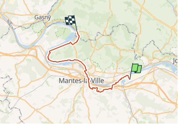
Etape 5 Aubergenville Mantes
Etape 6 Mantes Vétheuil
Etape 7 Vétheuil Bonnières
Etape 8 Bonnières Vernon
Ort
Land:
France
Region :
Île-de-France
Abteilung/Provinz :
Yvelines
Kommune :
Aubergenville
Standort:
Unknown
Gehen Sie:(Dec)
Gehen Sie:(UTM)
415508 ; 5425457 (31U) N.
Kommentare
Touren in der Umgebung
![Tour Wandern Épône - la vallée de la Mauldre - Photo](https://media.geolcdn.com/t/375/260/0a4d8157-4a98-411e-8a67-9b000ec43e58.jpg&format=jpg&maxdim=2)
![Wandern Wandern](https://static1.geolcdn.com/sitytour/trail-icons/101.png)
la vallée de la Mauldre
Wandern
Schwierig
Épône,
Île-de-France,
Yvelines,
France
![](/images/other/stat-length.png)
28 km | 35 km-effort
5h 52min
![](https://static1.geolcdn.com/siteimages/upload/files/16400158638029165_repeat_loop_refresh_sync_direction_icon.png)
Nein
![Tour Andere Aktivitäten Gargenville - parcourt FIFI - Photo](https://media.geolcdn.com/t/375/260/ext.jpg?maxdim=2&url=https%3A%2F%2Fstatic1.geolcdn.com%2Fsiteimages%2Fupload%2Ffiles%2F1545311037marcheuse_200dpi.jpg)
![Andere Aktivitäten Andere Aktivitäten](https://static1.geolcdn.com/sitytour/trail-icons/900.png)
parcourt FIFI
Andere Aktivitäten
Sehr leicht
(1)
Gargenville,
Île-de-France,
Yvelines,
France
![](/images/other/stat-length.png)
42 km | 46 km-effort
2h 49min
![](https://static1.geolcdn.com/siteimages/upload/files/16400158638029165_repeat_loop_refresh_sync_direction_icon.png)
Nein
![Tour Wandern La Falaise - Aulney sur Mauldre-La Falaise - Photo](https://media.geolcdn.com/t/375/260/ext.jpg?maxdim=2&url=https%3A%2F%2Fstatic1.geolcdn.com%2Fsiteimages%2Fupload%2Ffiles%2F1553511878bg_sport_marche.png)
![Wandern Wandern](https://static1.geolcdn.com/sitytour/trail-icons/101.png)
Aulney sur Mauldre-La Falaise
Wandern
Medium
(1)
La Falaise,
Île-de-France,
Yvelines,
France
![](/images/other/stat-length.png)
12,4 km | 15,9 km-effort
Unbekannt
![](https://static1.geolcdn.com/siteimages/upload/files/16400158638029165_repeat_loop_refresh_sync_direction_icon.png)
Ja
![Tour Wandern Épône - EPONES > MAREIL 15 KM - Photo](https://media.geolcdn.com/t/375/260/ext.jpg?maxdim=2&url=https%3A%2F%2Fstatic1.geolcdn.com%2Fsiteimages%2Fupload%2Ffiles%2F1553511878bg_sport_marche.png)
![Wandern Wandern](https://static1.geolcdn.com/sitytour/trail-icons/101.png)
EPONES > MAREIL 15 KM
Wandern
Sehr leicht
(1)
Épône,
Île-de-France,
Yvelines,
France
![](/images/other/stat-length.png)
14,7 km | 18,6 km-effort
3h 55min
![](https://static1.geolcdn.com/siteimages/upload/files/16400158638029165_repeat_loop_refresh_sync_direction_icon.png)
Nein
![Tour Wandern Aubergenville - petite balade autour du Gibouin - Photo](https://media.geolcdn.com/t/375/260/ext.jpg?maxdim=2&url=https%3A%2F%2Fservices.sitytrail.com%2FGeolivesWS%2FDownloadMedia.ashx%3FTrailID%3D255767%26Media%3D20140119115431.jpg)
![Wandern Wandern](https://static1.geolcdn.com/sitytour/trail-icons/101.png)
petite balade autour du Gibouin
Wandern
Sehr leicht
Aubergenville,
Île-de-France,
Yvelines,
France
![](/images/other/stat-length.png)
7,7 km | 8,2 km-effort
1h 45min
![](https://static1.geolcdn.com/siteimages/upload/files/16400158638029165_repeat_loop_refresh_sync_direction_icon.png)
Ja
![Tour Wandern Nézel - Nezel - Aulnay sur Mauldre - Photo](https://media.geolcdn.com/t/375/260/ext.jpg?maxdim=2&url=https%3A%2F%2Fstatic1.geolcdn.com%2Fsiteimages%2Fupload%2Ffiles%2F1553511878bg_sport_marche.png)
![Wandern Wandern](https://static1.geolcdn.com/sitytour/trail-icons/101.png)
Nezel - Aulnay sur Mauldre
Wandern
Einfach
(1)
Nézel,
Île-de-France,
Yvelines,
France
![](/images/other/stat-length.png)
9,2 km | 11 km-effort
2h 23min
![](https://static1.geolcdn.com/siteimages/upload/files/16400158638029165_repeat_loop_refresh_sync_direction_icon.png)
Ja
![Tour Wandern Aubergenville - Vaux les Huguenots - Photo](https://media.geolcdn.com/t/375/260/ext.jpg?maxdim=2&url=https%3A%2F%2Fstatic1.geolcdn.com%2Fsiteimages%2Fupload%2Ffiles%2F1553511878bg_sport_marche.png)
![Wandern Wandern](https://static1.geolcdn.com/sitytour/trail-icons/101.png)
Vaux les Huguenots
Wandern
Einfach
(2)
Aubergenville,
Île-de-France,
Yvelines,
France
![](/images/other/stat-length.png)
7,7 km | 10,1 km-effort
2h 10min
![](https://static1.geolcdn.com/siteimages/upload/files/16400158638029165_repeat_loop_refresh_sync_direction_icon.png)
Ja
![Tour Laufen Les Mureaux - Trail 15K G.O-parc de la sautour - Photo](https://media.geolcdn.com/t/375/260/ext.jpg?maxdim=2&url=https%3A%2F%2Fstatic1.geolcdn.com%2Fsiteimages%2Fupload%2Ffiles%2F1524743154running.jpg)
![Laufen Laufen](https://static1.geolcdn.com/sitytour/trail-icons/103.png)
Trail 15K G.O-parc de la sautour
Laufen
Medium
(1)
Les Mureaux,
Île-de-France,
Yvelines,
France
![](/images/other/stat-length.png)
15,3 km | 18,7 km-effort
Unbekannt
![](https://static1.geolcdn.com/siteimages/upload/files/16400158638029165_repeat_loop_refresh_sync_direction_icon.png)
Nein
![Tour Zu Fuß Aubergenville - La Seine impressioniste Etape 5 + Boucle Rosny - Mantes - Photo](https://media.geolcdn.com/t/375/260/ext.jpg?maxdim=2&url=https%3A%2F%2Fstatic1.geolcdn.com%2Fsiteimages%2Fupload%2Ffiles%2F1545311037marcheuse_200dpi.jpg)
![Zu Fuß Zu Fuß](https://static1.geolcdn.com/sitytour/trail-icons/100.png)
La Seine impressioniste Etape 5 + Boucle Rosny - Mantes
Zu Fuß
Sehr schwierig
Aubergenville,
Île-de-France,
Yvelines,
France
![](/images/other/stat-length.png)
39 km | 44 km-effort
10h 2min
![](https://static1.geolcdn.com/siteimages/upload/files/16400158638029165_repeat_loop_refresh_sync_direction_icon.png)
Nein