![](/images/other/stat-length.png)
![Tour Elektrofahrrad Peyreleau - Boucle Mont Aigoual en partant de Peyreleau - Photo](https://media.geolcdn.com/t/1900/400/ext.pjpeg?maxdim=2&url=https%3A%2F%2Fstatic1.geolcdn.com%2Fsiteimages%2Fupload%2Ffiles%2F1524743154velo.jpg)
Boucle Mont Aigoual en partant de Peyreleau
franquen
Benutzer
![Länge](/images/other/stat-length.png)
Länge
95 km
![Maximale Höhe](https://static1.geolcdn.com/siteimages/upload/files/1508320355ic_sort_altitude_max_24dp.png)
Maximale Höhe
1561 m
![Positive Höhendifferenz](https://static1.geolcdn.com/siteimages/upload/files/1508320355ic_sort_den_pos_24dp.png)
Positive Höhendifferenz
1995 m
![Km-Effort](/images/other/stat-length.png)
Km-Effort
121 km
![Min. Höhe](https://static1.geolcdn.com/siteimages/upload/files/1508320355ic_sort_altitude_min_24dp.png)
Min. Höhe
395 m
![Negative Höhendifferenz](https://static1.geolcdn.com/siteimages/upload/files/1508320355ic_sort_den_neg_24dp.png)
Negative Höhendifferenz
1995 m
![Boucle](https://static1.geolcdn.com/siteimages/upload/files/16400158638029165_repeat_loop_refresh_sync_direction_icon.png)
Boucle
Ja
Erstellungsdatum :
2024-05-22 08:09:24.433
Letzte Änderung :
2024-05-22 16:06:39.674
![Elektrofahrrad](https://static1.geolcdn.com/sitytour/trail-icons/205.png)
5h46
Schwierigkeit : Sehr leicht
![Scannen Sie diesen QR-Code, um die Tour in der SityTrail-Anwendung zu öffnen](https://capi.geolives.com/qq0zvz2zws4bq2lad0pu/sitytour/trails/4064100/qr.png?size=200)
Kostenlosegpshiking-Anwendung
Über SityTrail
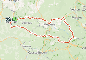
Tour Elektrofahrrad von 95 km verfügbar auf Okzitanien, Aveyron, Peyreleau. Diese Tour wird von franquen vorgeschlagen.
Beschreibung
Très belle rando en passant dans les gorges de la Jonte , puis au sommet du Mt Aigoual et retour sur le plateau. Rando un peu longue mais sans difficulté, attention aux batteries !
Ort
Land:
France
Region :
Okzitanien
Abteilung/Provinz :
Aveyron
Kommune :
Peyreleau
Standort:
Unknown
Gehen Sie:(Dec)
Gehen Sie:(UTM)
516914 ; 4891462 (31T) N.
Kommentare
Touren in der Umgebung
![Tour Wandern Le Rozier - 12 vase de Sèvres Chine ch. brunet - Photo](https://media.geolcdn.com/t/375/260/42bd83b0-7fd2-4ea6-86ca-ddc89ff015aa.jpg&format=jpg&maxdim=2)
![Wandern Wandern](https://static1.geolcdn.com/sitytour/trail-icons/101.png)
12 vase de Sèvres Chine ch. brunet
Wandern
Medium
(1)
Le Rozier,
Okzitanien,
Lozère,
France
![](/images/other/stat-length.png)
10,1 km | 18,8 km-effort
5h 40min
![](https://static1.geolcdn.com/siteimages/upload/files/16400158638029165_repeat_loop_refresh_sync_direction_icon.png)
Ja
![Tour Wandern Mostuéjouls - Cirque de Saint Marcellin - Mostuéjouls - Liaucous - Photo](https://media.geolcdn.com/t/375/260/ext.jpg?maxdim=2&url=https%3A%2F%2Fservices.sitytrail.com%2FGeolivesWS%2FDownloadMedia.ashx%3FTrailID%3D173134%26Media%3D14690_6.jpg)
![Wandern Wandern](https://static1.geolcdn.com/sitytour/trail-icons/101.png)
Cirque de Saint Marcellin - Mostuéjouls - Liaucous
Wandern
Medium
(1)
Mostuéjouls,
Okzitanien,
Aveyron,
France
![](/images/other/stat-length.png)
15,4 km | 24 km-effort
5h 0min
![](https://static1.geolcdn.com/siteimages/upload/files/16400158638029165_repeat_loop_refresh_sync_direction_icon.png)
Ja
![Tour Wandern Le Rozier - Causse et gorges au pays des vautours - Photo](https://media.geolcdn.com/t/375/260/cab4842f-73f8-42f5-b236-9c9a4da22964.jpg&format=jpg&maxdim=2)
![Wandern Wandern](https://static1.geolcdn.com/sitytour/trail-icons/101.png)
Causse et gorges au pays des vautours
Wandern
Schwierig
Le Rozier,
Okzitanien,
Lozère,
France
![](/images/other/stat-length.png)
27 km | 40 km-effort
7h 48min
![](https://static1.geolcdn.com/siteimages/upload/files/16400158638029165_repeat_loop_refresh_sync_direction_icon.png)
Nein
![Tour Wandern Saint-Pierre-des-Tripiers - Cassagnes crête vallée Jonte et Tarn 12,2 km - Photo](https://media.geolcdn.com/t/375/260/9473c7ff-c94b-41a9-84a9-d12f53c1c0cb.jpg&format=jpg&maxdim=2)
![Wandern Wandern](https://static1.geolcdn.com/sitytour/trail-icons/101.png)
Cassagnes crête vallée Jonte et Tarn 12,2 km
Wandern
Medium
Saint-Pierre-des-Tripiers,
Okzitanien,
Lozère,
France
![](/images/other/stat-length.png)
12,6 km | 20 km-effort
5h 38min
![](https://static1.geolcdn.com/siteimages/upload/files/16400158638029165_repeat_loop_refresh_sync_direction_icon.png)
Nein
![Tour Wandern Saint-Pierre-des-Tripiers - Grands Causses - Cassagnes - Corniches du Causse Méjean - 2016 09 08 - Photo](https://media.geolcdn.com/t/375/260/ext.jpg?maxdim=2&url=https%3A%2F%2Fservices.sitytrail.com%2FGeolivesWS%2FDownloadMedia.ashx%3FTrailID%3D629401%26Media%3Dfix__20160908104835.jpg)
![Wandern Wandern](https://static1.geolcdn.com/sitytour/trail-icons/101.png)
Grands Causses - Cassagnes - Corniches du Causse Méjean - 2016 09 08
Wandern
Medium
Saint-Pierre-des-Tripiers,
Okzitanien,
Lozère,
France
![](/images/other/stat-length.png)
8,4 km | 14,2 km-effort
3h 10min
![](https://static1.geolcdn.com/siteimages/upload/files/16400158638029165_repeat_loop_refresh_sync_direction_icon.png)
Ja
![Tour Wandern Peyreleau - Grands Causses - Peyreleau - Corniches du Causse Noir- 2016 09 06 - Photo](https://media.geolcdn.com/t/375/260/ext.jpg?maxdim=2&url=https%3A%2F%2Fservices.sitytrail.com%2FGeolivesWS%2FDownloadMedia.ashx%3FTrailID%3D629392%26Media%3Dfix__20160906104401.jpg)
![Wandern Wandern](https://static1.geolcdn.com/sitytour/trail-icons/101.png)
Grands Causses - Peyreleau - Corniches du Causse Noir- 2016 09 06
Wandern
Schwierig
Peyreleau,
Okzitanien,
Aveyron,
France
![](/images/other/stat-length.png)
12,5 km | 21 km-effort
6h 40min
![](https://static1.geolcdn.com/siteimages/upload/files/16400158638029165_repeat_loop_refresh_sync_direction_icon.png)
Ja
![Tour Wandern Saint-Pierre-des-Tripiers - Grands Causses - La Viale - Corniches de la Jonte et du Tarn - 2016 07 03 - 880m 20,7km - Photo](https://media.geolcdn.com/t/375/260/ext.jpg?maxdim=2&url=https%3A%2F%2Fservices.sitytrail.com%2FGeolivesWS%2FDownloadMedia.ashx%3FTrailID%3D595303%26Media%3Dfix__20160703150624.jpg)
![Wandern Wandern](https://static1.geolcdn.com/sitytour/trail-icons/101.png)
Grands Causses - La Viale - Corniches de la Jonte et du Tarn - 2016 07 03 - 8...
Wandern
Medium
Saint-Pierre-des-Tripiers,
Okzitanien,
Lozère,
France
![](/images/other/stat-length.png)
21 km | 30 km-effort
6h 40min
![](https://static1.geolcdn.com/siteimages/upload/files/16400158638029165_repeat_loop_refresh_sync_direction_icon.png)
Ja
![Tour Wandern Mostuéjouls - Grands Causses - Liaucous - St-Marcellin - 2016 07 04 - 680m 14,3km - Photo](https://media.geolcdn.com/t/375/260/ext.jpg?maxdim=2&url=https%3A%2F%2Fservices.sitytrail.com%2FGeolivesWS%2FDownloadMedia.ashx%3FTrailID%3D595296%26Media%3Dfix__20160704145129.jpg)
![Wandern Wandern](https://static1.geolcdn.com/sitytour/trail-icons/101.png)
Grands Causses - Liaucous - St-Marcellin - 2016 07 04 - 680m 14,3km
Wandern
Medium
Mostuéjouls,
Okzitanien,
Aveyron,
France
![](/images/other/stat-length.png)
14,3 km | 21 km-effort
4h 50min
![](https://static1.geolcdn.com/siteimages/upload/files/16400158638029165_repeat_loop_refresh_sync_direction_icon.png)
Ja
![Tour Wandern Veyreau - J3 St Jean des Balmes Ermitage St Michel - Photo](https://media.geolcdn.com/t/375/260/ext.jpg?maxdim=2&url=https%3A%2F%2Fstatic1.geolcdn.com%2Fsiteimages%2Fupload%2Ffiles%2F1553511878bg_sport_marche.png)
![Wandern Wandern](https://static1.geolcdn.com/sitytour/trail-icons/101.png)
J3 St Jean des Balmes Ermitage St Michel
Wandern
Einfach
(2)
Veyreau,
Okzitanien,
Aveyron,
France
![](/images/other/stat-length.png)
9,6 km | 13,9 km-effort
3h 18min
![](https://static1.geolcdn.com/siteimages/upload/files/16400158638029165_repeat_loop_refresh_sync_direction_icon.png)
Ja