![](/images/other/stat-length.png)
![Tour Wandern Soursac - Soursac_Rochers_Noirs - Photo](https://media.geolcdn.com/t/1900/400/b0d76ef7-ad31-49e1-a93d-fc830c4113fa.jpg&format=pjpeg&maxdim=2)
Soursac_Rochers_Noirs
jagarnier
Benutzer GUIDE
![Länge](/images/other/stat-length.png)
![Maximale Höhe](https://static1.geolcdn.com/siteimages/upload/files/1508320355ic_sort_altitude_max_24dp.png)
![Positive Höhendifferenz](https://static1.geolcdn.com/siteimages/upload/files/1508320355ic_sort_den_pos_24dp.png)
![Km-Effort](/images/other/stat-length.png)
![Min. Höhe](https://static1.geolcdn.com/siteimages/upload/files/1508320355ic_sort_altitude_min_24dp.png)
![Negative Höhendifferenz](https://static1.geolcdn.com/siteimages/upload/files/1508320355ic_sort_den_neg_24dp.png)
![Boucle](https://static1.geolcdn.com/siteimages/upload/files/16400158638029165_repeat_loop_refresh_sync_direction_icon.png)
![Wandern](https://static1.geolcdn.com/sitytour/trail-icons/101.png)
3h00
Schwierigkeit : Medium
![Scannen Sie diesen QR-Code, um die Tour in der SityTrail-Anwendung zu öffnen](https://capi.geolives.com/qq0zvz2zws4bq2lad0pu/sitytour/trails/4046734/qr.png?size=200)
Kostenlosegpshiking-Anwendung
Über SityTrail
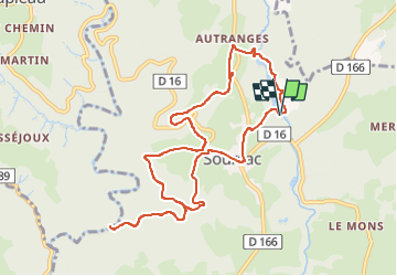
Tour Wandern von 10,5 km verfügbar auf Neu-Aquitanien, Corrèze, Soursac. Diese Tour wird von jagarnier vorgeschlagen.
Beschreibung
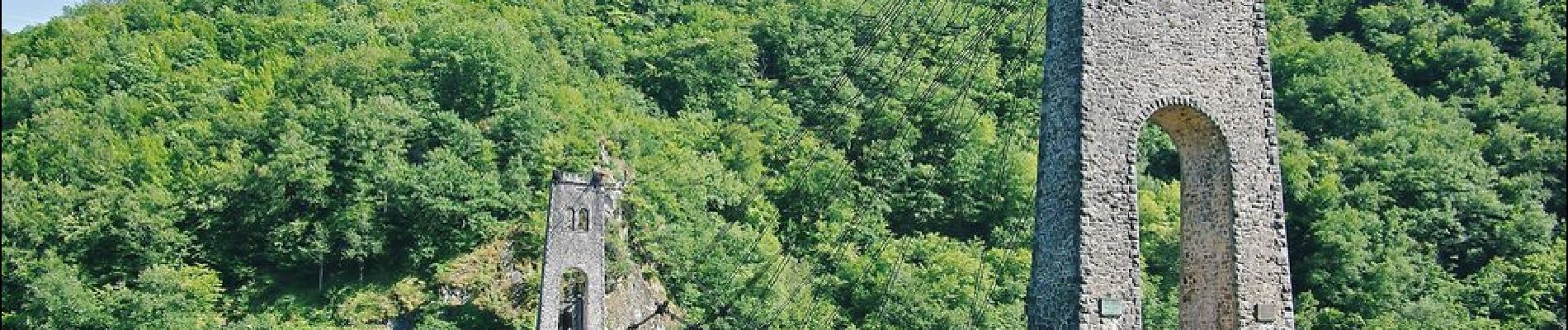
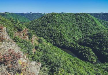
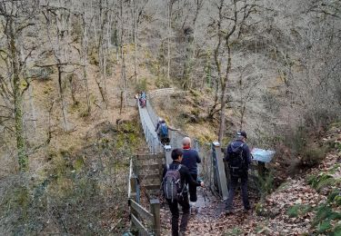
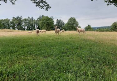
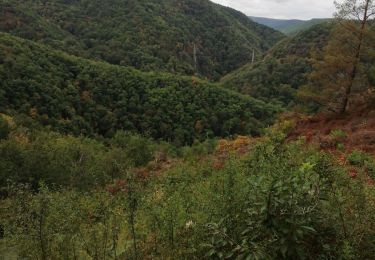
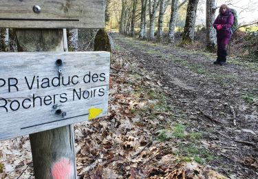
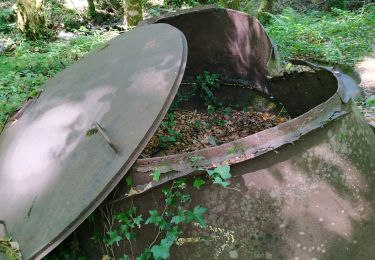
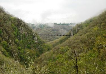
Vous partirez à la découverte du patrimoine naturel de Soursac en partant du lac du Pont-Aubert. Vous suivrez la voie du Tacot. Vous passerez par le Jardin de Firmin et sa cabane, qui offre une vue imprenable sur la Vallée de la Luzège. Ensuite, vous rejoindrez le viaduc des Rochers Noirs, construit entre 1911 et 1913 et aujourd’hui classé Monument Historique.
Ort
Kommentare
Touren in der Umgebung
![Tour Wandern Saint-Pantaléon-de-Lapleau - St Pantaleon_Luzeche - Photo](https://media.geolcdn.com/t/375/260/34576bdf-919b-48af-9826-42c86b9ec9ee.jpg&format=jpg&maxdim=2)
![Wandern Wandern](https://static1.geolcdn.com/sitytour/trail-icons/101.png)
Wandern
![](/images/other/stat-length.png)
![](https://static1.geolcdn.com/siteimages/upload/files/16400158638029165_repeat_loop_refresh_sync_direction_icon.png)
![Tour Wandern Soursac - Soursac_Spontour - Photo](https://media.geolcdn.com/t/375/260/2c029f0d-195a-4ddf-bf38-4d0cdf096c02.jpg&format=jpg&maxdim=2)
![Wandern Wandern](https://static1.geolcdn.com/sitytour/trail-icons/101.png)
Wandern
![](/images/other/stat-length.png)
![](https://static1.geolcdn.com/siteimages/upload/files/16400158638029165_repeat_loop_refresh_sync_direction_icon.png)
![Tour Wandern Lapleau - Viaduc des pierres noires depuis Lapleau - Photo](https://media.geolcdn.com/t/375/260/ffa71253-2e5c-4876-9cd9-66930580b9eb.jpg&format=jpg&maxdim=2)
![Wandern Wandern](https://static1.geolcdn.com/sitytour/trail-icons/101.png)
Wandern
![](/images/other/stat-length.png)
![](https://static1.geolcdn.com/siteimages/upload/files/16400158638029165_repeat_loop_refresh_sync_direction_icon.png)
![Tour Wandern Lapleau - passerelle 1 - Photo](https://media.geolcdn.com/t/375/260/e9af52c5-4ad0-4617-8e86-33ea030733a1.jpg&format=jpg&maxdim=2)
![Wandern Wandern](https://static1.geolcdn.com/sitytour/trail-icons/101.png)
Wandern
![](/images/other/stat-length.png)
![](https://static1.geolcdn.com/siteimages/upload/files/16400158638029165_repeat_loop_refresh_sync_direction_icon.png)
![Tour Wandern Chalvignac - 20210617 Chalvignac - Photo](https://media.geolcdn.com/t/375/260/39bebeba-a45b-459c-a345-c77001da0b1a.jpg&format=jpg&maxdim=2)
![Wandern Wandern](https://static1.geolcdn.com/sitytour/trail-icons/101.png)
Wandern
![](/images/other/stat-length.png)
![](https://static1.geolcdn.com/siteimages/upload/files/16400158638029165_repeat_loop_refresh_sync_direction_icon.png)
![Tour Wandern Soursac - Fred les roches noires - Photo](https://media.geolcdn.com/t/375/260/ec608207-f431-49a6-82e4-f0bedcbf0990.jpg&format=jpg&maxdim=2)
![Wandern Wandern](https://static1.geolcdn.com/sitytour/trail-icons/101.png)
Wandern
![](/images/other/stat-length.png)
![](https://static1.geolcdn.com/siteimages/upload/files/16400158638029165_repeat_loop_refresh_sync_direction_icon.png)
![Tour Wandern Lapleau - viaduc rochers noirs - Photo](https://media.geolcdn.com/t/375/260/9761b47e-b9e1-4080-a5c7-3102395a98fa.jpg&format=jpg&maxdim=2)
![Wandern Wandern](https://static1.geolcdn.com/sitytour/trail-icons/101.png)
Wandern
![](/images/other/stat-length.png)
![](https://static1.geolcdn.com/siteimages/upload/files/16400158638029165_repeat_loop_refresh_sync_direction_icon.png)
![Tour Wandern Soursac - cascade du saut sali - Photo](https://media.geolcdn.com/t/375/260/5aebf59d-9ca1-4544-a140-ca44d293c988.jpg&format=jpg&maxdim=2)
![Wandern Wandern](https://static1.geolcdn.com/sitytour/trail-icons/101.png)
Wandern
![](/images/other/stat-length.png)
![](https://static1.geolcdn.com/siteimages/upload/files/16400158638029165_repeat_loop_refresh_sync_direction_icon.png)
![Tour Wandern Soursac - Du plateau Soursacois aux gorges de la Luzège - Soursac - Pays de Haute Corrèze - Photo](https://media.geolcdn.com/t/375/260/ext.jpg?maxdim=2&url=https%3A%2F%2Fservices.sitytrail.com%2FGeolivesWS%2FDownloadMedia.ashx%3FTrailID%3D112407%26Media%3D10530_1.jpg)
![Wandern Wandern](https://static1.geolcdn.com/sitytour/trail-icons/101.png)
Wandern
![](/images/other/stat-length.png)
![](https://static1.geolcdn.com/siteimages/upload/files/16400158638029165_repeat_loop_refresh_sync_direction_icon.png)