![](/images/other/stat-length.png)
![Tour Andere Aktivitäten Nouzonville - VALLÉE DE NAIDIMONT - Photo](https://media.geolcdn.com/t/1900/400/ext.pjpeg?maxdim=2&url=https%3A%2F%2Fservices.sitytrail.com%2FGeolivesWS%2FDownloadMedia.ashx%3FTrailID%3D404469%26Media%3D20150406111253.jpg)
VALLÉE DE NAIDIMONT
PascalBanide
Benutzer
![Länge](/images/other/stat-length.png)
Länge
8,1 km
![Maximale Höhe](https://static1.geolcdn.com/siteimages/upload/files/1508320355ic_sort_altitude_max_24dp.png)
Maximale Höhe
330 m
![Positive Höhendifferenz](https://static1.geolcdn.com/siteimages/upload/files/1508320355ic_sort_den_pos_24dp.png)
Positive Höhendifferenz
204 m
![Km-Effort](/images/other/stat-length.png)
Km-Effort
10,8 km
![Min. Höhe](https://static1.geolcdn.com/siteimages/upload/files/1508320355ic_sort_altitude_min_24dp.png)
Min. Höhe
166 m
![Negative Höhendifferenz](https://static1.geolcdn.com/siteimages/upload/files/1508320355ic_sort_den_neg_24dp.png)
Negative Höhendifferenz
207 m
![Boucle](https://static1.geolcdn.com/siteimages/upload/files/16400158638029165_repeat_loop_refresh_sync_direction_icon.png)
Boucle
Ja
Erstellungsdatum :
2015-04-06 00:00:00.0
Letzte Änderung :
2015-04-06 00:00:00.0
![Andere Aktivitäten](https://static1.geolcdn.com/sitytour/trail-icons/900.png)
1h55
Schwierigkeit : Einfach
![Scannen Sie diesen QR-Code, um die Tour in der SityTrail-Anwendung zu öffnen](https://capi.geolives.com/qq0zvz2zws4bq2lad0pu/sitytour/trails/404469/qr.png?size=200)
Kostenlosegpshiking-Anwendung
Über SityTrail
Tour Andere Aktivitäten von 8,1 km verfügbar auf Großer Osten, Ardennes, Nouzonville. Diese Tour wird von PascalBanide vorgeschlagen.
Beschreibung
Balade tranquille le long du ruisseau et étangs puis montée dans les bois vers le village Le Maroc.
Ort
Land:
France
Region :
Großer Osten
Abteilung/Provinz :
Ardennes
Kommune :
Nouzonville
Standort:
Nouzonville
Gehen Sie:(Dec)
Gehen Sie:(UTM)
627032 ; 5520191 (31U) N.
Kommentare
Touren in der Umgebung
![Tour Wandern Haulmé - Thilay - Haulmé - Navaux - Photo](https://media.geolcdn.com/t/375/260/ext.jpg?maxdim=2&url=https%3A%2F%2Fservices.sitytrail.com%2FGeolivesWS%2FDownloadMedia.ashx%3FTrailID%3D214837%26Media%3D15355_6.jpg)
![Wandern Wandern](https://static1.geolcdn.com/sitytour/trail-icons/101.png)
Thilay - Haulmé - Navaux
Wandern
Medium
(3)
Haulmé,
Großer Osten,
Ardennes,
France
![](/images/other/stat-length.png)
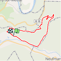
15,3 km | 21 km-effort
3h 15min
![](https://static1.geolcdn.com/siteimages/upload/files/16400158638029165_repeat_loop_refresh_sync_direction_icon.png)
Ja
![Tour Wandern Nouzonville - Rando. Nouzonville FFSP - Photo](https://media.geolcdn.com/t/375/260/ext.jpg?maxdim=2&url=https%3A%2F%2Fservices.sitytrail.com%2FGeolivesWS%2FDownloadMedia.ashx%3FTrailID%3D756986%26Media%3D20170521131908.jpg)
![Wandern Wandern](https://static1.geolcdn.com/sitytour/trail-icons/101.png)
Rando. Nouzonville FFSP
Wandern
Medium
(1)
Nouzonville,
Großer Osten,
Ardennes,
France
![](/images/other/stat-length.png)
15,9 km | 21 km-effort
3h 55min
![](https://static1.geolcdn.com/siteimages/upload/files/16400158638029165_repeat_loop_refresh_sync_direction_icon.png)
Ja
![Tour Wandern Bogny-sur-Meuse - La promenade du Liry et des Quatre Fils Aymon - Photo](https://media.geolcdn.com/t/375/260/ext.jpg?maxdim=2&url=https%3A%2F%2Fstatic1.geolcdn.com%2Fsiteimages%2Fupload%2Ffiles%2F1553511878bg_sport_marche.png)
![Wandern Wandern](https://static1.geolcdn.com/sitytour/trail-icons/101.png)
La promenade du Liry et des Quatre Fils Aymon
Wandern
Medium
(1)
Bogny-sur-Meuse,
Großer Osten,
Ardennes,
France
![](/images/other/stat-length.png)
11,4 km | 16,9 km-effort
3h 0min
![](https://static1.geolcdn.com/siteimages/upload/files/16400158638029165_repeat_loop_refresh_sync_direction_icon.png)
Ja
![Tour Andere Aktivitäten Nouzonville - Balade VTT sympa - Photo](https://media.geolcdn.com/t/375/260/ext.jpg?maxdim=2&url=https%3A%2F%2Fstatic1.geolcdn.com%2Fsiteimages%2Fupload%2Ffiles%2F1545311037marcheuse_200dpi.jpg)
![Andere Aktivitäten Andere Aktivitäten](https://static1.geolcdn.com/sitytour/trail-icons/900.png)
Balade VTT sympa
Andere Aktivitäten
Einfach
(1)
Nouzonville,
Großer Osten,
Ardennes,
France
![](/images/other/stat-length.png)
11,7 km | 13,8 km-effort
1h 18min
![](https://static1.geolcdn.com/siteimages/upload/files/16400158638029165_repeat_loop_refresh_sync_direction_icon.png)
Ja
![Tour Wandern Gespunsart - Gespunsart 110324 - Photo](https://media.geolcdn.com/t/375/260/983592c9-ed59-484b-ab3f-739543686869.jpg&format=jpg&maxdim=2)
![Wandern Wandern](https://static1.geolcdn.com/sitytour/trail-icons/101.png)
Gespunsart 110324
Wandern
Medium
Gespunsart,
Großer Osten,
Ardennes,
France
![](/images/other/stat-length.png)
19 km | 24 km-effort
4h 17min
![](https://static1.geolcdn.com/siteimages/upload/files/16400158638029165_repeat_loop_refresh_sync_direction_icon.png)
Ja
![Tour Wandern Charleville-Mézières - De Charleville Mézières à Olly (Commune d'Illy) - Photo](https://media.geolcdn.com/t/375/260/7d73bd6e-f0b7-4726-8c94-18c6cbf615f3.jpg&format=jpg&maxdim=2)
![Wandern Wandern](https://static1.geolcdn.com/sitytour/trail-icons/101.png)
De Charleville Mézières à Olly (Commune d'Illy)
Wandern
Medium
Charleville-Mézières,
Großer Osten,
Ardennes,
France
![](/images/other/stat-length.png)
28 km | 33 km-effort
8h 20min
![](https://static1.geolcdn.com/siteimages/upload/files/16400158638029165_repeat_loop_refresh_sync_direction_icon.png)
Nein
![Tour Wandern Nouzonville - meillier fontaine chemin bleu les hutins - Photo](https://media.geolcdn.com/t/375/260/a7997afe-ad91-40f9-8281-ae2d76fc1e99.jpg&format=jpg&maxdim=2)
![Wandern Wandern](https://static1.geolcdn.com/sitytour/trail-icons/101.png)
meillier fontaine chemin bleu les hutins
Wandern
Medium
Nouzonville,
Großer Osten,
Ardennes,
France
![](/images/other/stat-length.png)
8,6 km | 11,8 km-effort
2h 40min
![](https://static1.geolcdn.com/siteimages/upload/files/16400158638029165_repeat_loop_refresh_sync_direction_icon.png)
Ja
![Tour Wandern Neufmanil - 2022-01-10_15h31m44_SityTrail - 2331539 - neufmanil-2020x02x11 - Photo](https://media.geolcdn.com/t/375/260/ext.jpg?maxdim=2&url=https%3A%2F%2Fstatic1.geolcdn.com%2Fsiteimages%2Fupload%2Ffiles%2F1553511878bg_sport_marche.png)
![Wandern Wandern](https://static1.geolcdn.com/sitytour/trail-icons/101.png)
2022-01-10_15h31m44_SityTrail - 2331539 - neufmanil-2020x02x11
Wandern
Sehr schwierig
(1)
Neufmanil,
Großer Osten,
Ardennes,
France
![](/images/other/stat-length.png)
14,1 km | 19,1 km-effort
4h 20min
![](https://static1.geolcdn.com/siteimages/upload/files/16400158638029165_repeat_loop_refresh_sync_direction_icon.png)
Ja
![Tour Wandern Charleville-Mézières - la havetiere CHM - Photo](https://media.geolcdn.com/t/375/260/c5f7d70f-e79d-4044-a8a3-c9b0a21efbd5.jpg&format=jpg&maxdim=2)
![Wandern Wandern](https://static1.geolcdn.com/sitytour/trail-icons/101.png)
la havetiere CHM
Wandern
Einfach
Charleville-Mézières,
Großer Osten,
Ardennes,
France
![](/images/other/stat-length.png)
10,5 km | 14 km-effort
2h 41min
![](https://static1.geolcdn.com/siteimages/upload/files/16400158638029165_repeat_loop_refresh_sync_direction_icon.png)
Ja