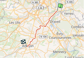
![](/images/other/stat-length.png)
![Tour Ablon-sur-Seine - 2024-05-01_20h40m45_94xl7-18-la-promenade-de-l-orge-29-km-par-jean-luc-ibp-70 (1) - Photo](https://media.geolcdn.com/t/1900/400/ext.pjpeg?maxdim=2&url=https%3A%2F%2Fsecurestorage.geolives.com%2Fsitytour%2Ftrail-bg%2Fdefault.jpg)
2024-05-01_20h40m45_94xl7-18-la-promenade-de-l-orge-29-km-par-jean-luc-ibp-70 (1)
jpryerres
Benutzer
![Länge](/images/other/stat-length.png)
![Maximale Höhe](https://static1.geolcdn.com/siteimages/upload/files/1508320355ic_sort_altitude_max_24dp.png)
![Positive Höhendifferenz](https://static1.geolcdn.com/siteimages/upload/files/1508320355ic_sort_den_pos_24dp.png)
![Km-Effort](/images/other/stat-length.png)
![Min. Höhe](https://static1.geolcdn.com/siteimages/upload/files/1508320355ic_sort_altitude_min_24dp.png)
![Negative Höhendifferenz](https://static1.geolcdn.com/siteimages/upload/files/1508320355ic_sort_den_neg_24dp.png)
![Boucle](https://static1.geolcdn.com/siteimages/upload/files/16400158638029165_repeat_loop_refresh_sync_direction_icon.png)
![Scannen Sie diesen QR-Code, um die Tour in der SityTrail-Anwendung zu öffnen](https://capi.geolives.com/qq0zvz2zws4bq2lad0pu/sitytour/trails/4036743/qr.png?size=200)
Kostenlosegpshiking-Anwendung
Über SityTrail
Tour von 29 km verfügbar auf Île-de-France, Val-de-Marne, Ablon-sur-Seine. Diese Tour wird von jpryerres vorgeschlagen.
Beschreibung
[img]https://4.bp.blogspot.com/-CBUmrUw11Uo/Wtr_c5QVTSI/AAAAAAAAPL4/18f8zkojvuQ3yH17tt2Md3CAeGiWpXpOQCLcBGAs/s1600/RONG-ConvertImage.icoo[/img] [b]Rando Club Yerrois[/b]
[img]https://4.bp.blogspot.com/-CBUmrUw11Uo/Wtr_c5QVTSI/AAAAAAAAPL4/18f8zkojvuQ3yH17tt2Md3CAeGiWpXpOQCLcBGAs/s1600/RONG-ConvertImage.icoo[/img] [b]Rando Club Yerrois[/b]
[b]Date[/b] : Dimanche 28 Janvier 2018
[b]Animateur[/b] : Jean Luc
[b]Groupe[/b] : 30 km
[b]Effectif[/b] : 10aine
[b]Vidéo relive[/b] :[url]https://youtu.be/ospD69my1a0[/url]
[b]Remarque particulière[/b] : Départ d'Ablon (parking difficile et probablement impossible en semaine ) et retour par le train depuis Arpajon (3 euros 50)
[b]Avertissement[/b] Toutes les randonnées répertoriées dans la randothèque du [b]R[/b]ando [b]C[/b]lub [b]Y[/b]errois ont été tracées par l'un de nos animateurs, puis reconnues et enfin effectuées avec un groupe. Pour votre sécurité, regardez toujours la date à laquelle la sortie a été effectuée - Nous tachons de mentionner des conditions météos particulières ou les difficultés éventuelles. N'oubliez jamais les consignes élémentaires de sécurité.
Ort
Kommentare
Touren in der Umgebung
![Tour Wandern Juvisy-sur-Orge - GRP CV-IDF 2023 - Photo](https://media.geolcdn.com/t/375/260/fc32371e-a9db-4ebb-87ec-b0b2ec43c0ff.jpg&format=jpg&maxdim=2)
![Wandern Wandern](https://static1.geolcdn.com/sitytour/trail-icons/101.png)
Wandern
![](/images/other/stat-length.png)
![](https://static1.geolcdn.com/siteimages/upload/files/16400158638029165_repeat_loop_refresh_sync_direction_icon.png)
![Tour Wandern Montgeron - J 38 Montgeron la Pelouse, forêt de Sénart - Photo](https://media.geolcdn.com/t/375/260/f009853b-b232-40f1-8161-c380b5b5f65c.jpg&format=jpg&maxdim=2)
![Wandern Wandern](https://static1.geolcdn.com/sitytour/trail-icons/101.png)
Wandern
![](/images/other/stat-length.png)
![](https://static1.geolcdn.com/siteimages/upload/files/16400158638029165_repeat_loop_refresh_sync_direction_icon.png)
![Tour Wandern Yerres - Marathon Rcy 2025 Yerres - Brie - Photo](https://media.geolcdn.com/t/375/260/9e9ae917-97b6-4c50-a6d8-c127e19a6bb4.jpg&format=jpg&maxdim=2)
![Wandern Wandern](https://static1.geolcdn.com/sitytour/trail-icons/101.png)
Wandern
![](/images/other/stat-length.png)
![](https://static1.geolcdn.com/siteimages/upload/files/16400158638029165_repeat_loop_refresh_sync_direction_icon.png)
![Tour Wandern Yerres - Boucle 30 km Sénart et bords de l'YERRES - Photo](https://media.geolcdn.com/t/375/260/fbf9994b-859d-4be0-b50d-9a375c8ecfa7.jpg&format=jpg&maxdim=2)
![Wandern Wandern](https://static1.geolcdn.com/sitytour/trail-icons/101.png)
Wandern
![](/images/other/stat-length.png)
![](https://static1.geolcdn.com/siteimages/upload/files/16400158638029165_repeat_loop_refresh_sync_direction_icon.png)
![Tour Wandern Draveil - Port aux Cerises - Ablon 21 km - Photo](https://media.geolcdn.com/t/375/260/ext.jpg?maxdim=2&url=https%3A%2F%2Fstatic1.geolcdn.com%2Fsiteimages%2Fupload%2Ffiles%2F1553511878bg_sport_marche.png)
![Wandern Wandern](https://static1.geolcdn.com/sitytour/trail-icons/101.png)
Wandern
![](/images/other/stat-length.png)
![](https://static1.geolcdn.com/siteimages/upload/files/16400158638029165_repeat_loop_refresh_sync_direction_icon.png)
![Tour Wandern Yerres - marathon RCY 2023 - Photo](https://media.geolcdn.com/t/375/260/d33e9aa0-1a62-4be6-9f3c-7c3740cb003e.jpg&format=jpg&maxdim=2)
![Wandern Wandern](https://static1.geolcdn.com/sitytour/trail-icons/101.png)
Wandern
![](/images/other/stat-length.png)
![](https://static1.geolcdn.com/siteimages/upload/files/16400158638029165_repeat_loop_refresh_sync_direction_icon.png)
![Tour Wandern Yerres - Boucle Yerres - Réveillon- Bois de la Grange - 12 km - Photo](https://media.geolcdn.com/t/375/260/ext.jpg?maxdim=2&url=https%3A%2F%2Fstatic1.geolcdn.com%2Fsiteimages%2Fupload%2Ffiles%2F1553511878bg_sport_marche.png)
![Wandern Wandern](https://static1.geolcdn.com/sitytour/trail-icons/101.png)
Wandern
![](/images/other/stat-length.png)
![](https://static1.geolcdn.com/siteimages/upload/files/16400158638029165_repeat_loop_refresh_sync_direction_icon.png)
![Tour Wandern Yerres - Yerres - Montgeron - Brunoy 11,5 km - Photo](https://media.geolcdn.com/t/375/260/ext.jpg?maxdim=2&url=https%3A%2F%2Fstatic1.geolcdn.com%2Fsiteimages%2Fupload%2Ffiles%2F1553511878bg_sport_marche.png)
![Wandern Wandern](https://static1.geolcdn.com/sitytour/trail-icons/101.png)
Wandern
![](/images/other/stat-length.png)
![](https://static1.geolcdn.com/siteimages/upload/files/16400158638029165_repeat_loop_refresh_sync_direction_icon.png)
![Tour Wandern Créteil - Parc départemental et tour lac Créteil 15 km - Photo](https://media.geolcdn.com/t/375/260/ext.jpg?maxdim=2&url=https%3A%2F%2Fstatic1.geolcdn.com%2Fsiteimages%2Fupload%2Ffiles%2F1553511878bg_sport_marche.png)
![Wandern Wandern](https://static1.geolcdn.com/sitytour/trail-icons/101.png)
Wandern
![](/images/other/stat-length.png)
![](https://static1.geolcdn.com/siteimages/upload/files/16400158638029165_repeat_loop_refresh_sync_direction_icon.png)