![](/images/other/stat-length.png)
![Tour Wandern Fournels - ATPC Fournels_Les Thermes_Fournels 2019-08-25 - Photo](https://media.geolcdn.com/t/1900/400/ext.pjpeg?maxdim=2&url=https%3A%2F%2Fstatic1.geolcdn.com%2Fsiteimages%2Fupload%2Ffiles%2F1553511878bg_sport_marche.png)
ATPC Fournels_Les Thermes_Fournels 2019-08-25
raymondfn
Benutzer
![Länge](/images/other/stat-length.png)
Länge
11,9 km
![Maximale Höhe](https://static1.geolcdn.com/siteimages/upload/files/1508320355ic_sort_altitude_max_24dp.png)
Maximale Höhe
1197 m
![Positive Höhendifferenz](https://static1.geolcdn.com/siteimages/upload/files/1508320355ic_sort_den_pos_24dp.png)
Positive Höhendifferenz
332 m
![Km-Effort](/images/other/stat-length.png)
Km-Effort
16,4 km
![Min. Höhe](https://static1.geolcdn.com/siteimages/upload/files/1508320355ic_sort_altitude_min_24dp.png)
Min. Höhe
957 m
![Negative Höhendifferenz](https://static1.geolcdn.com/siteimages/upload/files/1508320355ic_sort_den_neg_24dp.png)
Negative Höhendifferenz
332 m
![Boucle](https://static1.geolcdn.com/siteimages/upload/files/16400158638029165_repeat_loop_refresh_sync_direction_icon.png)
Boucle
Ja
Erstellungsdatum :
2024-04-26 16:50:07.402
Letzte Änderung :
2024-05-26 12:33:10.392
![Wandern](https://static1.geolcdn.com/sitytour/trail-icons/101.png)
3h42
Schwierigkeit : Schwierig
![Scannen Sie diesen QR-Code, um die Tour in der SityTrail-Anwendung zu öffnen](https://capi.geolives.com/qq0zvz2zws4bq2lad0pu/sitytour/trails/4030746/qr.png?size=200)
Kostenlosegpshiking-Anwendung
Über SityTrail
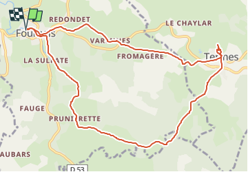
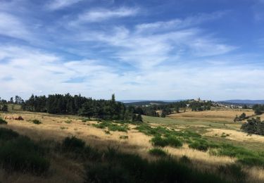
Tour Wandern von 11,9 km verfügbar auf Okzitanien, Lozère, Fournels. Diese Tour wird von raymondfn vorgeschlagen.
Beschreibung
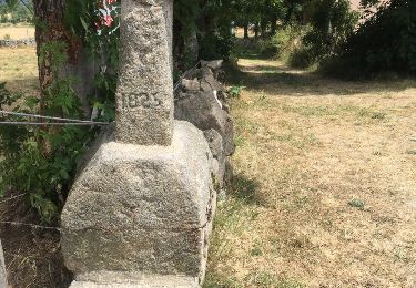
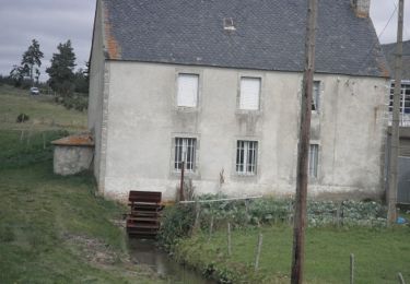
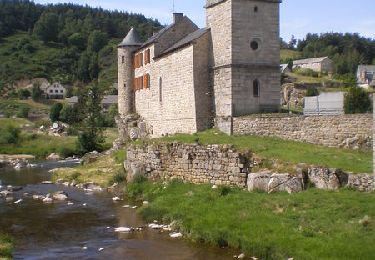
Passer devant l'Eglise et gagner le GR de Pays du Tour des monts d'Aubrac et aller jusqu'à Pruniérette. Rester sur ce GR jusqu'à Termes. A Termes, revenir vers le calvaire et prendre le PR à droite en direction de Varennes, puis le Mazet et enfin Fournels.
Ort
Land:
France
Region :
Okzitanien
Abteilung/Provinz :
Lozère
Kommune :
Fournels
Standort:
Unknown
Gehen Sie:(Dec)
Gehen Sie:(UTM)
509329 ; 4962732 (31T) N.
Kommentare
Touren in der Umgebung
![Tour Zu Fuß Chauchailles - 2022-05-31_19h34m27_gpx-trace - Photo](https://media.geolcdn.com/t/375/260/ext.jpg?maxdim=2&url=https%3A%2F%2Fstatic1.geolcdn.com%2Fsiteimages%2Fupload%2Ffiles%2F1545311037marcheuse_200dpi.jpg)
![Zu Fuß Zu Fuß](https://static1.geolcdn.com/sitytour/trail-icons/100.png)
2022-05-31_19h34m27_gpx-trace
Zu Fuß
Schwierig
(1)
Chauchailles,
Okzitanien,
Lozère,
France
![](/images/other/stat-length.png)
22 km | 31 km-effort
7h 7min
![](https://static1.geolcdn.com/siteimages/upload/files/16400158638029165_repeat_loop_refresh_sync_direction_icon.png)
Ja
![Tour Wandern Chauchailles - sentier des espagnols - Photo](https://media.geolcdn.com/t/375/260/3a0f3874-78ce-48ea-a436-24dea33476d2.jpg&format=jpg&maxdim=2)
![Wandern Wandern](https://static1.geolcdn.com/sitytour/trail-icons/101.png)
sentier des espagnols
Wandern
Schwierig
Chauchailles,
Okzitanien,
Lozère,
France
![](/images/other/stat-length.png)
22 km | 32 km-effort
6h 48min
![](https://static1.geolcdn.com/siteimages/upload/files/16400158638029165_repeat_loop_refresh_sync_direction_icon.png)
Ja
![Tour Wandern Chauchailles - Gorges du Bèz sentier des espagnols - Photo](https://media.geolcdn.com/t/375/260/9def8888-645c-4270-a3bb-b3f990eb7ef3.jpg&format=jpg&maxdim=2)
![Wandern Wandern](https://static1.geolcdn.com/sitytour/trail-icons/101.png)
Gorges du Bèz sentier des espagnols
Wandern
Sehr schwierig
Chauchailles,
Okzitanien,
Lozère,
France
![](/images/other/stat-length.png)
22 km | 31 km-effort
7h 34min
![](https://static1.geolcdn.com/siteimages/upload/files/16400158638029165_repeat_loop_refresh_sync_direction_icon.png)
Ja
![Tour Wandern Termes - Termes Aumont aubrac - Photo](https://media.geolcdn.com/t/375/260/f87d16b1-1f73-4a88-8df5-61d0347ec4b8.jpg&format=jpg&maxdim=2)
![Wandern Wandern](https://static1.geolcdn.com/sitytour/trail-icons/101.png)
Termes Aumont aubrac
Wandern
Medium
Termes,
Okzitanien,
Lozère,
France
![](/images/other/stat-length.png)
19,1 km | 23 km-effort
7h 22min
![](https://static1.geolcdn.com/siteimages/upload/files/16400158638029165_repeat_loop_refresh_sync_direction_icon.png)
Nein
![Tour Wandern Termes - TERMES 48 - autour de la Rau de la FAGE - Photo](https://media.geolcdn.com/t/375/260/ext.jpg?maxdim=2&url=https%3A%2F%2Fservices.sitytrail.com%2FGeolivesWS%2FDownloadMedia.ashx%3FTrailID%3D445928%26Media%3D20150715150322.jpg)
![Wandern Wandern](https://static1.geolcdn.com/sitytour/trail-icons/101.png)
TERMES 48 - autour de la Rau de la FAGE
Wandern
Medium
Termes,
Okzitanien,
Lozère,
France
![](/images/other/stat-length.png)
12,2 km | 15,4 km-effort
2h 36min
![](https://static1.geolcdn.com/siteimages/upload/files/16400158638029165_repeat_loop_refresh_sync_direction_icon.png)
Ja
![Tour Wandern Termes - TERMES 48 - petit circuit - Photo](https://media.geolcdn.com/t/375/260/ext.jpg?maxdim=2&url=https%3A%2F%2Fservices.sitytrail.com%2FGeolivesWS%2FDownloadMedia.ashx%3FTrailID%3D445926%26Media%3D20150712174806.jpg)
![Wandern Wandern](https://static1.geolcdn.com/sitytour/trail-icons/101.png)
TERMES 48 - petit circuit
Wandern
Einfach
(1)
Termes,
Okzitanien,
Lozère,
France
![](/images/other/stat-length.png)
7,3 km | 8,8 km-effort
1h 46min
![](https://static1.geolcdn.com/siteimages/upload/files/16400158638029165_repeat_loop_refresh_sync_direction_icon.png)
Ja
![Tour Wandern Fournels - De Fournels à St-Chély-d'Apcher - Photo](https://media.geolcdn.com/t/375/260/ext.jpg?maxdim=2&url=https%3A%2F%2Fservices.sitytrail.com%2FGeolivesWS%2FDownloadMedia.ashx%3FTrailID%3D172923%26Media%3D14391_4.jpg)
![Wandern Wandern](https://static1.geolcdn.com/sitytour/trail-icons/101.png)
De Fournels à St-Chély-d'Apcher
Wandern
Schwierig
Fournels,
Okzitanien,
Lozère,
France
![](/images/other/stat-length.png)
17,7 km | 23 km-effort
4h 10min
![](https://static1.geolcdn.com/siteimages/upload/files/16400158638029165_repeat_loop_refresh_sync_direction_icon.png)
Nein
![Tour Wandern Chauchailles - Les Gorges du Bes - Photo](https://media.geolcdn.com/t/375/260/ext.jpg?maxdim=2&url=https%3A%2F%2Fservices.sitytrail.com%2FGeolivesWS%2FDownloadMedia.ashx%3FTrailID%3D103575%26Media%3D5887_6.jpg)
![Wandern Wandern](https://static1.geolcdn.com/sitytour/trail-icons/101.png)
Les Gorges du Bes
Wandern
Schwierig
(1)
Chauchailles,
Okzitanien,
Lozère,
France
![](/images/other/stat-length.png)
21 km | 30 km-effort
7h 0min
![](https://static1.geolcdn.com/siteimages/upload/files/16400158638029165_repeat_loop_refresh_sync_direction_icon.png)
Ja
![Tour Wandern Chauchailles - les Gorges du Bes - Photo](https://media.geolcdn.com/t/375/260/c987b7ea-518c-4395-9a06-f2e4d18857b3.jpg&format=jpg&maxdim=2)
![Wandern Wandern](https://static1.geolcdn.com/sitytour/trail-icons/101.png)
les Gorges du Bes
Wandern
Medium
Chauchailles,
Okzitanien,
Lozère,
France
![](/images/other/stat-length.png)
15,3 km | 21 km-effort
7h 7min
![](https://static1.geolcdn.com/siteimages/upload/files/16400158638029165_repeat_loop_refresh_sync_direction_icon.png)
Ja