![](/images/other/stat-length.png)
![Tour Mountainbike Mézel - MEZEL - Photo](https://media.geolcdn.com/t/1900/400/5bd6dcd4-20ec-453d-94a1-d3e68a1766a0.jpg&format=pjpeg&maxdim=2)
MEZEL
jean marc canu
Benutzer
![Länge](/images/other/stat-length.png)
Länge
56 km
![Maximale Höhe](https://static1.geolcdn.com/siteimages/upload/files/1508320355ic_sort_altitude_max_24dp.png)
Maximale Höhe
1359 m
![Positive Höhendifferenz](https://static1.geolcdn.com/siteimages/upload/files/1508320355ic_sort_den_pos_24dp.png)
Positive Höhendifferenz
1277 m
![Km-Effort](/images/other/stat-length.png)
Km-Effort
73 km
![Min. Höhe](https://static1.geolcdn.com/siteimages/upload/files/1508320355ic_sort_altitude_min_24dp.png)
Min. Höhe
509 m
![Negative Höhendifferenz](https://static1.geolcdn.com/siteimages/upload/files/1508320355ic_sort_den_neg_24dp.png)
Negative Höhendifferenz
1277 m
![Boucle](https://static1.geolcdn.com/siteimages/upload/files/16400158638029165_repeat_loop_refresh_sync_direction_icon.png)
Boucle
Ja
Erstellungsdatum :
2024-04-21 07:53:49.975
Letzte Änderung :
2024-04-26 08:16:21.437
![Mountainbike](https://static1.geolcdn.com/sitytour/trail-icons/202.png)
5h05
Schwierigkeit : Sehr schwierig
![Scannen Sie diesen QR-Code, um die Tour in der SityTrail-Anwendung zu öffnen](https://capi.geolives.com/qq0zvz2zws4bq2lad0pu/sitytour/trails/4024979/qr.png?size=200)
Kostenlosegpshiking-Anwendung
Über SityTrail
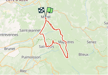
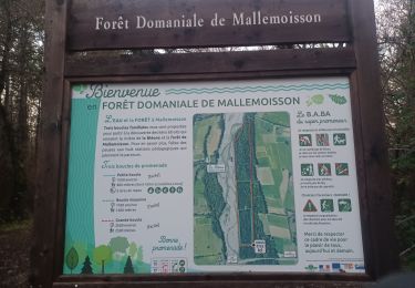
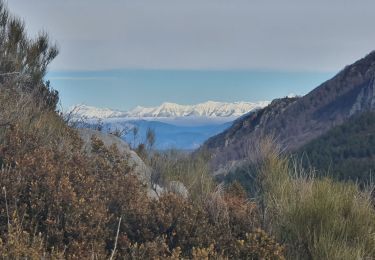
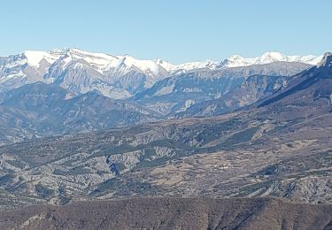
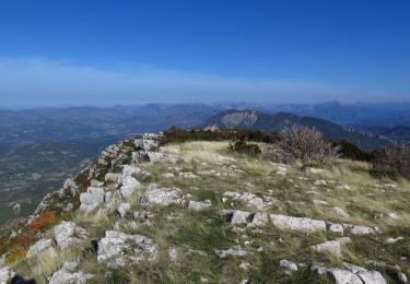
Tour Mountainbike von 56 km verfügbar auf Provence-Alpes-Côte d'Azur, Alpes-de-Haute-Provence, Mézel. Diese Tour wird von jean marc canu vorgeschlagen.
Beschreibung
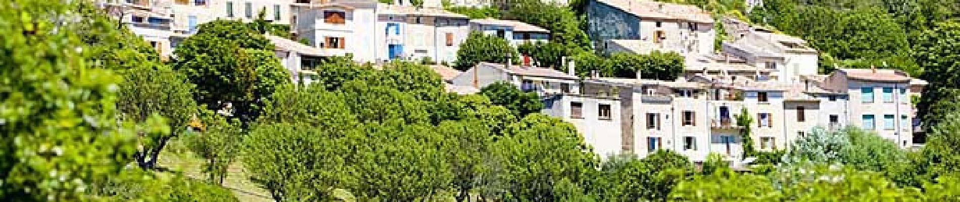
MEZEL. PALUS. LE POIL. MAJASTRES. COL DE ST JURS. ST JURS VILLAGE. ESTOUBLON. MEZEL.
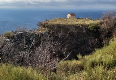
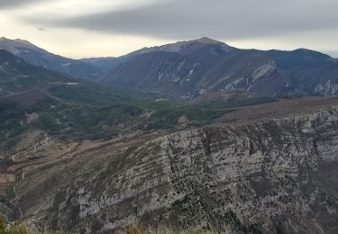
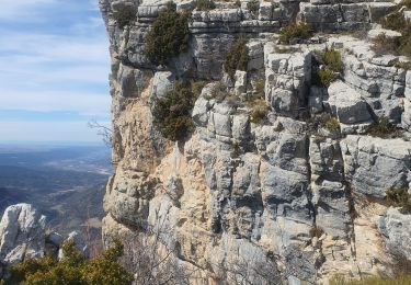
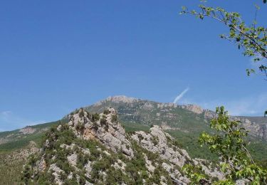
magnifique randonnee inoubliable dans le parc du Verdon
Ort
Land:
France
Region :
Provence-Alpes-Côte d'Azur
Abteilung/Provinz :
Alpes-de-Haute-Provence
Kommune :
Mézel
Standort:
Unknown
Gehen Sie:(Dec)
Gehen Sie:(UTM)
275185 ; 4875292 (32T) N.
Kommentare
Touren in der Umgebung
![Tour Wandern Entrages - Digne cousson courtiers 937m 15kms - Photo](https://media.geolcdn.com/t/375/260/cc588e67-50fc-4ee9-8cc3-a13b0a81a85e.jpg&format=jpg&maxdim=2)
![Wandern Wandern](https://static1.geolcdn.com/sitytour/trail-icons/101.png)
Digne cousson courtiers 937m 15kms
Wandern
Einfach
Entrages,
Provence-Alpes-Côte d'Azur,
Alpes-de-Haute-Provence,
France
![](/images/other/stat-length.png)
14,1 km | 26 km-effort
6h 35min
![](https://static1.geolcdn.com/siteimages/upload/files/16400158638029165_repeat_loop_refresh_sync_direction_icon.png)
Ja
![Tour Wandern Beynes - Montagne de Beynes 11kms 720m - Photo](https://media.geolcdn.com/t/375/260/0924528c-4d8c-48ab-ad20-f85077c2766f.jpg&format=jpg&maxdim=2)
![Wandern Wandern](https://static1.geolcdn.com/sitytour/trail-icons/101.png)
Montagne de Beynes 11kms 720m
Wandern
Sehr schwierig
Beynes,
Provence-Alpes-Côte d'Azur,
Alpes-de-Haute-Provence,
France
![](/images/other/stat-length.png)
11 km | 21 km-effort
6h 28min
![](https://static1.geolcdn.com/siteimages/upload/files/16400158638029165_repeat_loop_refresh_sync_direction_icon.png)
Ja
![Tour Wandern Mallemoisson - MALLEMOISSON . A LA DÉCOUVERTE DE MALLEMOISSON . N - Photo](https://media.geolcdn.com/t/375/260/9bf7e860-0303-464c-9f50-bd1deaa68b13.jpg&format=jpg&maxdim=2)
![Wandern Wandern](https://static1.geolcdn.com/sitytour/trail-icons/101.png)
MALLEMOISSON . A LA DÉCOUVERTE DE MALLEMOISSON . N
Wandern
Medium
Mallemoisson,
Provence-Alpes-Côte d'Azur,
Alpes-de-Haute-Provence,
France
![](/images/other/stat-length.png)
11,1 km | 15,1 km-effort
3h 4min
![](https://static1.geolcdn.com/siteimages/upload/files/16400158638029165_repeat_loop_refresh_sync_direction_icon.png)
Ja
![Tour Wandern Beynes - 2023-03-17 Montagne de Beyne - Photo](https://media.geolcdn.com/t/375/260/a2f9f9ce-2317-441f-8351-fbd6bbd22b1f.jpg&format=jpg&maxdim=2)
![Wandern Wandern](https://static1.geolcdn.com/sitytour/trail-icons/101.png)
2023-03-17 Montagne de Beyne
Wandern
Medium
Beynes,
Provence-Alpes-Côte d'Azur,
Alpes-de-Haute-Provence,
France
![](/images/other/stat-length.png)
14,4 km | 26 km-effort
6h 28min
![](https://static1.geolcdn.com/siteimages/upload/files/16400158638029165_repeat_loop_refresh_sync_direction_icon.png)
Ja
![Tour Wandern Beynes - 04 La montagne de Beynes (Variante 05/2022) - Photo](https://media.geolcdn.com/t/375/260/00ffcda8-2af0-4879-a93e-d3abe306c026.jpg&format=jpg&maxdim=2)
![Wandern Wandern](https://static1.geolcdn.com/sitytour/trail-icons/101.png)
04 La montagne de Beynes (Variante 05/2022)
Wandern
Medium
Beynes,
Provence-Alpes-Côte d'Azur,
Alpes-de-Haute-Provence,
France
![](/images/other/stat-length.png)
12,9 km | 23 km-effort
7h 15min
![](https://static1.geolcdn.com/siteimages/upload/files/16400158638029165_repeat_loop_refresh_sync_direction_icon.png)
Ja
![Tour Wandern Beynes - Boucle de Palus - Beynes - Photo](https://media.geolcdn.com/t/375/260/ext.jpg?maxdim=2&url=https%3A%2F%2Fservices.sitytrail.com%2FGeolivesWS%2FDownloadMedia.ashx%3FTrailID%3D107414%26Media%3D12326_5.jpg)
![Wandern Wandern](https://static1.geolcdn.com/sitytour/trail-icons/101.png)
Boucle de Palus - Beynes
Wandern
Medium
Beynes,
Provence-Alpes-Côte d'Azur,
Alpes-de-Haute-Provence,
France
![](/images/other/stat-length.png)
7,8 km | 11 km-effort
2h 0min
![](https://static1.geolcdn.com/siteimages/upload/files/16400158638029165_repeat_loop_refresh_sync_direction_icon.png)
Ja
![Tour Wandern Beynes - 2024-01-19 Montagne de Beynes - Photo](https://media.geolcdn.com/t/375/260/ea48c337-33c1-4794-a6e6-ec06229ce66c.jpg&format=jpg&maxdim=2)
![Wandern Wandern](https://static1.geolcdn.com/sitytour/trail-icons/101.png)
2024-01-19 Montagne de Beynes
Wandern
Schwierig
Beynes,
Provence-Alpes-Côte d'Azur,
Alpes-de-Haute-Provence,
France
![](/images/other/stat-length.png)
12,6 km | 23 km-effort
5h 13min
![](https://static1.geolcdn.com/siteimages/upload/files/16400158638029165_repeat_loop_refresh_sync_direction_icon.png)
Ja
![Tour Wandern Entrages - courtiers coussin pas d entrage bartassage - Photo](https://media.geolcdn.com/t/375/260/88c6d998-65c9-46e0-ba79-33b7d16993e7.jpg&format=jpg&maxdim=2)
![Wandern Wandern](https://static1.geolcdn.com/sitytour/trail-icons/101.png)
courtiers coussin pas d entrage bartassage
Wandern
Sehr schwierig
Entrages,
Provence-Alpes-Côte d'Azur,
Alpes-de-Haute-Provence,
France
![](/images/other/stat-length.png)
14,1 km | 27 km-effort
7h 24min
![](https://static1.geolcdn.com/siteimages/upload/files/16400158638029165_repeat_loop_refresh_sync_direction_icon.png)
Ja
![Wandern Wandern](https://static1.geolcdn.com/sitytour/trail-icons/101.png)
Montagne de Beynes
Wandern
Medium
Beynes,
Provence-Alpes-Côte d'Azur,
Alpes-de-Haute-Provence,
France
![](/images/other/stat-length.png)
10,7 km | 21 km-effort
4h 0min
![](https://static1.geolcdn.com/siteimages/upload/files/16400158638029165_repeat_loop_refresh_sync_direction_icon.png)
Ja