![](/images/other/stat-length.png)
![Tour Motor Villars-les-Dombes - Sortie Solex Villars HZD - Photo](https://media.geolcdn.com/t/1900/400/ext.pjpeg?maxdim=2&url=https%3A%2F%2Fstatic1.geolcdn.com%2Fsiteimages%2Fupload%2Ffiles%2F15247431544x4.jpg)
Sortie Solex Villars HZD
BGO
Benutzer
![Länge](/images/other/stat-length.png)
Länge
59 km
![Maximale Höhe](https://static1.geolcdn.com/siteimages/upload/files/1508320355ic_sort_altitude_max_24dp.png)
Maximale Höhe
300 m
![Positive Höhendifferenz](https://static1.geolcdn.com/siteimages/upload/files/1508320355ic_sort_den_pos_24dp.png)
Positive Höhendifferenz
461 m
![Km-Effort](/images/other/stat-length.png)
Km-Effort
65 km
![Min. Höhe](https://static1.geolcdn.com/siteimages/upload/files/1508320355ic_sort_altitude_min_24dp.png)
Min. Höhe
238 m
![Negative Höhendifferenz](https://static1.geolcdn.com/siteimages/upload/files/1508320355ic_sort_den_neg_24dp.png)
Negative Höhendifferenz
460 m
![Boucle](https://static1.geolcdn.com/siteimages/upload/files/16400158638029165_repeat_loop_refresh_sync_direction_icon.png)
Boucle
Ja
Erstellungsdatum :
2024-04-17 09:12:59.155
Letzte Änderung :
2024-04-17 09:17:11.424
![Motor](https://static1.geolcdn.com/sitytour/trail-icons/400.png)
0m
Schwierigkeit : Sehr leicht
![Scannen Sie diesen QR-Code, um die Tour in der SityTrail-Anwendung zu öffnen](https://capi.geolives.com/qq0zvz2zws4bq2lad0pu/sitytour/trails/4019425/qr.png?size=200)
Kostenlosegpshiking-Anwendung
Über SityTrail
Tour Motor von 59 km verfügbar auf Auvergne-Rhone-Alpen, Ain, Villars-les-Dombes. Diese Tour wird von BGO vorgeschlagen.
Beschreibung
Villars Birieux St Marcel Monthieux Lapeyrouse Bouligneux Beaumont Marlieux Romans St Georges sue Renon St Germain sur Renon Chapelle du Chatelard Villars
Ort
Land:
France
Region :
Auvergne-Rhone-Alpen
Abteilung/Provinz :
Ain
Kommune :
Villars-les-Dombes
Standort:
Unknown
Gehen Sie:(Dec)
Gehen Sie:(UTM)
657228 ; 5096486 (31T) N.
Kommentare
Touren in der Umgebung
![Tour Mountainbike Villars-les-Dombes - 01 vtt Dombes circuit 19 43km 380m 05 2020 - Photo](https://media.geolcdn.com/t/375/260/ee6b40cf-6f68-455c-95fd-46daef6d304b.jpg&format=jpg&maxdim=2)
![Mountainbike Mountainbike](https://static1.geolcdn.com/sitytour/trail-icons/202.png)
01 vtt Dombes circuit 19 43km 380m 05 2020
Mountainbike
Einfach
Villars-les-Dombes,
Auvergne-Rhone-Alpen,
Ain,
France
![](/images/other/stat-length.png)
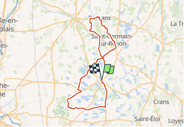
44 km | 49 km-effort
3h 19min
![](https://static1.geolcdn.com/siteimages/upload/files/16400158638029165_repeat_loop_refresh_sync_direction_icon.png)
Ja
![Tour Wandern Le Plantay - ABBAYE Notre-Dame-des-Dombes (18 km - D. 110 m) - Photo](https://media.geolcdn.com/t/375/260/e6fe5bea-e495-4660-8f1e-51eec1e720f3.jpg&format=jpg&maxdim=2)
![Wandern Wandern](https://static1.geolcdn.com/sitytour/trail-icons/101.png)
ABBAYE Notre-Dame-des-Dombes (18 km - D. 110 m)
Wandern
Einfach
Le Plantay,
Auvergne-Rhone-Alpen,
Ain,
France
![](/images/other/stat-length.png)
18,1 km | 19,6 km-effort
4h 43min
![](https://static1.geolcdn.com/siteimages/upload/files/16400158638029165_repeat_loop_refresh_sync_direction_icon.png)
Ja
![Tour Motor Villars-les-Dombes - sortie yves pauget 08/2024 - Photo](https://media.geolcdn.com/t/375/260/ext.jpg?maxdim=2&url=https%3A%2F%2Fstatic1.geolcdn.com%2Fsiteimages%2Fupload%2Ffiles%2F15247431544x4.jpg)
![Motor Motor](https://static1.geolcdn.com/sitytour/trail-icons/400.png)
sortie yves pauget 08/2024
Motor
Sehr leicht
Villars-les-Dombes,
Auvergne-Rhone-Alpen,
Ain,
France
![](/images/other/stat-length.png)
64 km | 72 km-effort
Unbekannt
![](https://static1.geolcdn.com/siteimages/upload/files/16400158638029165_repeat_loop_refresh_sync_direction_icon.png)
Ja
![Tour Wandern Bouligneux - Bouligneux-Etang de la petite Bozonnière-Ain - Photo](https://media.geolcdn.com/t/375/260/ext.jpg?maxdim=2&url=https%3A%2F%2Fstatic1.geolcdn.com%2Fsiteimages%2Fupload%2Ffiles%2F1553511878bg_sport_marche.png)
![Wandern Wandern](https://static1.geolcdn.com/sitytour/trail-icons/101.png)
Bouligneux-Etang de la petite Bozonnière-Ain
Wandern
Medium
Bouligneux,
Auvergne-Rhone-Alpen,
Ain,
France
![](/images/other/stat-length.png)
7 km | 7,6 km-effort
1h 43min
![](https://static1.geolcdn.com/siteimages/upload/files/16400158638029165_repeat_loop_refresh_sync_direction_icon.png)
Ja
![Tour Fahrrad Villars-les-Dombes - ain en velo circuit 19 - Photo](https://media.geolcdn.com/t/375/260/ext.jpg?maxdim=2&url=https%3A%2F%2Fstatic1.geolcdn.com%2Fsiteimages%2Fupload%2Ffiles%2F1524743154velo.jpg)
![Fahrrad Fahrrad](https://static1.geolcdn.com/sitytour/trail-icons/200.png)
ain en velo circuit 19
Fahrrad
Sehr leicht
Villars-les-Dombes,
Auvergne-Rhone-Alpen,
Ain,
France
![](/images/other/stat-length.png)
43 km | 48 km-effort
2h 46min
![](https://static1.geolcdn.com/siteimages/upload/files/16400158638029165_repeat_loop_refresh_sync_direction_icon.png)
Ja
![Tour Fahrrad Villars-les-Dombes - ain en velo circuit 19 - Photo](https://media.geolcdn.com/t/375/260/ext.jpg?maxdim=2&url=https%3A%2F%2Fstatic1.geolcdn.com%2Fsiteimages%2Fupload%2Ffiles%2F1524743154velo.jpg)
![Fahrrad Fahrrad](https://static1.geolcdn.com/sitytour/trail-icons/200.png)
ain en velo circuit 19
Fahrrad
Sehr leicht
Villars-les-Dombes,
Auvergne-Rhone-Alpen,
Ain,
France
![](/images/other/stat-length.png)
43 km | 48 km-effort
Unbekannt
![](https://static1.geolcdn.com/siteimages/upload/files/16400158638029165_repeat_loop_refresh_sync_direction_icon.png)
Ja
![Tour Wandern Bouligneux - Les étangs de Bouligneux - Photo](https://media.geolcdn.com/t/375/260/ext.jpg?maxdim=2&url=https%3A%2F%2Fstatic1.geolcdn.com%2Fsiteimages%2Fupload%2Ffiles%2F1553511878bg_sport_marche.png)
![Wandern Wandern](https://static1.geolcdn.com/sitytour/trail-icons/101.png)
Les étangs de Bouligneux
Wandern
Einfach
(3)
Bouligneux,
Auvergne-Rhone-Alpen,
Ain,
France
![](/images/other/stat-length.png)
7,2 km | 7,8 km-effort
4h 0min
![](https://static1.geolcdn.com/siteimages/upload/files/16400158638029165_repeat_loop_refresh_sync_direction_icon.png)
Ja
![Tour sport Villars-les-Dombes - 2025-02-07_17h25m09_LYONETREGION_VELO_06_VoyageVelo_Dombes - Photo](https://media.geolcdn.com/t/375/260/ext.jpg?maxdim=2&url=https%3A%2F%2Fsecurestorage.geolives.com%2Fsitytour%2Ftrail-bg%2Fdefault.jpg)
2025-02-07_17h25m09_LYONETREGION_VELO_06_VoyageVelo_Dombes
sport
Sehr leicht
Villars-les-Dombes,
Auvergne-Rhone-Alpen,
Ain,
France
![](/images/other/stat-length.png)
157 km | 175 km-effort
Unbekannt
![](https://static1.geolcdn.com/siteimages/upload/files/16400158638029165_repeat_loop_refresh_sync_direction_icon.png)
Nein
![Tour sport Villars-les-Dombes - Parc oiseaux Villars - Photo](https://media.geolcdn.com/t/375/260/ext.jpg?maxdim=2&url=https%3A%2F%2Fsecurestorage.geolives.com%2Fsitytour%2Ftrail-bg%2Fdefault.jpg)
Parc oiseaux Villars
sport
Sehr leicht
Villars-les-Dombes,
Auvergne-Rhone-Alpen,
Ain,
France
![](/images/other/stat-length.png)
3,9 km | 4,1 km-effort
Unbekannt
![](https://static1.geolcdn.com/siteimages/upload/files/16400158638029165_repeat_loop_refresh_sync_direction_icon.png)
Ja