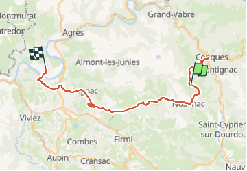
![](/images/other/stat-length.png)
![Tour Wandern Conques-en-Rouergue - J6_Conques - Livinhac-le-Haut - Photo](https://media.geolcdn.com/t/1900/400/ext.pjpeg?maxdim=2&url=https%3A%2F%2Fstatic1.geolcdn.com%2Fsiteimages%2Fupload%2Ffiles%2F1553511878bg_sport_marche.png)
J6_Conques - Livinhac-le-Haut
MAD-CVW
Benutzer
![Länge](/images/other/stat-length.png)
![Maximale Höhe](https://static1.geolcdn.com/siteimages/upload/files/1508320355ic_sort_altitude_max_24dp.png)
![Positive Höhendifferenz](https://static1.geolcdn.com/siteimages/upload/files/1508320355ic_sort_den_pos_24dp.png)
![Km-Effort](/images/other/stat-length.png)
![Min. Höhe](https://static1.geolcdn.com/siteimages/upload/files/1508320355ic_sort_altitude_min_24dp.png)
![Negative Höhendifferenz](https://static1.geolcdn.com/siteimages/upload/files/1508320355ic_sort_den_neg_24dp.png)
![Boucle](https://static1.geolcdn.com/siteimages/upload/files/16400158638029165_repeat_loop_refresh_sync_direction_icon.png)
![Wandern](https://static1.geolcdn.com/sitytour/trail-icons/101.png)
9h08
Schwierigkeit : Sehr schwierig
![Scannen Sie diesen QR-Code, um die Tour in der SityTrail-Anwendung zu öffnen](https://capi.geolives.com/qq0zvz2zws4bq2lad0pu/sitytour/trails/4009123/qr.png?size=200)
Kostenlosegpshiking-Anwendung
Über SityTrail
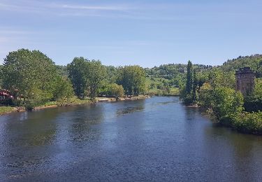
Tour Wandern von 29 km verfügbar auf Okzitanien, Aveyron, Conques-en-Rouergue. Diese Tour wird von MAD-CVW vorgeschlagen.
Beschreibung
Au départ du bas du Village de Conques, traverser la route et le pont pour monter en face vers la chapelle Ste-Foy. Le chemin part par le GR65 (une option possible par GR6) a travers forêt.
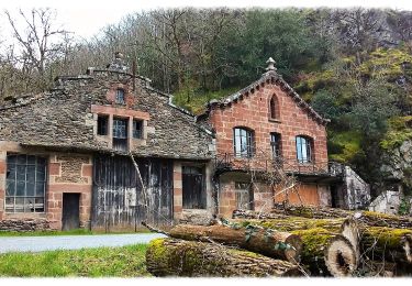
Avant Decazeville, au niveau de St-Michel, éviter de descendre en ville et continuer par chemin à droite non balisé, autour de la prairie, pour descendre au ruisseau, passage à gué et remonter le chemin forestier en face. Très beau parcours en forêt, passage devant belle statue de St-Vincent pour aboutir à Agnac. De là, prendre à gauche en direction de la route des crêtes qui mène à St-Roch pour rejoindre le GR65. Poursuivre jusqu'à Livinhac.
Ort
Kommentare
Touren in der Umgebung
![Tour Wandern Conques-en-Rouergue - Noailhac - Livinhac le Haut - Chemin de St-Jacques de Compostelle - Photo](https://media.geolcdn.com/t/375/260/ext.jpg?maxdim=2&url=https%3A%2F%2Fservices.sitytrail.com%2FGeolivesWS%2FDownloadMedia.ashx%3FTrailID%3D108747%26Media%3D1842_2.jpg)
![Wandern Wandern](https://static1.geolcdn.com/sitytour/trail-icons/101.png)
Wandern
![](/images/other/stat-length.png)
![](https://static1.geolcdn.com/siteimages/upload/files/16400158638029165_repeat_loop_refresh_sync_direction_icon.png)
![Tour Zu Fuß Conques-en-Rouergue - TerraTrail 7 - Photo](https://media.geolcdn.com/t/375/260/a3c72d09-9e84-4bb5-99d1-f393f2772e29.jpeg&format=jpg&maxdim=2)
![Zu Fuß Zu Fuß](https://static1.geolcdn.com/sitytour/trail-icons/100.png)
Zu Fuß
![](/images/other/stat-length.png)
![](https://static1.geolcdn.com/siteimages/upload/files/16400158638029165_repeat_loop_refresh_sync_direction_icon.png)
![Tour Zu Fuß Conques-en-Rouergue - Terra Trail 4 - Photo](https://media.geolcdn.com/t/375/260/582e6a36-dda7-4261-bff8-366b356e65bd.jpeg&format=jpg&maxdim=2)
![Zu Fuß Zu Fuß](https://static1.geolcdn.com/sitytour/trail-icons/100.png)
Zu Fuß
![](/images/other/stat-length.png)
![](https://static1.geolcdn.com/siteimages/upload/files/16400158638029165_repeat_loop_refresh_sync_direction_icon.png)
![Tour Zu Fuß Conques-en-Rouergue - Terra Trail 13 - Photo](https://media.geolcdn.com/t/375/260/6ade8042-762e-4e35-9e01-06c65cc37682.jpeg&format=jpg&maxdim=2)
![Zu Fuß Zu Fuß](https://static1.geolcdn.com/sitytour/trail-icons/100.png)
Zu Fuß
![](/images/other/stat-length.png)
![](https://static1.geolcdn.com/siteimages/upload/files/16400158638029165_repeat_loop_refresh_sync_direction_icon.png)
![Tour Wandern Conques-en-Rouergue - Conques Levinhac le Haut Avril 2018 - Photo](https://media.geolcdn.com/t/375/260/ext.jpg?maxdim=2&url=https%3A%2F%2Fservices.sitytrail.com%2FGeolivesWS%2FDownloadMedia.ashx%3FTrailID%3D954999%26Media%3Dfix__20180426142306.jpg)
![Wandern Wandern](https://static1.geolcdn.com/sitytour/trail-icons/101.png)
Wandern
![](/images/other/stat-length.png)
![](https://static1.geolcdn.com/siteimages/upload/files/16400158638029165_repeat_loop_refresh_sync_direction_icon.png)
![Tour Wandern Conques-en-Rouergue - Conques - Photo](https://media.geolcdn.com/t/375/260/b1ba52c1-bc17-4a66-9751-be2d2d70e0b7.jpg&format=jpg&maxdim=2)
![Wandern Wandern](https://static1.geolcdn.com/sitytour/trail-icons/101.png)
Wandern
![](/images/other/stat-length.png)
![](https://static1.geolcdn.com/siteimages/upload/files/16400158638029165_repeat_loop_refresh_sync_direction_icon.png)
![Tour Zu Fuß Conques-en-Rouergue - Le Chemin de l'Oiseau - Photo](https://media.geolcdn.com/t/375/260/f752b5f6-aabc-453a-a878-cae2a59e13be.jpeg&format=jpg&maxdim=2)
![Zu Fuß Zu Fuß](https://static1.geolcdn.com/sitytour/trail-icons/100.png)
Zu Fuß
![](/images/other/stat-length.png)
![](https://static1.geolcdn.com/siteimages/upload/files/16400158638029165_repeat_loop_refresh_sync_direction_icon.png)
![Tour Zu Fuß Conques-en-Rouergue - Sentier Conques - Grand-Vabre - Photo](https://media.geolcdn.com/t/375/260/54393b8a-3c65-496a-ad24-69e3b20f1258.jpeg&format=jpg&maxdim=2)
![Zu Fuß Zu Fuß](https://static1.geolcdn.com/sitytour/trail-icons/100.png)
Zu Fuß
![](/images/other/stat-length.png)
![](https://static1.geolcdn.com/siteimages/upload/files/16400158638029165_repeat_loop_refresh_sync_direction_icon.png)
![Tour Zu Fuß Conques-en-Rouergue - Le Sentier de Saint-Roch - Photo](https://media.geolcdn.com/t/375/260/8bcc1917-1226-4e60-ad74-d1ab4018c3dd.jpeg&format=jpg&maxdim=2)
![Zu Fuß Zu Fuß](https://static1.geolcdn.com/sitytour/trail-icons/100.png)
Zu Fuß
![](/images/other/stat-length.png)
![](https://static1.geolcdn.com/siteimages/upload/files/16400158638029165_repeat_loop_refresh_sync_direction_icon.png)