![](/images/other/stat-length.png)
![Tour Wandern Chaumont-en-Vexin - Chaumont en Vexin - Eglise de Liancourt Saint Pierre - Photo](https://media.geolcdn.com/t/1900/400/ext.pjpeg?maxdim=2&url=https%3A%2F%2Fstatic1.geolcdn.com%2Fsiteimages%2Fupload%2Ffiles%2F1553511878bg_sport_marche.png)
Chaumont en Vexin - Eglise de Liancourt Saint Pierre
marcel.F
Benutzer
![Länge](/images/other/stat-length.png)
Länge
12,4 km
![Maximale Höhe](https://static1.geolcdn.com/siteimages/upload/files/1508320355ic_sort_altitude_max_24dp.png)
Maximale Höhe
125 m
![Positive Höhendifferenz](https://static1.geolcdn.com/siteimages/upload/files/1508320355ic_sort_den_pos_24dp.png)
Positive Höhendifferenz
205 m
![Km-Effort](/images/other/stat-length.png)
Km-Effort
15,2 km
![Min. Höhe](https://static1.geolcdn.com/siteimages/upload/files/1508320355ic_sort_altitude_min_24dp.png)
Min. Höhe
63 m
![Negative Höhendifferenz](https://static1.geolcdn.com/siteimages/upload/files/1508320355ic_sort_den_neg_24dp.png)
Negative Höhendifferenz
205 m
![Boucle](https://static1.geolcdn.com/siteimages/upload/files/16400158638029165_repeat_loop_refresh_sync_direction_icon.png)
Boucle
Ja
Erstellungsdatum :
2019-04-01 20:24:47.7
Letzte Änderung :
2019-04-17 19:24:38.33
![Wandern](https://static1.geolcdn.com/sitytour/trail-icons/101.png)
3h18
Schwierigkeit : Einfach
![Scannen Sie diesen QR-Code, um die Tour in der SityTrail-Anwendung zu öffnen](https://capi.geolives.com/qq0zvz2zws4bq2lad0pu/sitytour/trails/399960/qr.png?size=200)
Kostenlosegpshiking-Anwendung
Über SityTrail
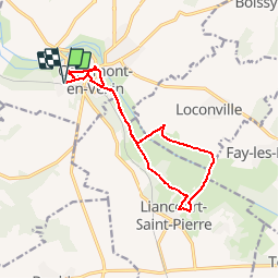
Tour Wandern von 12,4 km verfügbar auf Nordfrankreich, Oise, Chaumont-en-Vexin. Diese Tour wird von marcel.F vorgeschlagen.
Beschreibung
Départ de la gare de Chaumont en Vexin
puis rue du château, puis sente jusqu'à la Mairie, puis rue du Moulin Baudet, puis chemin jusqu'à Liancourt St Pierre, tour du village puis retour vers Chaumont, monter à l'église et parking de la gare
Ort
Land:
France
Region :
Nordfrankreich
Abteilung/Provinz :
Oise
Kommune :
Chaumont-en-Vexin
Standort:
Unknown
Gehen Sie:(Dec)
Gehen Sie:(UTM)
417986 ; 5457145 (31U) N.
Kommentare
Touren in der Umgebung
![Tour Wandern Delincourt - Delincourt, Le Mesnil, Reilly, La vierge, Delincourt - Photo](https://media.geolcdn.com/t/375/260/e0951489-e018-4b39-a4ca-54d29c362145.jpg&format=jpg&maxdim=2)
![Wandern Wandern](https://static1.geolcdn.com/sitytour/trail-icons/101.png)
Delincourt, Le Mesnil, Reilly, La vierge, Delincourt
Wandern
Medium
(1)
Delincourt,
Nordfrankreich,
Oise,
France
![](/images/other/stat-length.png)
8,7 km | 10,4 km-effort
2h 16min
![](https://static1.geolcdn.com/siteimages/upload/files/16400158638029165_repeat_loop_refresh_sync_direction_icon.png)
Ja
![Tour Wandern Chambors - CHAMBORS - Lattainville-Delincourt-Reillly - Photo](https://media.geolcdn.com/t/375/260/ext.jpg?maxdim=2&url=https%3A%2F%2Fstatic1.geolcdn.com%2Fsiteimages%2Fupload%2Ffiles%2F1553511878bg_sport_marche.png)
![Wandern Wandern](https://static1.geolcdn.com/sitytour/trail-icons/101.png)
CHAMBORS - Lattainville-Delincourt-Reillly
Wandern
Sehr leicht
(1)
Chambors,
Nordfrankreich,
Oise,
France
![](/images/other/stat-length.png)
12,3 km | 15,2 km-effort
2h 54min
![](https://static1.geolcdn.com/siteimages/upload/files/16400158638029165_repeat_loop_refresh_sync_direction_icon.png)
Ja
![Tour Nordic Walking Chambors - Marche Nordique 61 Chambors - Photo](https://media.geolcdn.com/t/375/260/ext.jpg?maxdim=2&url=https%3A%2F%2Fstatic1.geolcdn.com%2Fsiteimages%2Fupload%2Ffiles%2F1545311037marcheuse_200dpi.jpg)
![Nordic Walking Nordic Walking](https://static1.geolcdn.com/sitytour/trail-icons/102.png)
Marche Nordique 61 Chambors
Nordic Walking
Einfach
(1)
Chambors,
Nordfrankreich,
Oise,
France
![](/images/other/stat-length.png)
8,4 km | 10,3 km-effort
1h 30min
![](https://static1.geolcdn.com/siteimages/upload/files/16400158638029165_repeat_loop_refresh_sync_direction_icon.png)
Ja
![Tour Wandern Trie-Château - Trie Château - La vallée de l'Aunette - Photo](https://media.geolcdn.com/t/375/260/ext.jpg?maxdim=2&url=https%3A%2F%2Fstatic1.geolcdn.com%2Fsiteimages%2Fupload%2Ffiles%2F1553511878bg_sport_marche.png)
![Wandern Wandern](https://static1.geolcdn.com/sitytour/trail-icons/101.png)
Trie Château - La vallée de l'Aunette
Wandern
Schwierig
(1)
Trie-Château,
Nordfrankreich,
Oise,
France
![](/images/other/stat-length.png)
11,8 km | 13,7 km-effort
3h 0min
![](https://static1.geolcdn.com/siteimages/upload/files/16400158638029165_repeat_loop_refresh_sync_direction_icon.png)
Ja
![Tour Wandern Chambors - Chambors - le dolmen 12 - Photo](https://media.geolcdn.com/t/375/260/ext.jpg?maxdim=2&url=https%3A%2F%2Fstatic1.geolcdn.com%2Fsiteimages%2Fupload%2Ffiles%2F1553511878bg_sport_marche.png)
![Wandern Wandern](https://static1.geolcdn.com/sitytour/trail-icons/101.png)
Chambors - le dolmen 12
Wandern
Einfach
(1)
Chambors,
Nordfrankreich,
Oise,
France
![](/images/other/stat-length.png)
12,4 km | 16 km-effort
3h 31min
![](https://static1.geolcdn.com/siteimages/upload/files/16400158638029165_repeat_loop_refresh_sync_direction_icon.png)
Ja
![Tour Wandern Chambors - Chambors - le dolmen 9 - Photo](https://media.geolcdn.com/t/375/260/ext.jpg?maxdim=2&url=https%3A%2F%2Fstatic1.geolcdn.com%2Fsiteimages%2Fupload%2Ffiles%2F1553511878bg_sport_marche.png)
![Wandern Wandern](https://static1.geolcdn.com/sitytour/trail-icons/101.png)
Chambors - le dolmen 9
Wandern
Einfach
(4)
Chambors,
Nordfrankreich,
Oise,
France
![](/images/other/stat-length.png)
9,3 km | 12,1 km-effort
2h 38min
![](https://static1.geolcdn.com/siteimages/upload/files/16400158638029165_repeat_loop_refresh_sync_direction_icon.png)
Ja
![Tour Wandern Trie-Château - groux tri-chateau - Photo](https://media.geolcdn.com/t/375/260/6d1804ac-71d7-4fb4-b972-aff9d4811a7f.jpg&format=jpg&maxdim=2)
![Wandern Wandern](https://static1.geolcdn.com/sitytour/trail-icons/101.png)
groux tri-chateau
Wandern
Medium
Trie-Château,
Nordfrankreich,
Oise,
France
![](/images/other/stat-length.png)
9,2 km | 11 km-effort
2h 0min
![](https://static1.geolcdn.com/siteimages/upload/files/16400158638029165_repeat_loop_refresh_sync_direction_icon.png)
Ja
![Tour Wandern Chambors - Randonnée des 4 villages de Chambors à Lattainville, Delincourt et Reilly - Photo](https://media.geolcdn.com/t/375/260/8849e884-8973-4940-9f52-03e50cfc47e7.jpg&format=jpg&maxdim=2)
![Wandern Wandern](https://static1.geolcdn.com/sitytour/trail-icons/101.png)
Randonnée des 4 villages de Chambors à Lattainville, Delincourt et Reilly
Wandern
Schwierig
Chambors,
Nordfrankreich,
Oise,
France
![](/images/other/stat-length.png)
11,9 km | 14,7 km-effort
2h 46min
![](https://static1.geolcdn.com/siteimages/upload/files/16400158638029165_repeat_loop_refresh_sync_direction_icon.png)
Ja
![Tour Zu Fuß Chambors - Chambors - Lattainville - Delincourt - Reilly - Photo](https://media.geolcdn.com/t/375/260/ext.jpg?maxdim=2&url=https%3A%2F%2Fstatic1.geolcdn.com%2Fsiteimages%2Fupload%2Ffiles%2F1545311037marcheuse_200dpi.jpg)
![Zu Fuß Zu Fuß](https://static1.geolcdn.com/sitytour/trail-icons/100.png)
Chambors - Lattainville - Delincourt - Reilly
Zu Fuß
Medium
(1)
Chambors,
Nordfrankreich,
Oise,
France
![](/images/other/stat-length.png)
12,2 km | 15,1 km-effort
4h 0min
![](https://static1.geolcdn.com/siteimages/upload/files/16400158638029165_repeat_loop_refresh_sync_direction_icon.png)
Ja