![](/images/other/stat-length.png)
![Tour Wandern Irun - Ibarla - Cascade d'Aitzondo - Ermitage san Martzial 2024 01 21 - Photo](https://media.geolcdn.com/t/1900/400/ext.pjpeg?maxdim=2&url=https%3A%2F%2Fservices.sitytrail.com%2FGeolivesWS%2FDownloadMedia.ashx%3FTrailID%3D530456%26Media%3Dfix__20160226111436.jpg)
Ibarla - Cascade d'Aitzondo - Ermitage san Martzial 2024 01 21
DECHAMPD
Benutzer
![Länge](/images/other/stat-length.png)
![Maximale Höhe](https://static1.geolcdn.com/siteimages/upload/files/1508320355ic_sort_altitude_max_24dp.png)
![Positive Höhendifferenz](https://static1.geolcdn.com/siteimages/upload/files/1508320355ic_sort_den_pos_24dp.png)
![Km-Effort](/images/other/stat-length.png)
![Min. Höhe](https://static1.geolcdn.com/siteimages/upload/files/1508320355ic_sort_altitude_min_24dp.png)
![Negative Höhendifferenz](https://static1.geolcdn.com/siteimages/upload/files/1508320355ic_sort_den_neg_24dp.png)
![Boucle](https://static1.geolcdn.com/siteimages/upload/files/16400158638029165_repeat_loop_refresh_sync_direction_icon.png)
![Wandern](https://static1.geolcdn.com/sitytour/trail-icons/101.png)
4h28
Schwierigkeit : Sehr schwierig
![Scannen Sie diesen QR-Code, um die Tour in der SityTrail-Anwendung zu öffnen](https://capi.geolives.com/qq0zvz2zws4bq2lad0pu/sitytour/trails/3996828/qr.png?size=200)
Kostenlosegpshiking-Anwendung
Über SityTrail
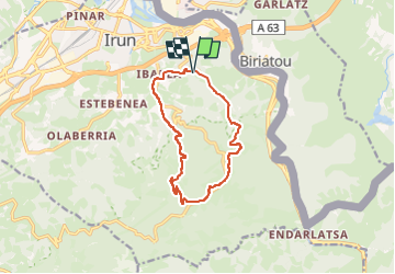
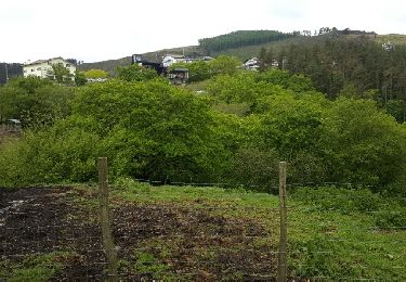
Tour Wandern von 12,1 km verfügbar auf Autonome Gemeinschaft Baskenland, Gipuzkoa, Irun. Diese Tour wird von DECHAMPD vorgeschlagen.
Beschreibung
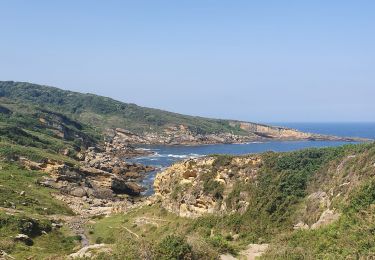
Nous marcherons en direction du sud. Nous passerons devant une pisciculture pour monter en direction du mont Enbido.
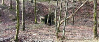
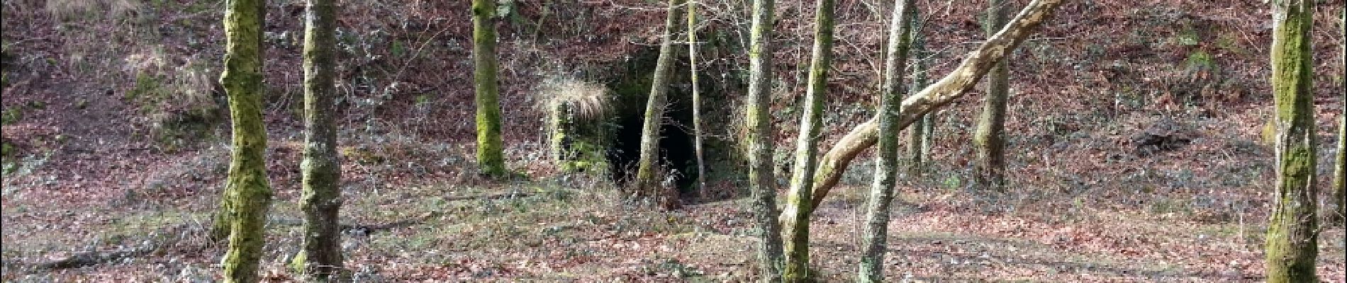
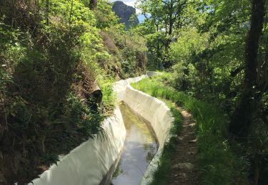
Nous passerons devant la cascade d'Aitzondo. Prévoir quelques lampes, il y aura une succession de petits tunnels.
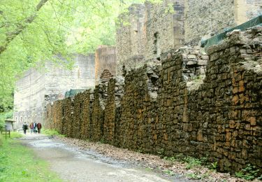
Nous monterons au fort d'Erlatz pour descendre ensuite à l'Ermitage de San Martial.
L'ermitage de St Martial fait partie du superbe paysage du mont Albade, connu à Irun sous le nom de San Martzial.
Le monument fut construit pour commémorer la victoire des habitants d'Irun sur les troupes françaises lors de la bataille du 30 juin 1522.
Nous nous dirigerons ensuite vers le départ pour terminer cette rando
Départ : Parking JATEXEA entrée d'Ibarla.
Prendre ensuite la 1ère route à droite à l’entrée d'Ibarla juste après être passés sous le pont de l'autoroute.
POIs
Ort
Kommentare
Touren in der Umgebung
![Tour Wandern Biriatou - Biriatou et lac Poiriers - Photo](https://media.geolcdn.com/t/375/260/ext.jpg?maxdim=2&url=https%3A%2F%2Fservices.sitytrail.com%2FGeolivesWS%2FDownloadMedia.ashx%3FTrailID%3D444455%26Media%3D20150712102756.jpg)
![Wandern Wandern](https://static1.geolcdn.com/sitytour/trail-icons/101.png)
Wandern
![](/images/other/stat-length.png)
![](https://static1.geolcdn.com/siteimages/upload/files/16400158638029165_repeat_loop_refresh_sync_direction_icon.png)
![Tour Wandern Irun - cascade dEnbido- Aitzondo mines et ravin de Meazuri 2024/11/12 - Photo](https://media.geolcdn.com/t/375/260/ea942abe-41d1-4bc7-b9a0-e2b821ade3bf.jpeg&format=jpg&maxdim=2)
![Wandern Wandern](https://static1.geolcdn.com/sitytour/trail-icons/101.png)
Wandern
![](/images/other/stat-length.png)
![](https://static1.geolcdn.com/siteimages/upload/files/16400158638029165_repeat_loop_refresh_sync_direction_icon.png)
![Tour Zu Fuß Irun - SL-GI 1006 Cascada de Aitzondo - Photo](https://media.geolcdn.com/t/375/260/949c10e2-10b5-4598-a875-2bd7cf386c52.jpeg&format=jpg&maxdim=2)
![Zu Fuß Zu Fuß](https://static1.geolcdn.com/sitytour/trail-icons/100.png)
Zu Fuß
![](/images/other/stat-length.png)
![](https://static1.geolcdn.com/siteimages/upload/files/16400158638029165_repeat_loop_refresh_sync_direction_icon.png)
![Tour Wandern Hondarribia/Fontarrabie - hondarribia cap figuier - Photo](https://media.geolcdn.com/t/375/260/ace45812-18e3-4fc6-bc81-bbde70a3189c.jpg&format=jpg&maxdim=2)
![Wandern Wandern](https://static1.geolcdn.com/sitytour/trail-icons/101.png)
Wandern
![](/images/other/stat-length.png)
![](https://static1.geolcdn.com/siteimages/upload/files/16400158638029165_repeat_loop_refresh_sync_direction_icon.png)
![Tour Wandern Biriatou - biriatou chemin de la foret - Photo](https://media.geolcdn.com/t/375/260/88e58450-9581-446b-a93b-1872d9ed62c8.jpg&format=jpg&maxdim=2)
![Wandern Wandern](https://static1.geolcdn.com/sitytour/trail-icons/101.png)
Wandern
![](/images/other/stat-length.png)
![](https://static1.geolcdn.com/siteimages/upload/files/16400158638029165_repeat_loop_refresh_sync_direction_icon.png)
![Tour Wandern Irun - Ibarla - Cascade d'Aitzondo - Ermitage san Martzial 2020 01 21 - Photo](https://media.geolcdn.com/t/375/260/ext.jpg?maxdim=2&url=https%3A%2F%2Fservices.sitytrail.com%2FGeolivesWS%2FDownloadMedia.ashx%3FTrailID%3D530456%26Media%3Dfix__20160226111436.jpg)
![Wandern Wandern](https://static1.geolcdn.com/sitytour/trail-icons/101.png)
Wandern
![](/images/other/stat-length.png)
![](https://static1.geolcdn.com/siteimages/upload/files/16400158638029165_repeat_loop_refresh_sync_direction_icon.png)
![Tour Wandern Hendaye - Hendaye Saint Sébastien GR121 Sentier du littoral - Photo](https://media.geolcdn.com/t/375/260/cc4c2380-6e4a-4daa-be29-494539f023ee.jpg&format=jpg&maxdim=2)
![Wandern Wandern](https://static1.geolcdn.com/sitytour/trail-icons/101.png)
Wandern
![](/images/other/stat-length.png)
![](https://static1.geolcdn.com/siteimages/upload/files/16400158638029165_repeat_loop_refresh_sync_direction_icon.png)
![Tour Wandern Irun - Boucle 3 couronnes - Photo](https://media.geolcdn.com/t/375/260/41c00aa6-38bd-42a4-af79-2355a90b16df.jpg&format=jpg&maxdim=2)
![Wandern Wandern](https://static1.geolcdn.com/sitytour/trail-icons/101.png)
Wandern
![](/images/other/stat-length.png)
![](https://static1.geolcdn.com/siteimages/upload/files/16400158638029165_repeat_loop_refresh_sync_direction_icon.png)
![Tour Andere Aktivitäten Hendaye - TDP N°1 HENDAYE OLHETTE - Photo](https://media.geolcdn.com/t/375/260/ext.jpg?maxdim=2&url=https%3A%2F%2Fservices.sitytrail.com%2FGeolivesWS%2FDownloadMedia.ashx%3FTrailID%3D746598%26Media%3Dfix__20170503112435.jpg)
![Andere Aktivitäten Andere Aktivitäten](https://static1.geolcdn.com/sitytour/trail-icons/900.png)
Andere Aktivitäten
![](/images/other/stat-length.png)
![](https://static1.geolcdn.com/siteimages/upload/files/16400158638029165_repeat_loop_refresh_sync_direction_icon.png)