![](/images/other/stat-length.png)
![Tour Wandern Bièvre - 15 km Marche Adeps Naomé 7 avril - Photo](https://media.geolcdn.com/t/1900/400/ext.pjpeg?maxdim=2&url=https%3A%2F%2Fmedia.geolcdn.com%2Ff%2Fab883f55-06d4-4613-878e-b20e7ead35ec.jpg)
15 km Marche Adeps Naomé 7 avril
Tourisme5555
Benutzer
![Länge](/images/other/stat-length.png)
Länge
15,1 km
![Maximale Höhe](https://static1.geolcdn.com/siteimages/upload/files/1508320355ic_sort_altitude_max_24dp.png)
Maximale Höhe
432 m
![Positive Höhendifferenz](https://static1.geolcdn.com/siteimages/upload/files/1508320355ic_sort_den_pos_24dp.png)
Positive Höhendifferenz
304 m
![Km-Effort](/images/other/stat-length.png)
Km-Effort
19,1 km
![Min. Höhe](https://static1.geolcdn.com/siteimages/upload/files/1508320355ic_sort_altitude_min_24dp.png)
Min. Höhe
336 m
![Negative Höhendifferenz](https://static1.geolcdn.com/siteimages/upload/files/1508320355ic_sort_den_neg_24dp.png)
Negative Höhendifferenz
305 m
![Boucle](https://static1.geolcdn.com/siteimages/upload/files/16400158638029165_repeat_loop_refresh_sync_direction_icon.png)
Boucle
Ja
Erstellungsdatum :
2024-03-22 08:26:02.016
Letzte Änderung :
2024-04-06 10:54:47.05
![Wandern](https://static1.geolcdn.com/sitytour/trail-icons/101.png)
4h20
Schwierigkeit : Medium
![Scannen Sie diesen QR-Code, um die Tour in der SityTrail-Anwendung zu öffnen](https://capi.geolives.com/qq0zvz2zws4bq2lad0pu/sitytour/trails/3989512/qr.png?size=200)
Kostenlosegpshiking-Anwendung
Über SityTrail
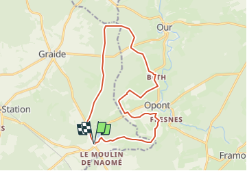
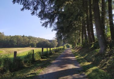
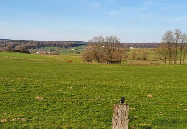
Tour Wandern von 15,1 km verfügbar auf Wallonien, Namur, Bièvre. Diese Tour wird von Tourisme5555 vorgeschlagen.
Beschreibung
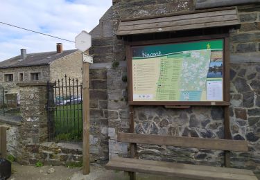
15 km de randonnée sur les pas des Seigneurs à Naomé.
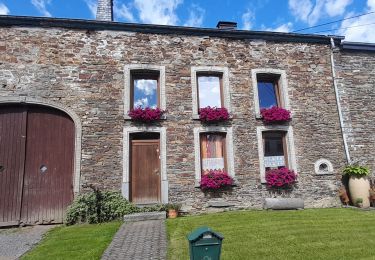
Le village de Naomé a possédé plusieurs noms. Retenons le premier ALDEMEGA (770-779) qui signifie "la manse de l'homme libre" (manse : maison familiale d'une terre agricole au Moyen Age).
Ort
Land:
Belgium
Region :
Wallonien
Abteilung/Provinz :
Namur
Kommune :
Bièvre
Standort:
Unknown
Gehen Sie:(Dec)
Gehen Sie:(UTM)
649949 ; 5532062 (31U) N.
Kommentare
Touren in der Umgebung
![Tour Wandern Paliseul - Balade au pays de la Haute-Lesse - Au fil de l'Our - Photo](https://media.geolcdn.com/t/375/260/ext.jpg?maxdim=2&url=https%3A%2F%2Fservices.sitytrail.com%2FGeolivesWS%2FDownloadMedia.ashx%3FTrailID%3D449048%26Media%3Db3ac4524-5d5c-4ded-ad9c-c2811f9c6857.JPG)
![Wandern Wandern](https://static1.geolcdn.com/sitytour/trail-icons/101.png)
Balade au pays de la Haute-Lesse - Au fil de l'Our
Wandern
Einfach
(6)
Paliseul,
Wallonien,
Luxemburg,
Belgium
![](/images/other/stat-length.png)
11,5 km | 14,5 km-effort
3h 9min
![](https://static1.geolcdn.com/siteimages/upload/files/16400158638029165_repeat_loop_refresh_sync_direction_icon.png)
Ja
![Tour Zu Fuß Bièvre - Marie Reine - Photo](https://media.geolcdn.com/t/375/260/ext.jpg?maxdim=2&url=https%3A%2F%2Fpivotmedia.tourismewallonie.be%2FOTH-A0-005T-0Q2M%2FOTH-A0-005T-0Q2M.jpg)
![Zu Fuß Zu Fuß](https://static1.geolcdn.com/sitytour/trail-icons/100.png)
![Tour Zu Fuß Bièvre - Les Translets - Photo](https://media.geolcdn.com/t/375/260/ext.jpg?maxdim=2&url=https%3A%2F%2Fpivotmedia.tourismewallonie.be%2FOTH-A0-005O-0MHC%2FOTH-A0-005O-0MHC.jpg)
![Zu Fuß Zu Fuß](https://static1.geolcdn.com/sitytour/trail-icons/100.png)
Les Translets
Zu Fuß
Einfach
(2)
Bièvre,
Wallonien,
Namur,
Belgium
![](/images/other/stat-length.png)
6,8 km | 8,6 km-effort
1h 56min
![](https://static1.geolcdn.com/siteimages/upload/files/16400158638029165_repeat_loop_refresh_sync_direction_icon.png)
Ja
![Tour Mountainbike Paliseul - Carlsbourg : circuit VTT bleu - Photo](https://media.geolcdn.com/t/375/260/ext.jpg?maxdim=2&url=https%3A%2F%2Fpivotmedia.tourismewallonie.be%2FOTH-A0-005M-33B0%2FOTH-A0-005M-33B0.jpg)
![Mountainbike Mountainbike](https://static1.geolcdn.com/sitytour/trail-icons/202.png)
Carlsbourg : circuit VTT bleu
Mountainbike
Einfach
Paliseul,
Wallonien,
Luxemburg,
Belgium
![](/images/other/stat-length.png)
10 km | 12,2 km-effort
50min
![](https://static1.geolcdn.com/siteimages/upload/files/16400158638029165_repeat_loop_refresh_sync_direction_icon.png)
Ja
![Tour Mountainbike Paliseul - Paliseul : circuit VTT jaune - Photo](https://media.geolcdn.com/t/375/260/ext.jpg?maxdim=2&url=https%3A%2F%2Fpivotmedia.tourismewallonie.be%2FOTH-A0-005X-261N%2FOTH-A0-005X-261N.jpg)
![Mountainbike Mountainbike](https://static1.geolcdn.com/sitytour/trail-icons/202.png)
Paliseul : circuit VTT jaune
Mountainbike
Medium
Paliseul,
Wallonien,
Luxemburg,
Belgium
![](/images/other/stat-length.png)
20 km | 26 km-effort
1h 46min
![](https://static1.geolcdn.com/siteimages/upload/files/16400158638029165_repeat_loop_refresh_sync_direction_icon.png)
Ja
![Tour Zu Fuß Paliseul - Paliseul : Paul Verlaine - Photo](https://media.geolcdn.com/t/375/260/ext.jpg?maxdim=2&url=https%3A%2F%2Fpivotmedia.tourismewallonie.be%2FOTH-A0-005W-1MS9%2FOTH-A0-005W-1MS9.jpg)
![Zu Fuß Zu Fuß](https://static1.geolcdn.com/sitytour/trail-icons/100.png)
Paliseul : Paul Verlaine
Zu Fuß
Einfach
(2)
Paliseul,
Wallonien,
Luxemburg,
Belgium
![](/images/other/stat-length.png)
5,9 km | 7,1 km-effort
1h 37min
![](https://static1.geolcdn.com/siteimages/upload/files/16400158638029165_repeat_loop_refresh_sync_direction_icon.png)
Ja
![Tour Zu Fuß Paliseul - Paliseul : De Périgé - Photo](https://media.geolcdn.com/t/375/260/ext.jpg?maxdim=2&url=https%3A%2F%2Fpivotmedia.tourismewallonie.be%2FOTH-A0-005X-156V%2FOTH-A0-005X-156V.jpg)
![Zu Fuß Zu Fuß](https://static1.geolcdn.com/sitytour/trail-icons/100.png)
Paliseul : De Périgé
Zu Fuß
Einfach
(2)
Paliseul,
Wallonien,
Luxemburg,
Belgium
![](/images/other/stat-length.png)
9,4 km | 11,8 km-effort
2h 40min
![](https://static1.geolcdn.com/siteimages/upload/files/16400158638029165_repeat_loop_refresh_sync_direction_icon.png)
Ja
![Tour Zu Fuß Paliseul - Carlsbourg : De l'Almache - Photo](https://media.geolcdn.com/t/375/260/ext.jpg?maxdim=2&url=https%3A%2F%2Fpivotmedia.tourismewallonie.be%2FOTH-A0-005M-37G9%2FOTH-A0-005M-37G9.jpg)
![Zu Fuß Zu Fuß](https://static1.geolcdn.com/sitytour/trail-icons/100.png)
Carlsbourg : De l'Almache
Zu Fuß
Einfach
Paliseul,
Wallonien,
Luxemburg,
Belgium
![](/images/other/stat-length.png)
6,4 km | 7,8 km-effort
1h 46min
![](https://static1.geolcdn.com/siteimages/upload/files/16400158638029165_repeat_loop_refresh_sync_direction_icon.png)
Ja
![Tour Zu Fuß Paliseul - Carlsbourg : Du bois du Defoy - Photo](https://media.geolcdn.com/t/375/260/ext.jpg?maxdim=2&url=https%3A%2F%2Fpivotmedia.tourismewallonie.be%2FOTH-A0-005M-36Q6%2FOTH-A0-005M-36Q6.jpg)
![Zu Fuß Zu Fuß](https://static1.geolcdn.com/sitytour/trail-icons/100.png)
Carlsbourg : Du bois du Defoy
Zu Fuß
Einfach
Paliseul,
Wallonien,
Luxemburg,
Belgium
![](/images/other/stat-length.png)
7,9 km | 9,6 km-effort
2h 10min
![](https://static1.geolcdn.com/siteimages/upload/files/16400158638029165_repeat_loop_refresh_sync_direction_icon.png)
Ja