![](/images/other/stat-length.png)
![Tour Wandern Barbières - Traversée Barbières Beauregard-Baret - Photo](https://media.geolcdn.com/t/1900/400/2a3121e4-a036-4b19-8247-21a832e98ad8.jpg&format=pjpeg&maxdim=2)
Traversée Barbières Beauregard-Baret
GuyVachet
Benutzer
![Länge](/images/other/stat-length.png)
Länge
17 km
![Maximale Höhe](https://static1.geolcdn.com/siteimages/upload/files/1508320355ic_sort_altitude_max_24dp.png)
Maximale Höhe
879 m
![Positive Höhendifferenz](https://static1.geolcdn.com/siteimages/upload/files/1508320355ic_sort_den_pos_24dp.png)
Positive Höhendifferenz
826 m
![Km-Effort](/images/other/stat-length.png)
Km-Effort
28 km
![Min. Höhe](https://static1.geolcdn.com/siteimages/upload/files/1508320355ic_sort_altitude_min_24dp.png)
Min. Höhe
421 m
![Negative Höhendifferenz](https://static1.geolcdn.com/siteimages/upload/files/1508320355ic_sort_den_neg_24dp.png)
Negative Höhendifferenz
837 m
![Boucle](https://static1.geolcdn.com/siteimages/upload/files/16400158638029165_repeat_loop_refresh_sync_direction_icon.png)
Boucle
Nein
Erstellungsdatum :
2024-03-21 08:04:00.073
Letzte Änderung :
2024-03-22 07:28:37.102
![Wandern](https://static1.geolcdn.com/sitytour/trail-icons/101.png)
7h09
Schwierigkeit : Sehr schwierig
![Scannen Sie diesen QR-Code, um die Tour in der SityTrail-Anwendung zu öffnen](https://capi.geolives.com/qq0zvz2zws4bq2lad0pu/sitytour/trails/3989159/qr.png?size=200)
Kostenlosegpshiking-Anwendung
Über SityTrail
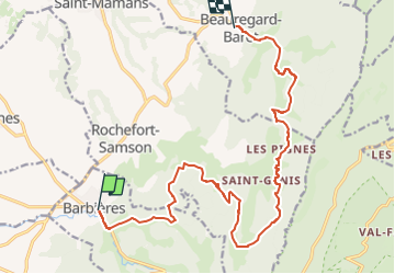
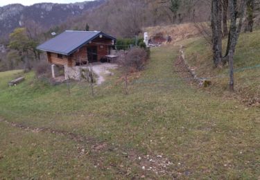
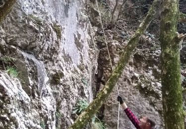
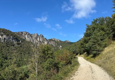
Tour Wandern von 17 km verfügbar auf Auvergne-Rhone-Alpen, Drôme, Barbières. Diese Tour wird von GuyVachet vorgeschlagen.
Beschreibung
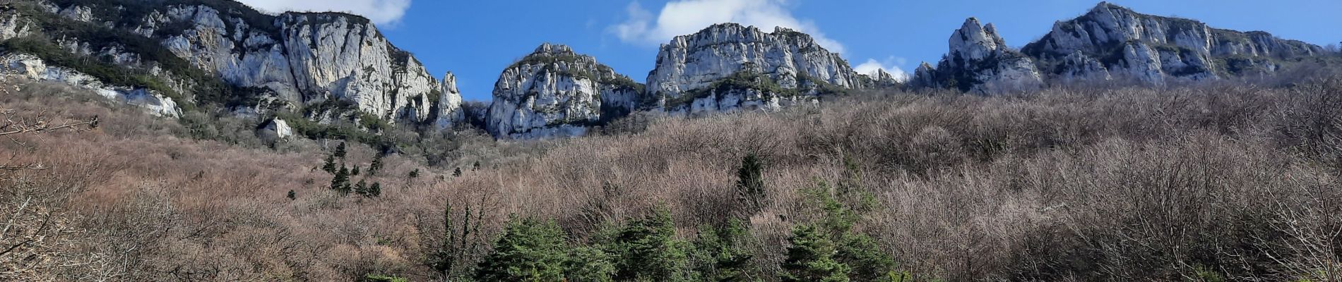
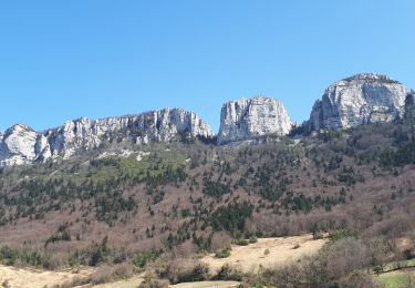
Traversée au pied des Monts du Matin. Ces premiers contreforts du Vercors marquant l'entrée dans les Alpes depuis la Vallée du Rhône.
Ort
Land:
France
Region :
Auvergne-Rhone-Alpen
Abteilung/Provinz :
Drôme
Kommune :
Barbières
Standort:
Unknown
Gehen Sie:(Dec)
Gehen Sie:(UTM)
668931 ; 4980288 (31T) N.
Kommentare
Touren in der Umgebung
![Tour Wandern Beauregard-Baret - Pré de Cinq Sous - Beauregard Baret - Photo](https://media.geolcdn.com/t/375/260/ext.jpg?maxdim=2&url=https%3A%2F%2Fservices.sitytrail.com%2FGeolivesWS%2FDownloadMedia.ashx%3FTrailID%3D214828%26Media%3D15342_3.jpg)
![Wandern Wandern](https://static1.geolcdn.com/sitytour/trail-icons/101.png)
Pré de Cinq Sous - Beauregard Baret
Wandern
Medium
(1)
Beauregard-Baret,
Auvergne-Rhone-Alpen,
Drôme,
France
![](/images/other/stat-length.png)
11,6 km | 23 km-effort
5h 0min
![](https://static1.geolcdn.com/siteimages/upload/files/16400158638029165_repeat_loop_refresh_sync_direction_icon.png)
Ja
![Tour Wandern Rochefort-Samson - Les Vachères - Combe d'oyans - Photo](https://media.geolcdn.com/t/375/260/b496d0d5-f9c5-4087-8105-422c092be197.jpg&format=jpg&maxdim=2)
![Wandern Wandern](https://static1.geolcdn.com/sitytour/trail-icons/101.png)
Les Vachères - Combe d'oyans
Wandern
Schwierig
(1)
Rochefort-Samson,
Auvergne-Rhone-Alpen,
Drôme,
France
![](/images/other/stat-length.png)
17,1 km | 28 km-effort
8h 26min
![](https://static1.geolcdn.com/siteimages/upload/files/16400158638029165_repeat_loop_refresh_sync_direction_icon.png)
Ja
![Tour Wandern Saint-Vincent-la-Commanderie - Pierre Chauve 1308m, les Roches de Treillaras, depuis les Condamines - Photo](https://media.geolcdn.com/t/375/260/ext.jpg?maxdim=2&url=https%3A%2F%2Fservices.sitytrail.com%2FGeolivesWS%2FDownloadMedia.ashx%3FTrailID%3D318111%26Media%3D17572_1.jpg)
![Wandern Wandern](https://static1.geolcdn.com/sitytour/trail-icons/101.png)
Pierre Chauve 1308m, les Roches de Treillaras, depuis les Condamines
Wandern
Medium
(2)
Saint-Vincent-la-Commanderie,
Auvergne-Rhone-Alpen,
Drôme,
France
![](/images/other/stat-length.png)
12,7 km | 25 km-effort
6h 30min
![](https://static1.geolcdn.com/siteimages/upload/files/16400158638029165_repeat_loop_refresh_sync_direction_icon.png)
Ja
![Tour Wandern Beauregard-Baret - reco cx st Gervais b baret - Photo](https://media.geolcdn.com/t/375/260/62f4b6af-f36d-4d7e-9bf7-cff82879ff65.jpg&format=jpg&maxdim=2)
![Wandern Wandern](https://static1.geolcdn.com/sitytour/trail-icons/101.png)
reco cx st Gervais b baret
Wandern
Schwierig
Beauregard-Baret,
Auvergne-Rhone-Alpen,
Drôme,
France
![](/images/other/stat-length.png)
9,4 km | 16,2 km-effort
4h 58min
![](https://static1.geolcdn.com/siteimages/upload/files/16400158638029165_repeat_loop_refresh_sync_direction_icon.png)
Nein
![Tour Wandern Saint-Vincent-la-Commanderie - 26 st Vincent commanderie zel - Photo](https://media.geolcdn.com/t/375/260/64d0078a-2be9-41db-957b-395e9e3d9a48.jpg&format=jpg&maxdim=2)
![Wandern Wandern](https://static1.geolcdn.com/sitytour/trail-icons/101.png)
26 st Vincent commanderie zel
Wandern
Einfach
Saint-Vincent-la-Commanderie,
Auvergne-Rhone-Alpen,
Drôme,
France
![](/images/other/stat-length.png)
14,2 km | 22 km-effort
6h 5min
![](https://static1.geolcdn.com/siteimages/upload/files/16400158638029165_repeat_loop_refresh_sync_direction_icon.png)
Ja
![Tour Wandern Beauregard-Baret - croix st Gervais et Pas du loup - Photo](https://media.geolcdn.com/t/375/260/31db5131-e481-415d-9c06-0a841965de22.jpg&format=jpg&maxdim=2)
![Wandern Wandern](https://static1.geolcdn.com/sitytour/trail-icons/101.png)
croix st Gervais et Pas du loup
Wandern
Medium
Beauregard-Baret,
Auvergne-Rhone-Alpen,
Drôme,
France
![](/images/other/stat-length.png)
10 km | 16,9 km-effort
5h 4min
![](https://static1.geolcdn.com/siteimages/upload/files/16400158638029165_repeat_loop_refresh_sync_direction_icon.png)
Nein
![Tour Wandern Léoncel - Pierre Chauve depuis le Col de Tourniol - Photo](https://media.geolcdn.com/t/375/260/ext.jpg?maxdim=2&url=https%3A%2F%2Fstatic1.geolcdn.com%2Fsiteimages%2Fupload%2Ffiles%2F1553511878bg_sport_marche.png)
![Wandern Wandern](https://static1.geolcdn.com/sitytour/trail-icons/101.png)
Pierre Chauve depuis le Col de Tourniol
Wandern
Einfach
(3)
Léoncel,
Auvergne-Rhone-Alpen,
Drôme,
France
![](/images/other/stat-length.png)
7,9 km | 12,3 km-effort
2h 52min
![](https://static1.geolcdn.com/siteimages/upload/files/16400158638029165_repeat_loop_refresh_sync_direction_icon.png)
Ja
![Tour Wandern Barbières - 26 pierre chauve barbieres zel - Photo](https://media.geolcdn.com/t/375/260/92caf138-cce3-4645-835e-f3491e5ff577.jpg&format=jpg&maxdim=2)
![Wandern Wandern](https://static1.geolcdn.com/sitytour/trail-icons/101.png)
26 pierre chauve barbieres zel
Wandern
Medium
Barbières,
Auvergne-Rhone-Alpen,
Drôme,
France
![](/images/other/stat-length.png)
13,8 km | 26 km-effort
7h 9min
![](https://static1.geolcdn.com/siteimages/upload/files/16400158638029165_repeat_loop_refresh_sync_direction_icon.png)
Nein
![Tour sport Beauregard-Baret - Pierre rousse pas de pourceau l’eau basse - Photo](https://media.geolcdn.com/t/375/260/8f7985a7-111f-4318-9d67-55ef317841a8.jpg&format=jpg&maxdim=2)
Pierre rousse pas de pourceau l’eau basse
sport
Sehr leicht
Beauregard-Baret,
Auvergne-Rhone-Alpen,
Drôme,
France
![](/images/other/stat-length.png)
14,7 km | 28 km-effort
Unbekannt
![](https://static1.geolcdn.com/siteimages/upload/files/16400158638029165_repeat_loop_refresh_sync_direction_icon.png)
Ja