![](/images/other/stat-length.png)
![Tour Zu Fuß Baume-les-Dames - Baume les Dames Doubs par les cretes - Photo](https://media.geolcdn.com/t/1900/400/ext.pjpeg?maxdim=2&url=https%3A%2F%2Fstatic1.geolcdn.com%2Fsiteimages%2Fupload%2Ffiles%2F1545311037marcheuse_200dpi.jpg)
Baume les Dames Doubs par les cretes
gerard70
Benutzer
![Länge](/images/other/stat-length.png)
Länge
23 km
![Maximale Höhe](https://static1.geolcdn.com/siteimages/upload/files/1508320355ic_sort_altitude_max_24dp.png)
Maximale Höhe
562 m
![Positive Höhendifferenz](https://static1.geolcdn.com/siteimages/upload/files/1508320355ic_sort_den_pos_24dp.png)
Positive Höhendifferenz
924 m
![Km-Effort](/images/other/stat-length.png)
Km-Effort
35 km
![Min. Höhe](https://static1.geolcdn.com/siteimages/upload/files/1508320355ic_sort_altitude_min_24dp.png)
Min. Höhe
263 m
![Negative Höhendifferenz](https://static1.geolcdn.com/siteimages/upload/files/1508320355ic_sort_den_neg_24dp.png)
Negative Höhendifferenz
921 m
![Boucle](https://static1.geolcdn.com/siteimages/upload/files/16400158638029165_repeat_loop_refresh_sync_direction_icon.png)
Boucle
Ja
Erstellungsdatum :
2024-03-16 15:30:54.943
Letzte Änderung :
2024-03-16 15:45:52.259
![Zu Fuß](https://static1.geolcdn.com/sitytour/trail-icons/100.png)
7h59
Schwierigkeit : Schwierig
![Scannen Sie diesen QR-Code, um die Tour in der SityTrail-Anwendung zu öffnen](https://capi.geolives.com/qq0zvz2zws4bq2lad0pu/sitytour/trails/3982918/qr.png?size=200)
Kostenlosegpshiking-Anwendung
Über SityTrail
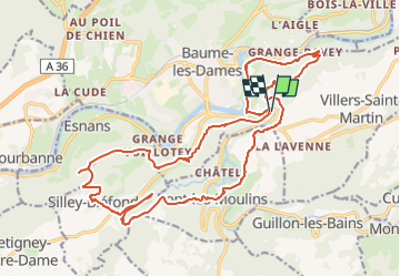
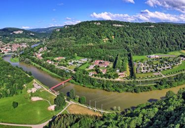
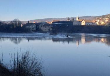
Tour Zu Fuß von 23 km verfügbar auf Burgund und Freigrafschaft, Doubs, Baume-les-Dames. Diese Tour wird von gerard70 vorgeschlagen.
Beschreibung
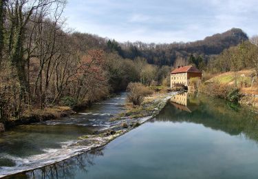
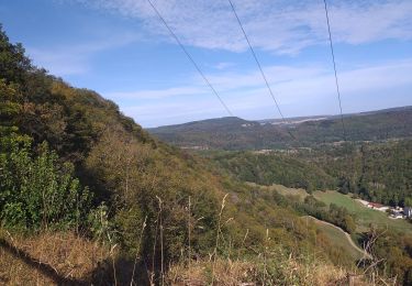
Randonné difficile sol glissant à éviter par temps de pluie,6km d enrobé sur le parcours impossible de l'éviter ,superbe point de vue sur la vallée du doubs
Ort
Land:
France
Region :
Burgund und Freigrafschaft
Abteilung/Provinz :
Doubs
Kommune :
Baume-les-Dames
Standort:
Unknown
Gehen Sie:(Dec)
Gehen Sie:(UTM)
302171 ; 5246494 (32T) N.
Kommentare
Touren in der Umgebung
![Tour Wandern Villers-Saint-Martin - Villers st Martin](https://media.geolcdn.com/t/375/260/2c6ae54c-f240-47b2-a0d6-247007965cef.jpg&format=jpg&maxdim=2)
![Wandern Wandern](https://static1.geolcdn.com/sitytour/trail-icons/101.png)
Villers st Martin "la combe au louvier"
Wandern
Medium
(1)
Villers-Saint-Martin,
Burgund und Freigrafschaft,
Doubs,
France
![](/images/other/stat-length.png)
11,5 km | 16,5 km-effort
7h 18min
![](https://static1.geolcdn.com/siteimages/upload/files/16400158638029165_repeat_loop_refresh_sync_direction_icon.png)
Ja
![Tour Andere Aktivitäten Cusance - Val de Cusance, source bleue - Photo](https://media.geolcdn.com/t/375/260/ext.jpg?maxdim=2&url=https%3A%2F%2Fstatic1.geolcdn.com%2Fsiteimages%2Fupload%2Ffiles%2F1545311037marcheuse_200dpi.jpg)
![Andere Aktivitäten Andere Aktivitäten](https://static1.geolcdn.com/sitytour/trail-icons/900.png)
Val de Cusance, source bleue
Andere Aktivitäten
Einfach
(2)
Cusance,
Burgund und Freigrafschaft,
Doubs,
France
![](/images/other/stat-length.png)
14,5 km | 21 km-effort
2h 14min
![](https://static1.geolcdn.com/siteimages/upload/files/16400158638029165_repeat_loop_refresh_sync_direction_icon.png)
Ja
![Tour Wandern Silley-Bléfond - Silley Blėfond - Photo](https://media.geolcdn.com/t/375/260/72cba853-944f-4e71-a6a4-e1015b10675c.jpg&format=jpg&maxdim=2)
![Wandern Wandern](https://static1.geolcdn.com/sitytour/trail-icons/101.png)
Silley Blėfond
Wandern
Medium
Silley-Bléfond,
Burgund und Freigrafschaft,
Doubs,
France
![](/images/other/stat-length.png)
15,8 km | 22 km-effort
3h 23min
![](https://static1.geolcdn.com/siteimages/upload/files/16400158638029165_repeat_loop_refresh_sync_direction_icon.png)
Ja
![Tour Zu Fuß Autechaux - Les Mondreveaux - Photo](https://media.geolcdn.com/t/375/260/9292facd-28bd-4ee3-8a8e-4b9d0684041b.jpeg&format=jpg&maxdim=2)
![Zu Fuß Zu Fuß](https://static1.geolcdn.com/sitytour/trail-icons/100.png)
Les Mondreveaux
Zu Fuß
Einfach
Autechaux,
Burgund und Freigrafschaft,
Doubs,
France
![](/images/other/stat-length.png)
10,5 km | 12,4 km-effort
2h 49min
![](https://static1.geolcdn.com/siteimages/upload/files/16400158638029165_repeat_loop_refresh_sync_direction_icon.png)
Ja
![Tour Zu Fuß Esnans - Mont Dommage - Photo](https://media.geolcdn.com/t/375/260/79f418a8-7ee1-46f5-8173-ee740f887b5c.jpeg&format=jpg&maxdim=2)
![Zu Fuß Zu Fuß](https://static1.geolcdn.com/sitytour/trail-icons/100.png)
Mont Dommage
Zu Fuß
Einfach
Esnans,
Burgund und Freigrafschaft,
Doubs,
France
![](/images/other/stat-length.png)
8,6 km | 13 km-effort
2h 57min
![](https://static1.geolcdn.com/siteimages/upload/files/16400158638029165_repeat_loop_refresh_sync_direction_icon.png)
Nein
![Tour Zu Fuß Baume-les-Dames - La Croix de Châtard - Photo](https://media.geolcdn.com/t/375/260/d651c9f5-c262-4fb0-99ee-1d55033f4dec.jpeg&format=jpg&maxdim=2)
![Zu Fuß Zu Fuß](https://static1.geolcdn.com/sitytour/trail-icons/100.png)
La Croix de Châtard
Zu Fuß
Einfach
Baume-les-Dames,
Burgund und Freigrafschaft,
Doubs,
France
![](/images/other/stat-length.png)
6,4 km | 9,1 km-effort
2h 3min
![](https://static1.geolcdn.com/siteimages/upload/files/16400158638029165_repeat_loop_refresh_sync_direction_icon.png)
Ja
![Tour Zu Fuß Baume-les-Dames - La Fente de Babre - Photo](https://media.geolcdn.com/t/375/260/f4606131-7993-4602-bc5e-c9844fe9a64f.jpeg&format=jpg&maxdim=2)
![Zu Fuß Zu Fuß](https://static1.geolcdn.com/sitytour/trail-icons/100.png)
La Fente de Babre
Zu Fuß
Einfach
Baume-les-Dames,
Burgund und Freigrafschaft,
Doubs,
France
![](/images/other/stat-length.png)
7,7 km | 11,4 km-effort
2h 35min
![](https://static1.geolcdn.com/siteimages/upload/files/16400158638029165_repeat_loop_refresh_sync_direction_icon.png)
Ja
![Tour Wandern Pont-les-Moulins - pont les moulins - Photo](https://media.geolcdn.com/t/375/260/7e6122b6-1654-426d-8833-6b2b329e62b0.jpg&format=jpg&maxdim=2)
![Wandern Wandern](https://static1.geolcdn.com/sitytour/trail-icons/101.png)
pont les moulins
Wandern
Einfach
(1)
Pont-les-Moulins,
Burgund und Freigrafschaft,
Doubs,
France
![](/images/other/stat-length.png)
16,8 km | 23 km-effort
2h 49min
![](https://static1.geolcdn.com/siteimages/upload/files/16400158638029165_repeat_loop_refresh_sync_direction_icon.png)
Ja
![Tour Wandern Baume-les-Dames - Baume les dames, fente de Babre - Photo](https://media.geolcdn.com/t/375/260/aa0af467-9313-4a29-a7b9-19f30e0259cd.jpg&format=jpg&maxdim=2)
![Wandern Wandern](https://static1.geolcdn.com/sitytour/trail-icons/101.png)
Baume les dames, fente de Babre
Wandern
Einfach
Baume-les-Dames,
Burgund und Freigrafschaft,
Doubs,
France
![](/images/other/stat-length.png)
10,4 km | 14,7 km-effort
1h 39min
![](https://static1.geolcdn.com/siteimages/upload/files/16400158638029165_repeat_loop_refresh_sync_direction_icon.png)
Ja