![](/images/other/stat-length.png)
![Tour Wandern Septmoncel les Molunes - sentier des chamois - Photo](https://media.geolcdn.com/t/1900/400/ext.pjpeg?maxdim=2&url=https%3A%2F%2Fstatic1.geolcdn.com%2Fsiteimages%2Fupload%2Ffiles%2F1553511878bg_sport_marche.png)
sentier des chamois
cron
Benutzer
![Länge](/images/other/stat-length.png)
Länge
16,5 km
![Maximale Höhe](https://static1.geolcdn.com/siteimages/upload/files/1508320355ic_sort_altitude_max_24dp.png)
Maximale Höhe
1212 m
![Positive Höhendifferenz](https://static1.geolcdn.com/siteimages/upload/files/1508320355ic_sort_den_pos_24dp.png)
Positive Höhendifferenz
1033 m
![Km-Effort](/images/other/stat-length.png)
Km-Effort
30 km
![Min. Höhe](https://static1.geolcdn.com/siteimages/upload/files/1508320355ic_sort_altitude_min_24dp.png)
Min. Höhe
451 m
![Negative Höhendifferenz](https://static1.geolcdn.com/siteimages/upload/files/1508320355ic_sort_den_neg_24dp.png)
Negative Höhendifferenz
1031 m
![Boucle](https://static1.geolcdn.com/siteimages/upload/files/16400158638029165_repeat_loop_refresh_sync_direction_icon.png)
Boucle
Ja
Erstellungsdatum :
2024-03-06 10:15:14.582
Letzte Änderung :
2024-03-06 10:17:43.767
![Wandern](https://static1.geolcdn.com/sitytour/trail-icons/101.png)
6h52
Schwierigkeit : Sehr schwierig
![Scannen Sie diesen QR-Code, um die Tour in der SityTrail-Anwendung zu öffnen](https://capi.geolives.com/qq0zvz2zws4bq2lad0pu/sitytour/trails/3971709/qr.png?size=200)
Kostenlosegpshiking-Anwendung
Über SityTrail
Tour Wandern von 16,5 km verfügbar auf Burgund und Freigrafschaft, Jura, Septmoncel les Molunes. Diese Tour wird von cron vorgeschlagen.
Beschreibung
Départ : de la place du village de Septmoncel prendre la direction du Plateau multisports Le Replan. Suivre la route sur 800 m jusqu'au terrain de football.
Ort
Land:
France
Region :
Burgund und Freigrafschaft
Abteilung/Provinz :
Jura
Kommune :
Septmoncel les Molunes
Standort:
Unknown
Gehen Sie:(Dec)
Gehen Sie:(UTM)
723405 ; 5139233 (31T) N.
Kommentare
Touren in der Umgebung
![Tour Wandern Septmoncel les Molunes - circuit des chamois Septmoncel - Photo](https://media.geolcdn.com/t/375/260/ext.jpg?maxdim=2&url=https%3A%2F%2Fservices.sitytrail.com%2FGeolivesWS%2FDownloadMedia.ashx%3FTrailID%3D799248%26Media%3D20170730174922.jpg)
![Wandern Wandern](https://static1.geolcdn.com/sitytour/trail-icons/101.png)
circuit des chamois Septmoncel
Wandern
Schwierig
(1)
Septmoncel les Molunes,
Burgund und Freigrafschaft,
Jura,
France
![](/images/other/stat-length.png)
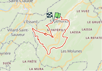
16,3 km | 31 km-effort
5h 51min
![](https://static1.geolcdn.com/siteimages/upload/files/16400158638029165_repeat_loop_refresh_sync_direction_icon.png)
Ja
![Tour Wandern Lamoura - Tresberruy - Lamoura - Photo](https://media.geolcdn.com/t/375/260/ext.jpg?maxdim=2&url=https%3A%2F%2Fservices.sitytrail.com%2FGeolivesWS%2FDownloadMedia.ashx%3FTrailID%3D191503%26Media%3D15097_5.jpg)
![Wandern Wandern](https://static1.geolcdn.com/sitytour/trail-icons/101.png)
Tresberruy - Lamoura
Wandern
Schwierig
(1)
Lamoura,
Burgund und Freigrafschaft,
Jura,
France
![](/images/other/stat-length.png)
14,5 km | 20 km-effort
4h 0min
![](https://static1.geolcdn.com/siteimages/upload/files/16400158638029165_repeat_loop_refresh_sync_direction_icon.png)
Ja
![Tour Wandern Septmoncel les Molunes - mo sentier des lapidaires - Photo](https://media.geolcdn.com/t/375/260/3ce9e642-8b27-4197-a9db-76cbf671243e.jpg&format=jpg&maxdim=2)
![Wandern Wandern](https://static1.geolcdn.com/sitytour/trail-icons/101.png)
mo sentier des lapidaires
Wandern
Medium
Septmoncel les Molunes,
Burgund und Freigrafschaft,
Jura,
France
![](/images/other/stat-length.png)
10,3 km | 14,4 km-effort
3h 28min
![](https://static1.geolcdn.com/siteimages/upload/files/16400158638029165_repeat_loop_refresh_sync_direction_icon.png)
Ja
![Tour Laufen Saint-Claude - UTTJ 2015-1 - Photo](https://media.geolcdn.com/t/375/260/ext.jpg?maxdim=2&url=https%3A%2F%2Fstatic1.geolcdn.com%2Fsiteimages%2Fupload%2Ffiles%2F1524743154running.jpg)
![Laufen Laufen](https://static1.geolcdn.com/sitytour/trail-icons/103.png)
UTTJ 2015-1
Laufen
Sehr schwierig
(1)
Saint-Claude,
Burgund und Freigrafschaft,
Jura,
France
![](/images/other/stat-length.png)
56 km | 100 km-effort
20h 4min
![](https://static1.geolcdn.com/siteimages/upload/files/16400158638029165_repeat_loop_refresh_sync_direction_icon.png)
Nein
![Tour Wandern Villard-Saint-Sauveur - cascade de flumen - saut du chien - retour en partie par la route - Photo](https://media.geolcdn.com/t/375/260/677bfeb9-5daf-421e-aba3-7eb72ae37d4d.jpg&format=jpg&maxdim=2)
![Wandern Wandern](https://static1.geolcdn.com/sitytour/trail-icons/101.png)
cascade de flumen - saut du chien - retour en partie par la route
Wandern
Medium
Villard-Saint-Sauveur,
Burgund und Freigrafschaft,
Jura,
France
![](/images/other/stat-length.png)
9,4 km | 14,4 km-effort
3h 3min
![](https://static1.geolcdn.com/siteimages/upload/files/16400158638029165_repeat_loop_refresh_sync_direction_icon.png)
Ja
![Tour Wandern Septmoncel les Molunes - Les Molunes - mairie - Photo](https://media.geolcdn.com/t/375/260/ext.jpg?maxdim=2&url=https%3A%2F%2Fstatic1.geolcdn.com%2Fsiteimages%2Fupload%2Ffiles%2F1553511878bg_sport_marche.png)
![Wandern Wandern](https://static1.geolcdn.com/sitytour/trail-icons/101.png)
Les Molunes - mairie
Wandern
Medium
(1)
Septmoncel les Molunes,
Burgund und Freigrafschaft,
Jura,
France
![](/images/other/stat-length.png)
6,3 km | 8,4 km-effort
1h 54min
![](https://static1.geolcdn.com/siteimages/upload/files/16400158638029165_repeat_loop_refresh_sync_direction_icon.png)
Ja
![Tour Wandern Villard-Saint-Sauveur - Pont de l'Isle - cascade queue de cheval - Photo](https://media.geolcdn.com/t/375/260/3189b139-82f8-4327-afd3-bc3510f0244f.jpg&format=jpg&maxdim=2)
![Wandern Wandern](https://static1.geolcdn.com/sitytour/trail-icons/101.png)
Pont de l'Isle - cascade queue de cheval
Wandern
Einfach
Villard-Saint-Sauveur,
Burgund und Freigrafschaft,
Jura,
France
![](/images/other/stat-length.png)
7,6 km | 12,5 km-effort
2h 10min
![](https://static1.geolcdn.com/siteimages/upload/files/16400158638029165_repeat_loop_refresh_sync_direction_icon.png)
Ja
![Tour Wandern Saint-Claude - Belvd. Pontoux depuis Rue des Perrieres à St-Claude 39200 - Photo](https://media.geolcdn.com/t/375/260/f9b19760-1bb3-48d6-b56c-4ed1797baa03.jpg&format=jpg&maxdim=2)
![Wandern Wandern](https://static1.geolcdn.com/sitytour/trail-icons/101.png)
Belvd. Pontoux depuis Rue des Perrieres à St-Claude 39200
Wandern
Medium
Saint-Claude,
Burgund und Freigrafschaft,
Jura,
France
![](/images/other/stat-length.png)
14 km | 21 km-effort
3h 30min
![](https://static1.geolcdn.com/siteimages/upload/files/16400158638029165_repeat_loop_refresh_sync_direction_icon.png)
Ja
![Tour Wandern Lamoura - Autour Lamoura - Photo](https://media.geolcdn.com/t/375/260/4d2d444f-1c9a-4eba-b912-3979cf888d2a.jpg&format=jpg&maxdim=2)
![Wandern Wandern](https://static1.geolcdn.com/sitytour/trail-icons/101.png)
Autour Lamoura
Wandern
Medium
Lamoura,
Burgund und Freigrafschaft,
Jura,
France
![](/images/other/stat-length.png)
17,1 km | 25 km-effort
4h 37min
![](https://static1.geolcdn.com/siteimages/upload/files/16400158638029165_repeat_loop_refresh_sync_direction_icon.png)
Ja