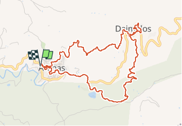
![](/images/other/stat-length.png)
![Tour Wandern Arenas - Arenas Iglesia Santa Catalina jusqu'à Daimalos Fuente del amor - Photo](https://media.geolcdn.com/t/1900/400/0d2df59d-b345-406c-b3e9-94d4f29617f4.jpg&format=pjpeg&maxdim=2)
Arenas Iglesia Santa Catalina jusqu'à Daimalos Fuente del amor
jpipacific
Benutzer
![Länge](/images/other/stat-length.png)
![Maximale Höhe](https://static1.geolcdn.com/siteimages/upload/files/1508320355ic_sort_altitude_max_24dp.png)
![Positive Höhendifferenz](https://static1.geolcdn.com/siteimages/upload/files/1508320355ic_sort_den_pos_24dp.png)
![Km-Effort](/images/other/stat-length.png)
![Min. Höhe](https://static1.geolcdn.com/siteimages/upload/files/1508320355ic_sort_altitude_min_24dp.png)
![Negative Höhendifferenz](https://static1.geolcdn.com/siteimages/upload/files/1508320355ic_sort_den_neg_24dp.png)
![Boucle](https://static1.geolcdn.com/siteimages/upload/files/16400158638029165_repeat_loop_refresh_sync_direction_icon.png)
![Wandern](https://static1.geolcdn.com/sitytour/trail-icons/101.png)
2h24
Schwierigkeit : Medium
![Scannen Sie diesen QR-Code, um die Tour in der SityTrail-Anwendung zu öffnen](https://capi.geolives.com/qq0zvz2zws4bq2lad0pu/sitytour/trails/3969750/qr.png?size=200)
Kostenlosegpshiking-Anwendung
Über SityTrail
Tour Wandern von 7,3 km verfügbar auf Andalusien, Málaga, Arenas. Diese Tour wird von jpipacific vorgeschlagen.
Beschreibung
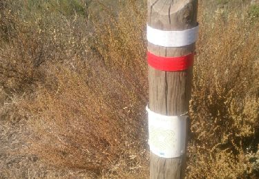
Cette rando se passe dans les plantations d'amandier et d'avocatier sur un versant à l'aller et sur l'autre au retour. Très facile à suivre dans sa première partie car il suffit de suivre les poteaux marqués vert et blanc. Ensuite il suffit de suivre le chemin parfois étroit jusqu'à la route.
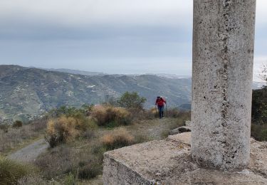
Ce n'est pas une randonnée très spectaculaire comme il en existe tant dans la région. Il n'y a jamais de grands et beaux point de vue.
De plus la traversée du village de Daimalos c'est faite dans une cacophonie d'aboiement de chien; insupportable.
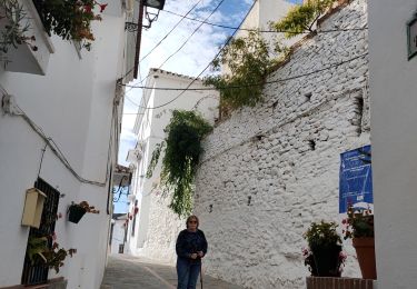
La visite de ARENAS est intéressante. C'est un joli village. Dommage que, là aussi, il y ait autant de chiens qui aboient.
Personnellement je ne reviendrai pas faire une randonnée à cet endroit.
Ort
Kommentare
Touren in der Umgebung
![Tour Wandern Sayalonga - Sayalonga Pico de la Rabita - Photo](https://media.geolcdn.com/t/375/260/6f11b6d2-45f7-4b69-9935-f3420b8de5af.jpg&format=jpg&maxdim=2)
![Wandern Wandern](https://static1.geolcdn.com/sitytour/trail-icons/101.png)
Wandern
![](/images/other/stat-length.png)
![](https://static1.geolcdn.com/siteimages/upload/files/16400158638029165_repeat_loop_refresh_sync_direction_icon.png)
![Tour Wandern Salares - De Salares au Cortijo Casa de Haro - Photo](https://media.geolcdn.com/t/375/260/0133e4ad-c9a5-4993-b166-70ad5d435e89.jpg&format=jpg&maxdim=2)
![Wandern Wandern](https://static1.geolcdn.com/sitytour/trail-icons/101.png)
Wandern
![](/images/other/stat-length.png)
![](https://static1.geolcdn.com/siteimages/upload/files/16400158638029165_repeat_loop_refresh_sync_direction_icon.png)
![Tour Andere Aktivitäten Canillas de Albaida - 14KM Canillas De Albeda - Photo](https://media.geolcdn.com/t/375/260/ext.jpg?maxdim=2&url=https%3A%2F%2Fstatic1.geolcdn.com%2Fsiteimages%2Fupload%2Ffiles%2F1545311037marcheuse_200dpi.jpg)
![Andere Aktivitäten Andere Aktivitäten](https://static1.geolcdn.com/sitytour/trail-icons/900.png)
Andere Aktivitäten
![](/images/other/stat-length.png)
![](https://static1.geolcdn.com/siteimages/upload/files/16400158638029165_repeat_loop_refresh_sync_direction_icon.png)
![Tour Andere Aktivitäten Salares - Canillas de Albeda - Photo](https://media.geolcdn.com/t/375/260/ext.jpg?maxdim=2&url=https%3A%2F%2Fservices.sitytrail.com%2FGeolivesWS%2FDownloadMedia.ashx%3FTrailID%3D841099%26Media%3Dfix__20171006134539.jpg)
![Andere Aktivitäten Andere Aktivitäten](https://static1.geolcdn.com/sitytour/trail-icons/900.png)
Andere Aktivitäten
![](/images/other/stat-length.png)
![](https://static1.geolcdn.com/siteimages/upload/files/16400158638029165_repeat_loop_refresh_sync_direction_icon.png)
![Tour Zu Fuß Salares - salares canillas almeida - Photo](https://media.geolcdn.com/t/375/260/ext.jpg?maxdim=2&url=https%3A%2F%2Fstatic1.geolcdn.com%2Fsiteimages%2Fupload%2Ffiles%2F1545311037marcheuse_200dpi.jpg)
![Zu Fuß Zu Fuß](https://static1.geolcdn.com/sitytour/trail-icons/100.png)
Zu Fuß
![](/images/other/stat-length.png)
![](https://static1.geolcdn.com/siteimages/upload/files/16400158638029165_repeat_loop_refresh_sync_direction_icon.png)