![](/images/other/stat-length.png)
![Tour Wandern La Cadière-d'Azur - la Cadière d'Azur 01-03-2024 - Photo](https://media.geolcdn.com/t/1900/400/e01b6a60-4b3b-4fb0-93c7-011648b90b15.jpg&format=pjpeg&maxdim=2)
la Cadière d'Azur 01-03-2024
Christiancordin
Benutzer
![Länge](/images/other/stat-length.png)
Länge
6,3 km
![Maximale Höhe](https://static1.geolcdn.com/siteimages/upload/files/1508320355ic_sort_altitude_max_24dp.png)
Maximale Höhe
226 m
![Positive Höhendifferenz](https://static1.geolcdn.com/siteimages/upload/files/1508320355ic_sort_den_pos_24dp.png)
Positive Höhendifferenz
154 m
![Km-Effort](/images/other/stat-length.png)
Km-Effort
8,3 km
![Min. Höhe](https://static1.geolcdn.com/siteimages/upload/files/1508320355ic_sort_altitude_min_24dp.png)
Min. Höhe
126 m
![Negative Höhendifferenz](https://static1.geolcdn.com/siteimages/upload/files/1508320355ic_sort_den_neg_24dp.png)
Negative Höhendifferenz
153 m
![Boucle](https://static1.geolcdn.com/siteimages/upload/files/16400158638029165_repeat_loop_refresh_sync_direction_icon.png)
Boucle
Ja
Erstellungsdatum :
2024-03-01 13:11:59.618
Letzte Änderung :
2024-03-05 12:54:53.864
![Wandern](https://static1.geolcdn.com/sitytour/trail-icons/101.png)
2h26
Schwierigkeit : Einfach
![Scannen Sie diesen QR-Code, um die Tour in der SityTrail-Anwendung zu öffnen](https://capi.geolives.com/qq0zvz2zws4bq2lad0pu/sitytour/trails/3966894/qr.png?size=200)
Kostenlosegpshiking-Anwendung
Über SityTrail
Tour Wandern von 6,3 km verfügbar auf Provence-Alpes-Côte d'Azur, Var, La Cadière-d'Azur. Diese Tour wird von Christiancordin vorgeschlagen.
Beschreibung
D PK du cimetière, église, table d'orientation, les hauteurs de la Cadière et ses points de vue, stade, St Marc, village de la Cadière d'Azur.
Ort
Land:
France
Region :
Provence-Alpes-Côte d'Azur
Abteilung/Provinz :
Var
Kommune :
La Cadière-d'Azur
Standort:
Unknown
Gehen Sie:(Dec)
Gehen Sie:(UTM)
724102 ; 4786377 (31T) N.
Kommentare
Touren in der Umgebung
![Tour Wandern Le Beausset - Trace_Quatre_Freres - Photo](https://media.geolcdn.com/t/375/260/a076bf67-1e95-4bda-8264-007e64206af1.jpg&format=jpg&maxdim=2)
![Wandern Wandern](https://static1.geolcdn.com/sitytour/trail-icons/101.png)
Trace_Quatre_Freres
Wandern
Sehr schwierig
(1)
Le Beausset,
Provence-Alpes-Côte d'Azur,
Var,
France
![](/images/other/stat-length.png)
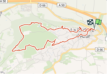
14,8 km | 19,6 km-effort
4h 26min
![](https://static1.geolcdn.com/siteimages/upload/files/16400158638029165_repeat_loop_refresh_sync_direction_icon.png)
Ja
![Tour Wandern Le Beausset - Tête du Cade par abime de Maramouyé - Photo](https://media.geolcdn.com/t/375/260/ext.jpg?maxdim=2&url=https%3A%2F%2Fservices.sitytrail.com%2FGeolivesWS%2FDownloadMedia.ashx%3FTrailID%3D1038187%26Media%3Dfix__20180911112303.jpg)
![Wandern Wandern](https://static1.geolcdn.com/sitytour/trail-icons/101.png)
Tête du Cade par abime de Maramouyé
Wandern
Sehr leicht
(1)
Le Beausset,
Provence-Alpes-Côte d'Azur,
Var,
France
![](/images/other/stat-length.png)
12,4 km | 16,1 km-effort
3h 36min
![](https://static1.geolcdn.com/siteimages/upload/files/16400158638029165_repeat_loop_refresh_sync_direction_icon.png)
Ja
![Tour Wandern Saint-Cyr-sur-Mer - St Cyr - Bandol - Photo](https://media.geolcdn.com/t/375/260/ext.jpg?maxdim=2&url=https%3A%2F%2Fservices.sitytrail.com%2FGeolivesWS%2FDownloadMedia.ashx%3FTrailID%3D746530%26Media%3Dfix__20170505150639.jpg)
![Wandern Wandern](https://static1.geolcdn.com/sitytour/trail-icons/101.png)
St Cyr - Bandol
Wandern
Medium
(1)
Saint-Cyr-sur-Mer,
Provence-Alpes-Côte d'Azur,
Var,
France
![](/images/other/stat-length.png)
16,1 km | 21 km-effort
4h 53min
![](https://static1.geolcdn.com/siteimages/upload/files/16400158638029165_repeat_loop_refresh_sync_direction_icon.png)
Nein
![Tour Nordic Walking La Cadière-d'Azur - 20220329_La Cadière d'Azur - Photo](https://media.geolcdn.com/t/375/260/ext.jpg?maxdim=2&url=https%3A%2F%2Fstatic1.geolcdn.com%2Fsiteimages%2Fupload%2Ffiles%2F1545311037marcheuse_200dpi.jpg)
![Nordic Walking Nordic Walking](https://static1.geolcdn.com/sitytour/trail-icons/102.png)
20220329_La Cadière d'Azur
Nordic Walking
Sehr leicht
(1)
La Cadière-d'Azur,
Provence-Alpes-Côte d'Azur,
Var,
France
![](/images/other/stat-length.png)
6,8 km | 8,6 km-effort
1h 30min
![](https://static1.geolcdn.com/siteimages/upload/files/16400158638029165_repeat_loop_refresh_sync_direction_icon.png)
Ja
![Tour Wandern Saint-Cyr-sur-Mer - le sentier littoral de la Madrague et la colline de sable - Photo](https://media.geolcdn.com/t/375/260/ext.jpg?maxdim=2&url=https%3A%2F%2Fservices.sitytrail.com%2FGeolivesWS%2FDownloadMedia.ashx%3FTrailID%3D485513%26Media%3D21ba94d9-fd64-486b-9460-9884fbc5235d.JPG)
![Wandern Wandern](https://static1.geolcdn.com/sitytour/trail-icons/101.png)
le sentier littoral de la Madrague et la colline de sable
Wandern
Einfach
(1)
Saint-Cyr-sur-Mer,
Provence-Alpes-Côte d'Azur,
Var,
France
![](/images/other/stat-length.png)
13 km | 18,7 km-effort
5h 20min
![](https://static1.geolcdn.com/siteimages/upload/files/16400158638029165_repeat_loop_refresh_sync_direction_icon.png)
Ja
![Tour Wandern Le Beausset - la tête de cade. Maison des 4 frères le Beausset - Photo](https://media.geolcdn.com/t/375/260/0d9e1f30-3a4b-476b-b15d-3d4d5c048e2b.jpg&format=jpg&maxdim=2)
![Wandern Wandern](https://static1.geolcdn.com/sitytour/trail-icons/101.png)
la tête de cade. Maison des 4 frères le Beausset
Wandern
Schwierig
Le Beausset,
Provence-Alpes-Côte d'Azur,
Var,
France
![](/images/other/stat-length.png)
9,7 km | 12,4 km-effort
3h 34min
![](https://static1.geolcdn.com/siteimages/upload/files/16400158638029165_repeat_loop_refresh_sync_direction_icon.png)
Nein
![Tour Wandern La Cadière-d'Azur - LA CADIERE - Photo](https://media.geolcdn.com/t/375/260/a2408c77-3028-41f8-8edb-6dd660fdfb6a.jpg&format=jpg&maxdim=2)
![Wandern Wandern](https://static1.geolcdn.com/sitytour/trail-icons/101.png)
LA CADIERE
Wandern
Medium
(1)
La Cadière-d'Azur,
Provence-Alpes-Côte d'Azur,
Var,
France
![](/images/other/stat-length.png)
10,4 km | 14,4 km-effort
3h 16min
![](https://static1.geolcdn.com/siteimages/upload/files/16400158638029165_repeat_loop_refresh_sync_direction_icon.png)
Ja
![Tour Wandern Le Beausset - Les 4 frères - Photo](https://media.geolcdn.com/t/375/260/0fd45fee-5c1e-487f-bd6a-34aa8cf23ac9.jpg&format=jpg&maxdim=2)
![Wandern Wandern](https://static1.geolcdn.com/sitytour/trail-icons/101.png)
Les 4 frères
Wandern
Schwierig
Le Beausset,
Provence-Alpes-Côte d'Azur,
Var,
France
![](/images/other/stat-length.png)
13 km | 17,2 km-effort
3h 53min
![](https://static1.geolcdn.com/siteimages/upload/files/16400158638029165_repeat_loop_refresh_sync_direction_icon.png)
Ja