![](/images/other/stat-length.png)
![Tour Wandern Saint-Martin-de-Londres - Saint-Martin-de-Londres-la-jasse - Photo](https://media.geolcdn.com/t/1900/400/42714f9a-1fe4-412e-91c6-2e130dc1d617.jpg&format=pjpeg&maxdim=2)
Saint-Martin-de-Londres-la-jasse
v.rabot
Benutzer
![Länge](/images/other/stat-length.png)
![Maximale Höhe](https://static1.geolcdn.com/siteimages/upload/files/1508320355ic_sort_altitude_max_24dp.png)
![Positive Höhendifferenz](https://static1.geolcdn.com/siteimages/upload/files/1508320355ic_sort_den_pos_24dp.png)
![Km-Effort](/images/other/stat-length.png)
![Min. Höhe](https://static1.geolcdn.com/siteimages/upload/files/1508320355ic_sort_altitude_min_24dp.png)
![Negative Höhendifferenz](https://static1.geolcdn.com/siteimages/upload/files/1508320355ic_sort_den_neg_24dp.png)
![Boucle](https://static1.geolcdn.com/siteimages/upload/files/16400158638029165_repeat_loop_refresh_sync_direction_icon.png)
![Wandern](https://static1.geolcdn.com/sitytour/trail-icons/101.png)
4h16
Schwierigkeit : Medium
![Scannen Sie diesen QR-Code, um die Tour in der SityTrail-Anwendung zu öffnen](https://capi.geolives.com/qq0zvz2zws4bq2lad0pu/sitytour/trails/3964774/qr.png?size=200)
Kostenlosegpshiking-Anwendung
Über SityTrail
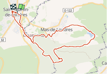
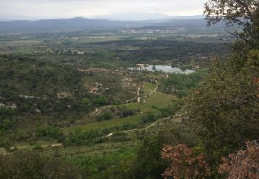
Tour Wandern von 14,4 km verfügbar auf Okzitanien, Hérault, Saint-Martin-de-Londres. Diese Tour wird von v.rabot vorgeschlagen.
Beschreibung
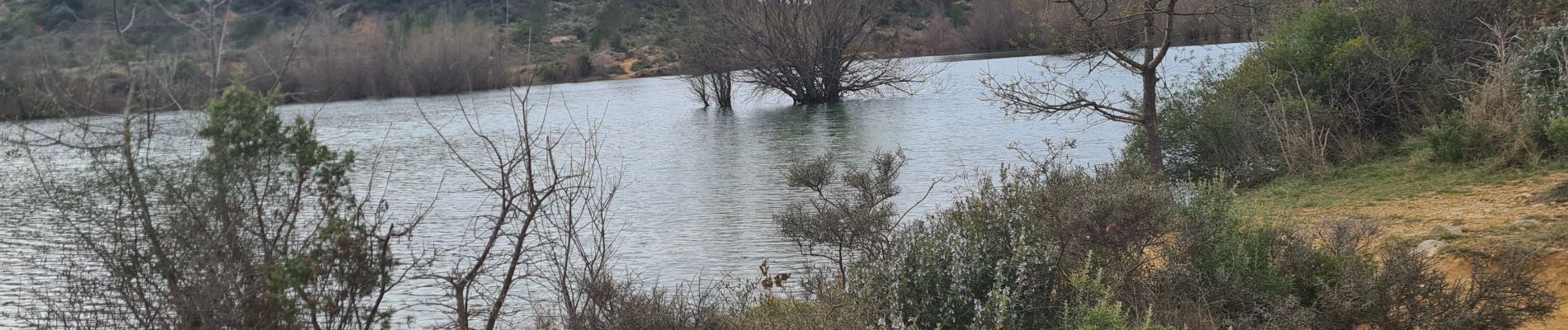
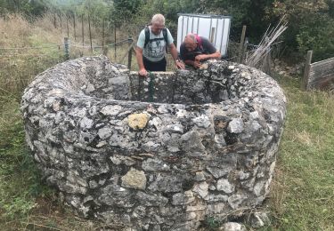
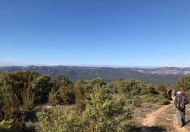
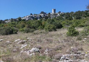
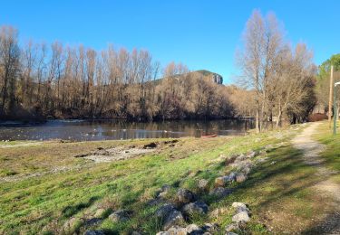
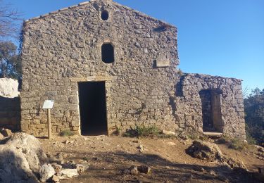
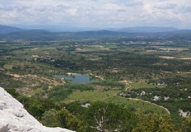
Partant du parking des écoles, on traverse le centre ancien de saint Martin de Londres qui est très joli, l'église dans son écrin mérite le déplacement, elle était ouverte et très simplement décorée. la montée vers les réservoirs n'a aucune difficulté, attention quand on arrive vers le sommets, il y a des petits avens à proximité du chemin. La descente des réservoirs est pleine de cailloux et justifie les batons. Le passage au bord du lac est agréable meme si on n'y voit aucun oiseaux. Il y a beaucoup de puits ou sources le long du parcours, L'église du mas de Londres était fermée, mais très belle extérieurement. Tout le long du parcours on a de belle vues sur la garrigue. Petite randonnée ne présentant aucune difficulté, à ne pas faire en juillet et août.
Ort
Kommentare
Touren in der Umgebung
![Tour Wandern Viols-en-Laval - Fontaine Terou - Photo](https://media.geolcdn.com/t/375/260/893d4ed9-6474-41c2-a5cc-5fad7e67044e.jpg&format=jpg&maxdim=2)
![Wandern Wandern](https://static1.geolcdn.com/sitytour/trail-icons/101.png)
Wandern
![](/images/other/stat-length.png)
![](https://static1.geolcdn.com/siteimages/upload/files/16400158638029165_repeat_loop_refresh_sync_direction_icon.png)
![Tour Wandern Saint-Martin-de-Londres - l'ouradou - Photo](https://media.geolcdn.com/t/375/260/ext.jpg?maxdim=2&url=https%3A%2F%2Fservices.sitytrail.com%2FGeolivesWS%2FDownloadMedia.ashx%3FTrailID%3D860187%26Media%3D20171107114231.jpg)
![Wandern Wandern](https://static1.geolcdn.com/sitytour/trail-icons/101.png)
Wandern
![](/images/other/stat-length.png)
![](https://static1.geolcdn.com/siteimages/upload/files/16400158638029165_repeat_loop_refresh_sync_direction_icon.png)
![Tour Wandern Cazevieille - le tour du pic st loup - Photo](https://media.geolcdn.com/t/375/260/ext.jpg?maxdim=2&url=https%3A%2F%2Fservices.sitytrail.com%2FGeolivesWS%2FDownloadMedia.ashx%3FTrailID%3D564155%26Media%3Dfix__20160505154449.jpg)
![Wandern Wandern](https://static1.geolcdn.com/sitytour/trail-icons/101.png)
Wandern
![](/images/other/stat-length.png)
![](https://static1.geolcdn.com/siteimages/upload/files/16400158638029165_repeat_loop_refresh_sync_direction_icon.png)
![Tour Wandern Mas-de-Londres - 2 Mas de Londres par la Jasse du 18-01-2025 - Photo](https://media.geolcdn.com/t/375/260/192185da-9693-40df-bfdc-9922ac5fb37b.jpg&format=jpg&maxdim=2)
![Wandern Wandern](https://static1.geolcdn.com/sitytour/trail-icons/101.png)
Wandern
![](/images/other/stat-length.png)
![](https://static1.geolcdn.com/siteimages/upload/files/16400158638029165_repeat_loop_refresh_sync_direction_icon.png)
![Tour Wandern Mas-de-Londres - A Mas de Londres à Saint Bauzille de Putois par le GR 60 du 17-01-2025 - Photo](https://media.geolcdn.com/t/375/260/b8a71293-24db-4889-bcb9-e61559e24369.jpg&format=jpg&maxdim=2)
![Wandern Wandern](https://static1.geolcdn.com/sitytour/trail-icons/101.png)
Wandern
![](/images/other/stat-length.png)
![](https://static1.geolcdn.com/siteimages/upload/files/16400158638029165_repeat_loop_refresh_sync_direction_icon.png)
![Tour Wandern Cazevieille - Pic St Loup + Crête 16.12.23 - Photo](https://media.geolcdn.com/t/375/260/bfdaf89a-9773-4f5d-a083-c292c0cb02a4.jpg&format=jpg&maxdim=2)
![Wandern Wandern](https://static1.geolcdn.com/sitytour/trail-icons/101.png)
Wandern
![](/images/other/stat-length.png)
![](https://static1.geolcdn.com/siteimages/upload/files/16400158638029165_repeat_loop_refresh_sync_direction_icon.png)
![Tour Wandern Cazevieille - cazevieille-pic st loup-lac fe la jasse - Photo](https://media.geolcdn.com/t/375/260/ext.jpg?maxdim=2&url=https%3A%2F%2Fservices.sitytrail.com%2FGeolivesWS%2FDownloadMedia.ashx%3FTrailID%3D579300%26Media%3Dfix__20160604134108.jpg)
![Wandern Wandern](https://static1.geolcdn.com/sitytour/trail-icons/101.png)
Wandern
![](/images/other/stat-length.png)
![](https://static1.geolcdn.com/siteimages/upload/files/16400158638029165_repeat_loop_refresh_sync_direction_icon.png)
![Tour Nordic Walking Cazevieille - cazevieille + lac de la jasse - Photo](https://media.geolcdn.com/t/375/260/ext.jpg?maxdim=2&url=https%3A%2F%2Fservices.sitytrail.com%2FGeolivesWS%2FDownloadMedia.ashx%3FTrailID%3D565622%26Media%3Dfix__20160508095919.jpg)
![Nordic Walking Nordic Walking](https://static1.geolcdn.com/sitytour/trail-icons/102.png)
Nordic Walking
![](/images/other/stat-length.png)
![](https://static1.geolcdn.com/siteimages/upload/files/16400158638029165_repeat_loop_refresh_sync_direction_icon.png)
![Tour Wandern Viols-en-Laval - Viols-en-Laval - Cazarils - Montagne de Labat - Paillas - Photo](https://media.geolcdn.com/t/375/260/ext.jpg?maxdim=2&url=https%3A%2F%2Fstatic1.geolcdn.com%2Fsiteimages%2Fupload%2Ffiles%2F1553511878bg_sport_marche.png)
![Wandern Wandern](https://static1.geolcdn.com/sitytour/trail-icons/101.png)
Wandern
![](/images/other/stat-length.png)
![](https://static1.geolcdn.com/siteimages/upload/files/16400158638029165_repeat_loop_refresh_sync_direction_icon.png)