![](/images/other/stat-length.png)
![Tour Wandern Vianden - 2024-02-26_18h54m22_circuit-ourdall-promenade - Photo](https://media.geolcdn.com/t/1900/400/ext.pjpeg?maxdim=2&url=https%3A%2F%2Fstatic1.geolcdn.com%2Fsiteimages%2Fupload%2Ffiles%2F1553511878bg_sport_marche.png)
2024-02-26_18h54m22_circuit-ourdall-promenade
mumu.larandonneuse
Benutzer GUIDE
![Länge](/images/other/stat-length.png)
![Maximale Höhe](https://static1.geolcdn.com/siteimages/upload/files/1508320355ic_sort_altitude_max_24dp.png)
![Positive Höhendifferenz](https://static1.geolcdn.com/siteimages/upload/files/1508320355ic_sort_den_pos_24dp.png)
![Km-Effort](/images/other/stat-length.png)
![Min. Höhe](https://static1.geolcdn.com/siteimages/upload/files/1508320355ic_sort_altitude_min_24dp.png)
![Negative Höhendifferenz](https://static1.geolcdn.com/siteimages/upload/files/1508320355ic_sort_den_neg_24dp.png)
![Boucle](https://static1.geolcdn.com/siteimages/upload/files/16400158638029165_repeat_loop_refresh_sync_direction_icon.png)
![Wandern](https://static1.geolcdn.com/sitytour/trail-icons/101.png)
2h34
Schwierigkeit : Medium
![Scannen Sie diesen QR-Code, um die Tour in der SityTrail-Anwendung zu öffnen](https://capi.geolives.com/qq0zvz2zws4bq2lad0pu/sitytour/trails/3962992/qr.png?size=200)
Kostenlosegpshiking-Anwendung
Über SityTrail
Tour Wandern von 8,8 km verfügbar auf Unbekannt, Kanton Vianden, Vianden. Diese Tour wird von mumu.larandonneuse vorgeschlagen.
Beschreibung
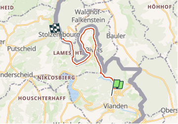
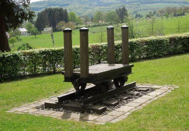
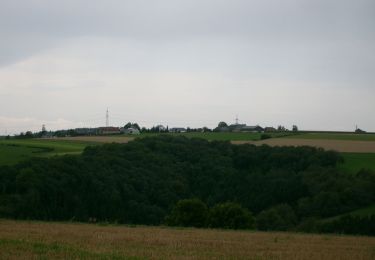
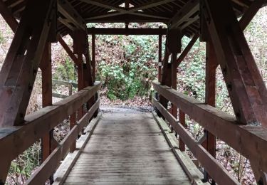
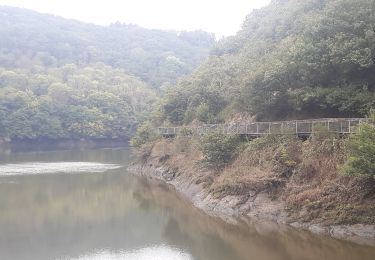
La Promenade de l'Our invite à découvrir la vallée de l'Our entre Vianden et Stolzembourg. En partant de Vianden, vous montez tout de suite une petite colline où vous traversez le barrage de l'Our. Ce chemin très particulier passe en partie par des passerelles en bois qui longent directement la roche. N'oubliez pas de vous retourner pour profiter de la vue sur le château de Vianden et la chapelle Bildchen. Le chemin passe par Bivels jusqu'à Stolzembourg, où vous pouvez prendre le bus pour retourner à Vianden.
ℹ️ www visit-eislek.lu
Ort
Kommentare
Touren in der Umgebung
![Tour Wandern Vianden - Vianden : Télésiège & Château - Photo](https://media.geolcdn.com/t/375/260/d79592ef-5b36-4bc2-ad1d-709da52cc00f.jpg&format=jpg&maxdim=2)
![Wandern Wandern](https://static1.geolcdn.com/sitytour/trail-icons/101.png)
Wandern
![](/images/other/stat-length.png)
![](https://static1.geolcdn.com/siteimages/upload/files/16400158638029165_repeat_loop_refresh_sync_direction_icon.png)
![Tour Wandern Vianden - 2023-06-19_15h21m20_eislek-pad-vianden-1 - Photo](https://media.geolcdn.com/t/375/260/33ae7762-fc23-4c7a-b8ae-83734bad05ea.jpg&format=jpg&maxdim=2)
![Wandern Wandern](https://static1.geolcdn.com/sitytour/trail-icons/101.png)
Wandern
![](/images/other/stat-length.png)
![](https://static1.geolcdn.com/siteimages/upload/files/16400158638029165_repeat_loop_refresh_sync_direction_icon.png)
![Tour Wandern Vianden - Itinérant Luxembourg Jour 7: Vianden -Ettelbruck - Photo](https://media.geolcdn.com/t/375/260/928dee80-2005-4eae-8761-66de6a052544.jpg&format=jpg&maxdim=2)
![Wandern Wandern](https://static1.geolcdn.com/sitytour/trail-icons/101.png)
Wandern
![](/images/other/stat-length.png)
![](https://static1.geolcdn.com/siteimages/upload/files/16400158638029165_repeat_loop_refresh_sync_direction_icon.png)
![Tour Wandern Vianden - Itinérant Luxembourg Jour 6 : Boucle autour de Vianden - Photo](https://media.geolcdn.com/t/375/260/5b9141dd-6e04-4494-b5cf-8eec4ef7e8b3.jpg&format=jpg&maxdim=2)
![Wandern Wandern](https://static1.geolcdn.com/sitytour/trail-icons/101.png)
Wandern
![](/images/other/stat-length.png)
![](https://static1.geolcdn.com/siteimages/upload/files/16400158638029165_repeat_loop_refresh_sync_direction_icon.png)
![Tour Wandern Tandel - 2024-07-11_16h37m44_local-hiking-trail-ta-2 - Photo](https://media.geolcdn.com/t/375/260/8c005037-a9f4-4acb-88bc-4e713f695a2c.jpg&format=jpg&maxdim=2)
![Wandern Wandern](https://static1.geolcdn.com/sitytour/trail-icons/101.png)
Wandern
![](/images/other/stat-length.png)
![](https://static1.geolcdn.com/siteimages/upload/files/16400158638029165_repeat_loop_refresh_sync_direction_icon.png)
![Tour Zu Fuß Vianden - Autopedestre Bettel - Photo](https://media.geolcdn.com/t/375/260/02b2f00a-75a6-48f2-b6f0-c11bc4a34d36.jpeg&format=jpg&maxdim=2)
![Zu Fuß Zu Fuß](https://static1.geolcdn.com/sitytour/trail-icons/100.png)
Zu Fuß
![](/images/other/stat-length.png)
![](https://static1.geolcdn.com/siteimages/upload/files/16400158638029165_repeat_loop_refresh_sync_direction_icon.png)
![Tour Zu Fuß Tandel - Autopedestre Brandenbourg - Photo](https://media.geolcdn.com/t/375/260/f773c6ce-1e62-48fa-9c88-bf2c6a499187.jpeg&format=jpg&maxdim=2)
![Zu Fuß Zu Fuß](https://static1.geolcdn.com/sitytour/trail-icons/100.png)
Zu Fuß
![](/images/other/stat-length.png)
![](https://static1.geolcdn.com/siteimages/upload/files/16400158638029165_repeat_loop_refresh_sync_direction_icon.png)
![Tour Wandern Vianden - Les panoramas de Vianden - Photo](https://media.geolcdn.com/t/375/260/eea14bf8-62f0-4367-9ed4-8f55cee74d56.jpg&format=jpg&maxdim=2)
![Wandern Wandern](https://static1.geolcdn.com/sitytour/trail-icons/101.png)
Wandern
![](/images/other/stat-length.png)
![](https://static1.geolcdn.com/siteimages/upload/files/16400158638029165_repeat_loop_refresh_sync_direction_icon.png)
![Tour Wandern Vianden - vianden . stolzemmbour - Photo](https://media.geolcdn.com/t/375/260/04cc6bc0-b9f3-4b97-a33c-e613e3b69f69.jpg&format=jpg&maxdim=2)
![Wandern Wandern](https://static1.geolcdn.com/sitytour/trail-icons/101.png)
Wandern
![](/images/other/stat-length.png)
![](https://static1.geolcdn.com/siteimages/upload/files/16400158638029165_repeat_loop_refresh_sync_direction_icon.png)