![](/images/other/stat-length.png)
![Tour Wandern Pont de Montvert - Sud Mont Lozère - Stevenson - Etape 10 - Photo](https://media.geolcdn.com/t/1900/400/ext.pjpeg?maxdim=2&url=https%3A%2F%2Fstatic1.geolcdn.com%2Fsiteimages%2Fupload%2Ffiles%2F1553511878bg_sport_marche.png)
Stevenson - Etape 10
nfranche
Benutzer
![Länge](/images/other/stat-length.png)
![Maximale Höhe](https://static1.geolcdn.com/siteimages/upload/files/1508320355ic_sort_altitude_max_24dp.png)
![Positive Höhendifferenz](https://static1.geolcdn.com/siteimages/upload/files/1508320355ic_sort_den_pos_24dp.png)
![Km-Effort](/images/other/stat-length.png)
![Min. Höhe](https://static1.geolcdn.com/siteimages/upload/files/1508320355ic_sort_altitude_min_24dp.png)
![Negative Höhendifferenz](https://static1.geolcdn.com/siteimages/upload/files/1508320355ic_sort_den_neg_24dp.png)
![Boucle](https://static1.geolcdn.com/siteimages/upload/files/16400158638029165_repeat_loop_refresh_sync_direction_icon.png)
![Wandern](https://static1.geolcdn.com/sitytour/trail-icons/101.png)
8h28
Schwierigkeit : Medium
![Scannen Sie diesen QR-Code, um die Tour in der SityTrail-Anwendung zu öffnen](https://capi.geolives.com/qq0zvz2zws4bq2lad0pu/sitytour/trails/395794/qr.png?size=200)
Kostenlosegpshiking-Anwendung
Über SityTrail
Tour Wandern von 29 km verfügbar auf Okzitanien, Lozère, Pont de Montvert - Sud Mont Lozère. Diese Tour wird von nfranche vorgeschlagen.
Beschreibung
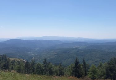
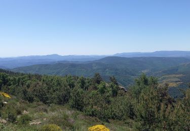
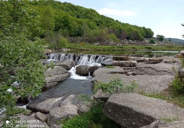
Pont-de-Montvert - Florac : Bien qu'un peu difficile par son dénivelé associé à un kilométrage important, c'est sans conteste une des plus belles étapes de ce trek. Quasiment aucun bitume, particulièrement fleurie avec des haies et des champs de genêts très embaumants, des champs de narcises, des tulipes sauvages, une vue époustouflante au Signal de Bougès
Ort
Kommentare
Touren in der Umgebung
![Tour Wandern Pont de Montvert - Sud Mont Lozère - Montagne du Bougès - Photo](https://media.geolcdn.com/t/375/260/0f70d5f6-b995-4149-890f-c1b536613d08.jpg&format=jpg&maxdim=2)
![Wandern Wandern](https://static1.geolcdn.com/sitytour/trail-icons/101.png)
Wandern
![](/images/other/stat-length.png)
![](https://static1.geolcdn.com/siteimages/upload/files/16400158638029165_repeat_loop_refresh_sync_direction_icon.png)
![Tour Wandern Pont de Montvert - Sud Mont Lozère - Bédoues saint jean du Gard GR70 gr43 - Photo](https://media.geolcdn.com/t/375/260/c8a87bd6-9939-4680-8373-9b7fd4cfe94c.jpg&format=jpg&maxdim=2)
![Wandern Wandern](https://static1.geolcdn.com/sitytour/trail-icons/101.png)
Wandern
![](/images/other/stat-length.png)
![](https://static1.geolcdn.com/siteimages/upload/files/16400158638029165_repeat_loop_refresh_sync_direction_icon.png)
![Tour Wandern Pont de Montvert - Sud Mont Lozère - Stevenson pont de Monvert/ Bedouès - Photo](https://media.geolcdn.com/t/375/260/ecbe7c42-7ae5-463d-8ef8-0e93073f446d.jpg&format=jpg&maxdim=2)
![Wandern Wandern](https://static1.geolcdn.com/sitytour/trail-icons/101.png)
Wandern
![](/images/other/stat-length.png)
![](https://static1.geolcdn.com/siteimages/upload/files/16400158638029165_repeat_loop_refresh_sync_direction_icon.png)
![Tour Wandern Pont de Montvert - Sud Mont Lozère - 13-05-2023 E8 Le Pont de Monvers - Bédouès - Photo](https://media.geolcdn.com/t/375/260/e57cdaa9-bdeb-4cef-90ee-76cf38da3fbe.jpg&format=jpg&maxdim=2)
![Wandern Wandern](https://static1.geolcdn.com/sitytour/trail-icons/101.png)
Wandern
![](/images/other/stat-length.png)
![](https://static1.geolcdn.com/siteimages/upload/files/16400158638029165_repeat_loop_refresh_sync_direction_icon.png)
![Tour Wandern Pont de Montvert - Sud Mont Lozère - Finiels/ sommet / station du Bleymard en boucle - Photo](https://media.geolcdn.com/t/375/260/f8048304-3a05-4fd0-a0e7-03457722fcee.jpg&format=jpg&maxdim=2)
![Wandern Wandern](https://static1.geolcdn.com/sitytour/trail-icons/101.png)
Wandern
![](/images/other/stat-length.png)
![](https://static1.geolcdn.com/siteimages/upload/files/16400158638029165_repeat_loop_refresh_sync_direction_icon.png)
![Tour Wandern Pont de Montvert - Sud Mont Lozère - Signal du Ventalon - Photo](https://media.geolcdn.com/t/375/260/7301b799-eab0-43e1-a503-e72b81bfeb12.jpg&format=jpg&maxdim=2)
![Wandern Wandern](https://static1.geolcdn.com/sitytour/trail-icons/101.png)
Wandern
![](/images/other/stat-length.png)
![](https://static1.geolcdn.com/siteimages/upload/files/16400158638029165_repeat_loop_refresh_sync_direction_icon.png)
![Tour Wandern Pont de Montvert - Sud Mont Lozère - J6 Stevenson: Pont de Monvert - Cassagnas - Photo](https://media.geolcdn.com/t/375/260/ext.jpg?maxdim=2&url=https%3A%2F%2Fstatic1.geolcdn.com%2Fsiteimages%2Fupload%2Ffiles%2F1553511878bg_sport_marche.png)
![Wandern Wandern](https://static1.geolcdn.com/sitytour/trail-icons/101.png)
Wandern
![](/images/other/stat-length.png)
![](https://static1.geolcdn.com/siteimages/upload/files/16400158638029165_repeat_loop_refresh_sync_direction_icon.png)
![Tour Wandern Pont de Montvert - Sud Mont Lozère - 30 pont Tarn 6 /5/24 - Photo](https://media.geolcdn.com/t/375/260/7d800b0f-50cc-4008-98c4-8c5492592e92.jpg&format=jpg&maxdim=2)
![Wandern Wandern](https://static1.geolcdn.com/sitytour/trail-icons/101.png)
Wandern
![](/images/other/stat-length.png)
![](https://static1.geolcdn.com/siteimages/upload/files/16400158638029165_repeat_loop_refresh_sync_direction_icon.png)
![Zu Fuß Zu Fuß](https://static1.geolcdn.com/sitytour/trail-icons/100.png)
Zu Fuß
![](/images/other/stat-length.png)
![](https://static1.geolcdn.com/siteimages/upload/files/16400158638029165_repeat_loop_refresh_sync_direction_icon.png)