![](/images/other/stat-length.png)
![Tour Wandern Flayosc - Tracé actuel: 18 FEV 2024 12:49 - Photo](https://media.geolcdn.com/t/1900/400/ext.pjpeg?maxdim=2&url=https%3A%2F%2Fstatic1.geolcdn.com%2Fsiteimages%2Fupload%2Ffiles%2F1553511878bg_sport_marche.png)
Tracé actuel: 18 FEV 2024 12:49
felix83
Benutzer
![Länge](/images/other/stat-length.png)
![Maximale Höhe](https://static1.geolcdn.com/siteimages/upload/files/1508320355ic_sort_altitude_max_24dp.png)
![Positive Höhendifferenz](https://static1.geolcdn.com/siteimages/upload/files/1508320355ic_sort_den_pos_24dp.png)
![Km-Effort](/images/other/stat-length.png)
![Min. Höhe](https://static1.geolcdn.com/siteimages/upload/files/1508320355ic_sort_altitude_min_24dp.png)
![Negative Höhendifferenz](https://static1.geolcdn.com/siteimages/upload/files/1508320355ic_sort_den_neg_24dp.png)
![Boucle](https://static1.geolcdn.com/siteimages/upload/files/16400158638029165_repeat_loop_refresh_sync_direction_icon.png)
![Wandern](https://static1.geolcdn.com/sitytour/trail-icons/101.png)
2h15
Schwierigkeit : Medium
![Scannen Sie diesen QR-Code, um die Tour in der SityTrail-Anwendung zu öffnen](https://capi.geolives.com/qq0zvz2zws4bq2lad0pu/sitytour/trails/3954601/qr.png?size=200)
Kostenlosegpshiking-Anwendung
Über SityTrail
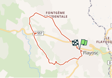
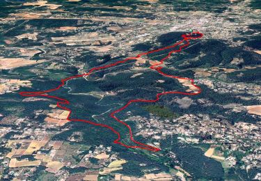
Tour Wandern von 8 km verfügbar auf Provence-Alpes-Côte d'Azur, Var, Flayosc. Diese Tour wird von felix83 vorgeschlagen.
Beschreibung
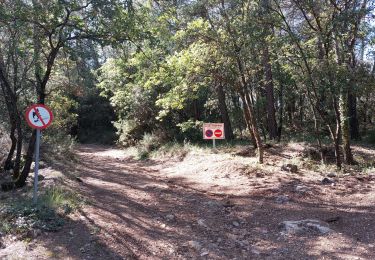
Aucune difficulté. Penser à longer le canal au début pour éviter de marcher le long de la route départementale. Les montées sont à la fin. Attention si vous avez un groupe car il faudra traverser la D557. C'est quasiment en haut d'une côte donc soyez prudents.
Stationnement des voitures sur le grand parking en haut de Flayosc. Il est sur 2 niveaux donc peut accueillir un dizaine de voitures
Ort
Kommentare
Touren in der Umgebung
![Tour Wandern Flayosc - Flayosc - Photo](https://media.geolcdn.com/t/375/260/ext.jpg?maxdim=2&url=https%3A%2F%2Fstatic1.geolcdn.com%2Fsiteimages%2Fupload%2Ffiles%2F1553511878bg_sport_marche.png)
![Wandern Wandern](https://static1.geolcdn.com/sitytour/trail-icons/101.png)
Wandern
![](/images/other/stat-length.png)
![](https://static1.geolcdn.com/siteimages/upload/files/16400158638029165_repeat_loop_refresh_sync_direction_icon.png)
![Tour Wandern Lorgues - SityTrail - Le hameau de Sauveclare - Photo](https://media.geolcdn.com/t/375/260/bc0b058e-af96-4d28-bc15-d4c1c9d787b7.jpg&format=jpg&maxdim=2)
![Wandern Wandern](https://static1.geolcdn.com/sitytour/trail-icons/101.png)
Wandern
![](/images/other/stat-length.png)
![](https://static1.geolcdn.com/siteimages/upload/files/16400158638029165_repeat_loop_refresh_sync_direction_icon.png)
![Tour Wandern Lorgues - Lorgues et l'Ermitage Saint-Ferréol - Photo](https://media.geolcdn.com/t/375/260/e62c5b83-8a2e-4772-82d8-7fdc4c20c935.jpg&format=jpg&maxdim=2)
![Wandern Wandern](https://static1.geolcdn.com/sitytour/trail-icons/101.png)
Wandern
![](/images/other/stat-length.png)
![](https://static1.geolcdn.com/siteimages/upload/files/16400158638029165_repeat_loop_refresh_sync_direction_icon.png)
![Tour Wandern Draguignan - Rebouillon le long de la Nartuby - Photo](https://media.geolcdn.com/t/375/260/5546167f-335f-4958-9f3e-7305fd054196.jpg&format=jpg&maxdim=2)
![Wandern Wandern](https://static1.geolcdn.com/sitytour/trail-icons/101.png)
Wandern
![](/images/other/stat-length.png)
![](https://static1.geolcdn.com/siteimages/upload/files/16400158638029165_repeat_loop_refresh_sync_direction_icon.png)
![Wandern Wandern](https://static1.geolcdn.com/sitytour/trail-icons/101.png)
Wandern
![](/images/other/stat-length.png)
![](https://static1.geolcdn.com/siteimages/upload/files/16400158638029165_repeat_loop_refresh_sync_direction_icon.png)
![Tour Wandern Flayosc - 20210922 Berne3 les Oussiayes - Photo](https://media.geolcdn.com/t/375/260/63a967ae-524a-431f-b327-781a014fa426.jpg&format=jpg&maxdim=2)
![Wandern Wandern](https://static1.geolcdn.com/sitytour/trail-icons/101.png)
Wandern
![](/images/other/stat-length.png)
![](https://static1.geolcdn.com/siteimages/upload/files/16400158638029165_repeat_loop_refresh_sync_direction_icon.png)
![Tour Rennrad Draguignan - la clape - Photo](https://media.geolcdn.com/t/375/260/0765a432-74ac-42bd-825e-91e99e328dea.jpg&format=jpg&maxdim=2)
![Rennrad Rennrad](https://static1.geolcdn.com/sitytour/trail-icons/201.png)
Rennrad
![](/images/other/stat-length.png)
![](https://static1.geolcdn.com/siteimages/upload/files/16400158638029165_repeat_loop_refresh_sync_direction_icon.png)
![Tour Wandern Lorgues - Lorgues - sentier découverte Saint-Ferréol - Photo](https://media.geolcdn.com/t/375/260/45684484-d312-4a9e-82bd-16f54a0668a9.jpg&format=jpg&maxdim=2)
![Wandern Wandern](https://static1.geolcdn.com/sitytour/trail-icons/101.png)
Wandern
![](/images/other/stat-length.png)
![](https://static1.geolcdn.com/siteimages/upload/files/16400158638029165_repeat_loop_refresh_sync_direction_icon.png)
![Tour Wandern Flayosc -](https://media.geolcdn.com/t/375/260/83c7696e-952a-48f5-bea9-fa5ceec23ba1.jpg&format=jpg&maxdim=2)
![Wandern Wandern](https://static1.geolcdn.com/sitytour/trail-icons/101.png)
Wandern
![](/images/other/stat-length.png)
![](https://static1.geolcdn.com/siteimages/upload/files/16400158638029165_repeat_loop_refresh_sync_direction_icon.png)