![](/images/other/stat-length.png)
![Tour Wandern Mortagne-au-Perche - [Itinéraire] Le Pissot, par monts et par vaux - Photo](https://media.geolcdn.com/t/1900/400/ext.pjpeg?maxdim=2&url=https%3A%2F%2Fstatic1.geolcdn.com%2Fsiteimages%2Fupload%2Ffiles%2F1553511878bg_sport_marche.png)
[Itinéraire] Le Pissot, par monts et par vaux
ODDAD78
Benutzer
![Länge](/images/other/stat-length.png)
![Maximale Höhe](https://static1.geolcdn.com/siteimages/upload/files/1508320355ic_sort_altitude_max_24dp.png)
![Positive Höhendifferenz](https://static1.geolcdn.com/siteimages/upload/files/1508320355ic_sort_den_pos_24dp.png)
![Km-Effort](/images/other/stat-length.png)
![Min. Höhe](https://static1.geolcdn.com/siteimages/upload/files/1508320355ic_sort_altitude_min_24dp.png)
![Negative Höhendifferenz](https://static1.geolcdn.com/siteimages/upload/files/1508320355ic_sort_den_neg_24dp.png)
![Boucle](https://static1.geolcdn.com/siteimages/upload/files/16400158638029165_repeat_loop_refresh_sync_direction_icon.png)
![Wandern](https://static1.geolcdn.com/sitytour/trail-icons/101.png)
1h54
Schwierigkeit : Medium
![Scannen Sie diesen QR-Code, um die Tour in der SityTrail-Anwendung zu öffnen](https://capi.geolives.com/qq0zvz2zws4bq2lad0pu/sitytour/trails/3944633/qr.png?size=200)
Kostenlosegpshiking-Anwendung
Über SityTrail
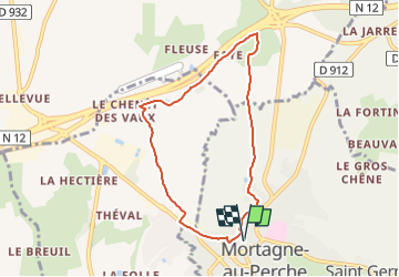
Tour Wandern von 6,8 km verfügbar auf Normandie, Orne, Mortagne-au-Perche. Diese Tour wird von ODDAD78 vorgeschlagen.
Beschreibung
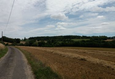
En quittant le centre-ville, vous découvrirez un premier site de l’ancienne tannerie de Mortagne- au-Perche au Pissot, le long de la Chippe, et vous rejoindrez un chemin de terre. Tout au long de ce chemin il sera opportun de se retourner régulièrement pour découvrir des points de vue sur la ville de Mortagne-au-Perche. Vous pourrez également observer les essences locales : chêne, frêne, hêtre, sureau, aubépine (au lieu-dit Faye). En contre bas, un ancien fournil s’observe avec son toit à quatre pans. En continuant jusqu’au manoir du Chenêt des Vaux (manoir privé) pour revenir vers Mortagne-au-Perche, vous aurez une vue imprenable sur les anciens remparts et ses faubourgs.
Départ vers les faubourgs de Mortagne-au-Perche, puis découverte de vues panoramiques sur la ville en passant par un ancien séchoir à peaux.
Pas à pas (Rando-Perche)
Départ : Mortagne-au-Perche, place du tribunal Arrivée : Mortagne-au-Perche, place du tribunal Communes : 1. Mortagne-au-Perche
2. Saint-Hilaire-le-Châtel
3. Saint-Langis-lès-Mortagne
Départ de la place du Tribunal
1. Remonter la place et prendre à droite la rue de Toussaint
2. Rejoindre la Place aux Cerfs en traversant la rue des Tailles.
3. Emprunter la rue de Rouen et descendre à gauche rue du Tertre.
4. En bas de la rue du Tertre, prendre la route à gauche et tout de suite à droite le chemin de
terre Passage du Pissot (entre 2 chicanes de bois)
5. Au bout du passage du Pissot, prendre à droite et continuer toujours tout droit sur le chemin de
terre jusqu’au lieu dit Bas Faye
6. Au calvaire de la Maison Neuve, prendre à gauche et poursuivre jusqu’au lieu-dit Le Chenêt des
Vaux
7. Juste avant le manoir du Le Chenêt des Vaux, prendre à gauche le chemin de terre qui descend
8. Tout au bout du chemin, prendre à droite pour remonter vers le Faubourg Saint Eloi
9. Arrivés au Faubourg Saint Eloi, tourner à gauche pour revenir vers le centre-ville
10. Passer devant le garage Elan et descendre la rue de Rouen
11. Arrivé au numéro 17 de la rue de Rouen, prendre la rue Quinconce à droite, en laissant l’ancien
Presbytère dans son dos, puis continuer rue Pierre Boucher
12. Au numéro 6 de la rue Pierre Boucher, prendre à gauche rue du Jardinet
13. Poursuivre par la ruelle pavée du Vert galant
14. Passé le porche, prendre à droite rue de Toussaint pour remonter au point de départ, place du
Tribunal
Ort
Kommentare
Touren in der Umgebung
![Tour Wandern Mortagne-au-Perche - SityTrail - La Chapelle-Montligeon - Mortagne-au-Perche 14 km - Photo](https://media.geolcdn.com/t/375/260/ff6e4fe8-c15c-4360-a70d-10a6e0124b39.jpg&format=jpg&maxdim=2)
![Wandern Wandern](https://static1.geolcdn.com/sitytour/trail-icons/101.png)
Wandern
![](/images/other/stat-length.png)
![](https://static1.geolcdn.com/siteimages/upload/files/16400158638029165_repeat_loop_refresh_sync_direction_icon.png)
![Tour Wandern Mortagne-au-Perche - Longny-au-Perche (Longny-les-Villages) - Mortagne-au-Perche 22 km - Photo](https://media.geolcdn.com/t/375/260/dc147254-135f-4ef9-ba9f-78ed99896307.jpg&format=jpg&maxdim=2)
![Wandern Wandern](https://static1.geolcdn.com/sitytour/trail-icons/101.png)
Wandern
![](/images/other/stat-length.png)
![](https://static1.geolcdn.com/siteimages/upload/files/16400158638029165_repeat_loop_refresh_sync_direction_icon.png)
![Tour Wandern Mortagne-au-Perche - Mortagne-au-Perche - Tourouvre (TCP) 25 km - Photo](https://media.geolcdn.com/t/375/260/30ae83c9-f490-41c7-a951-fa85f4916e7d.jpg&format=jpg&maxdim=2)
![Wandern Wandern](https://static1.geolcdn.com/sitytour/trail-icons/101.png)
Wandern
![](/images/other/stat-length.png)
![](https://static1.geolcdn.com/siteimages/upload/files/16400158638029165_repeat_loop_refresh_sync_direction_icon.png)
![Tour Elektrofahrrad Saint-Langis-lès-Mortagne - boucle a partir de Mortagne - Photo](https://media.geolcdn.com/t/375/260/3cc9d3e3-289a-416e-819d-7f0b7d16b696.jpg&format=jpg&maxdim=2)
![Elektrofahrrad Elektrofahrrad](https://static1.geolcdn.com/sitytour/trail-icons/205.png)
Elektrofahrrad
![](/images/other/stat-length.png)
![](https://static1.geolcdn.com/siteimages/upload/files/16400158638029165_repeat_loop_refresh_sync_direction_icon.png)
![Tour Wandern Saint-Langis-lès-Mortagne - A la découverte de la Grosse Fontaine 7,9km - Photo](https://media.geolcdn.com/t/375/260/ext.jpg?maxdim=2&url=https%3A%2F%2Fstatic1.geolcdn.com%2Fsiteimages%2Fupload%2Ffiles%2F1553511878bg_sport_marche.png)
![Wandern Wandern](https://static1.geolcdn.com/sitytour/trail-icons/101.png)
Wandern
![](/images/other/stat-length.png)
![](https://static1.geolcdn.com/siteimages/upload/files/16400158638029165_repeat_loop_refresh_sync_direction_icon.png)
![Tour Wandern Saint-Langis-lès-Mortagne - [Itinéraire] A la Découverte de la Source de Grosse Fontaine - Photo](https://media.geolcdn.com/t/375/260/ext.jpg?maxdim=2&url=https%3A%2F%2Fstatic1.geolcdn.com%2Fsiteimages%2Fupload%2Ffiles%2F1553511878bg_sport_marche.png)
![Wandern Wandern](https://static1.geolcdn.com/sitytour/trail-icons/101.png)
Wandern
![](/images/other/stat-length.png)
![](https://static1.geolcdn.com/siteimages/upload/files/16400158638029165_repeat_loop_refresh_sync_direction_icon.png)
![Tour Wandern Mortagne-au-Perche - [Itinéraire] Au temps des remparts - Photo](https://media.geolcdn.com/t/375/260/ext.jpg?maxdim=2&url=https%3A%2F%2Fstatic1.geolcdn.com%2Fsiteimages%2Fupload%2Ffiles%2F1553511878bg_sport_marche.png)
![Wandern Wandern](https://static1.geolcdn.com/sitytour/trail-icons/101.png)
Wandern
![](/images/other/stat-length.png)
![](https://static1.geolcdn.com/siteimages/upload/files/16400158638029165_repeat_loop_refresh_sync_direction_icon.png)
![Tour Wandern Mortagne-au-Perche - [Itinéraire] Au fil du temps - Photo](https://media.geolcdn.com/t/375/260/ext.jpg?maxdim=2&url=https%3A%2F%2Fstatic1.geolcdn.com%2Fsiteimages%2Fupload%2Ffiles%2F1553511878bg_sport_marche.png)
![Wandern Wandern](https://static1.geolcdn.com/sitytour/trail-icons/101.png)
Wandern
![](/images/other/stat-length.png)
![](https://static1.geolcdn.com/siteimages/upload/files/16400158638029165_repeat_loop_refresh_sync_direction_icon.png)
![Tour Wandern Mortagne-au-Perche - Mortagne au Perche - Photo](https://media.geolcdn.com/t/375/260/ext.jpg?maxdim=2&url=https%3A%2F%2Fstatic1.geolcdn.com%2Fsiteimages%2Fupload%2Ffiles%2F1553511878bg_sport_marche.png)
![Wandern Wandern](https://static1.geolcdn.com/sitytour/trail-icons/101.png)
Wandern
![](/images/other/stat-length.png)
![](https://static1.geolcdn.com/siteimages/upload/files/16400158638029165_repeat_loop_refresh_sync_direction_icon.png)