![](/images/other/stat-length.png)
![Tour Wandern Saint-Agnant - Le long du canal de St Agnant à Echillais - Photo](https://media.geolcdn.com/t/1900/400/ext.pjpeg?maxdim=2&url=https%3A%2F%2Fservices.sitytrail.com%2FGeolivesWS%2FDownloadMedia.ashx%3FTrailID%3D393716%26Media%3Dfix__20150308163106.jpg)
Le long du canal de St Agnant à Echillais
Bobol
Benutzer
![Länge](/images/other/stat-length.png)
Länge
9,9 km
![Maximale Höhe](https://static1.geolcdn.com/siteimages/upload/files/1508320355ic_sort_altitude_max_24dp.png)
Maximale Höhe
9 m
![Positive Höhendifferenz](https://static1.geolcdn.com/siteimages/upload/files/1508320355ic_sort_den_pos_24dp.png)
Positive Höhendifferenz
36 m
![Km-Effort](/images/other/stat-length.png)
Km-Effort
10,3 km
![Min. Höhe](https://static1.geolcdn.com/siteimages/upload/files/1508320355ic_sort_altitude_min_24dp.png)
Min. Höhe
-1 m
![Negative Höhendifferenz](https://static1.geolcdn.com/siteimages/upload/files/1508320355ic_sort_den_neg_24dp.png)
Negative Höhendifferenz
36 m
![Boucle](https://static1.geolcdn.com/siteimages/upload/files/16400158638029165_repeat_loop_refresh_sync_direction_icon.png)
Boucle
Ja
Erstellungsdatum :
2015-03-08 00:00:00.0
Letzte Änderung :
2015-03-08 00:00:00.0
![Wandern](https://static1.geolcdn.com/sitytour/trail-icons/101.png)
2h06
Schwierigkeit : Einfach
![Scannen Sie diesen QR-Code, um die Tour in der SityTrail-Anwendung zu öffnen](https://capi.geolives.com/qq0zvz2zws4bq2lad0pu/sitytour/trails/393716/qr.png?size=200)
Kostenlosegpshiking-Anwendung
Über SityTrail
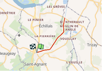
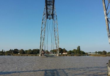
Tour Wandern von 9,9 km verfügbar auf Neu-Aquitanien, Charente-Maritime, Saint-Agnant. Diese Tour wird von Bobol vorgeschlagen.
Beschreibung
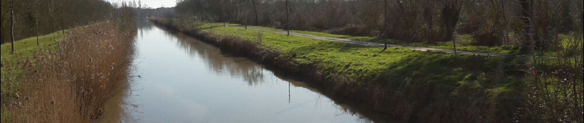
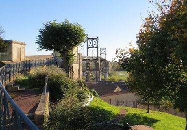
Petite rando sympa le long du canal en aller et retour. Attention au chemin si le temps était à la pluie les derniers jours.
Ort
Land:
France
Region :
Neu-Aquitanien
Abteilung/Provinz :
Charente-Maritime
Kommune :
Saint-Agnant
Standort:
Unknown
Gehen Sie:(Dec)
Gehen Sie:(UTM)
658077 ; 5082225 (30T) N.
Kommentare
Touren in der Umgebung
![Tour Fahrrad Rochefort - Les ponts rochefortais - Rochefort - Photo](https://media.geolcdn.com/t/375/260/ext.jpg?maxdim=2&url=https%3A%2F%2Fservices.sitytrail.com%2FGeolivesWS%2FDownloadMedia.ashx%3FTrailID%3D172941%26Media%3D14418_2.jpg)
![Fahrrad Fahrrad](https://static1.geolcdn.com/sitytour/trail-icons/200.png)
Les ponts rochefortais - Rochefort
Fahrrad
Medium
(1)
Rochefort,
Neu-Aquitanien,
Charente-Maritime,
France
![](/images/other/stat-length.png)
28 km | 30 km-effort
3h 0min
![](https://static1.geolcdn.com/siteimages/upload/files/16400158638029165_repeat_loop_refresh_sync_direction_icon.png)
Ja
![Tour Wandern Marennes-Hiers-Brouage - MAIRAIS ST AIGNANT 17 - Photo](https://media.geolcdn.com/t/375/260/ext.jpg?maxdim=2&url=https%3A%2F%2Fservices.sitytrail.com%2FGeolivesWS%2FDownloadMedia.ashx%3FTrailID%3D1013028%26Media%3Dfix__20180730104520.jpg)
![Wandern Wandern](https://static1.geolcdn.com/sitytour/trail-icons/101.png)
MAIRAIS ST AIGNANT 17
Wandern
Sehr leicht
Marennes-Hiers-Brouage,
Neu-Aquitanien,
Charente-Maritime,
France
![](/images/other/stat-length.png)
5,8 km | 5,9 km-effort
1h 20min
![](https://static1.geolcdn.com/siteimages/upload/files/16400158638029165_repeat_loop_refresh_sync_direction_icon.png)
Ja
![Tour Wandern Rochefort - Rochefort - Photo](https://media.geolcdn.com/t/375/260/ext.jpg?maxdim=2&url=https%3A%2F%2Fservices.sitytrail.com%2FGeolivesWS%2FDownloadMedia.ashx%3FTrailID%3D476372%26Media%3Dfix__20150927173006.jpg)
![Wandern Wandern](https://static1.geolcdn.com/sitytour/trail-icons/101.png)
Rochefort
Wandern
Einfach
(1)
Rochefort,
Neu-Aquitanien,
Charente-Maritime,
France
![](/images/other/stat-length.png)
10,7 km | 11,7 km-effort
2h 53min
![](https://static1.geolcdn.com/siteimages/upload/files/16400158638029165_repeat_loop_refresh_sync_direction_icon.png)
Ja
![Tour Wandern Saint-Agnant - st Aignant - Photo](https://media.geolcdn.com/t/375/260/559ba164-fbec-4179-a895-1ba86c48de4b.jpg&format=jpg&maxdim=2)
![Wandern Wandern](https://static1.geolcdn.com/sitytour/trail-icons/101.png)
st Aignant
Wandern
Sehr leicht
Saint-Agnant,
Neu-Aquitanien,
Charente-Maritime,
France
![](/images/other/stat-length.png)
12,7 km | 13,7 km-effort
4h 23min
![](https://static1.geolcdn.com/siteimages/upload/files/16400158638029165_repeat_loop_refresh_sync_direction_icon.png)
Ja
![Tour Mountainbike Rochefort - Les ponts rochefortais - Rochefort - Photo](https://media.geolcdn.com/t/375/260/ext.jpg?maxdim=2&url=https%3A%2F%2Fservices.sitytrail.com%2FGeolivesWS%2FDownloadMedia.ashx%3FTrailID%3D172940%26Media%3D14418_2.jpg)
![Mountainbike Mountainbike](https://static1.geolcdn.com/sitytour/trail-icons/202.png)
Les ponts rochefortais - Rochefort
Mountainbike
Medium
Rochefort,
Neu-Aquitanien,
Charente-Maritime,
France
![](/images/other/stat-length.png)
28 km | 30 km-effort
2h 30min
![](https://static1.geolcdn.com/siteimages/upload/files/16400158638029165_repeat_loop_refresh_sync_direction_icon.png)
Ja
![Tour Wandern Rochefort - Les ponts rochefortais - Rochefort - Photo](https://media.geolcdn.com/t/375/260/ext.jpg?maxdim=2&url=https%3A%2F%2Fservices.sitytrail.com%2FGeolivesWS%2FDownloadMedia.ashx%3FTrailID%3D172939%26Media%3D14418_2.jpg)
![Wandern Wandern](https://static1.geolcdn.com/sitytour/trail-icons/101.png)
Les ponts rochefortais - Rochefort
Wandern
Schwierig
Rochefort,
Neu-Aquitanien,
Charente-Maritime,
France
![](/images/other/stat-length.png)
28 km | 30 km-effort
5h 0min
![](https://static1.geolcdn.com/siteimages/upload/files/16400158638029165_repeat_loop_refresh_sync_direction_icon.png)
Ja
![Tour Wandern Trizay - Randonnée 10kms Trizay - Photo](https://media.geolcdn.com/t/375/260/093bb969-feaa-474d-b124-997e57608bbe.jpg&format=jpg&maxdim=2)
![Wandern Wandern](https://static1.geolcdn.com/sitytour/trail-icons/101.png)
Randonnée 10kms Trizay
Wandern
Einfach
Trizay,
Neu-Aquitanien,
Charente-Maritime,
France
![](/images/other/stat-length.png)
10,3 km | 11,1 km-effort
2h 52min
![](https://static1.geolcdn.com/siteimages/upload/files/16400158638029165_repeat_loop_refresh_sync_direction_icon.png)
Ja
![Tour Wandern Champagne - CHAMPAGNE NORD 10km - Photo](https://media.geolcdn.com/t/375/260/ext.jpg?maxdim=2&url=https%3A%2F%2Fstatic1.geolcdn.com%2Fsiteimages%2Fupload%2Ffiles%2F1553511878bg_sport_marche.png)
![Wandern Wandern](https://static1.geolcdn.com/sitytour/trail-icons/101.png)
CHAMPAGNE NORD 10km
Wandern
Medium
(1)
Champagne,
Neu-Aquitanien,
Charente-Maritime,
France
![](/images/other/stat-length.png)
10 km | 11,3 km-effort
2h 29min
![](https://static1.geolcdn.com/siteimages/upload/files/16400158638029165_repeat_loop_refresh_sync_direction_icon.png)
Ja
![Tour Wandern Échillais - ba 721 ouest - Photo](https://media.geolcdn.com/t/375/260/ext.jpg?maxdim=2&url=https%3A%2F%2Fstatic1.geolcdn.com%2Fsiteimages%2Fupload%2Ffiles%2F1553511878bg_sport_marche.png)
![Wandern Wandern](https://static1.geolcdn.com/sitytour/trail-icons/101.png)
ba 721 ouest
Wandern
Medium
Échillais,
Neu-Aquitanien,
Charente-Maritime,
France
![](/images/other/stat-length.png)
16,5 km | 17,7 km-effort
3h 2min
![](https://static1.geolcdn.com/siteimages/upload/files/16400158638029165_repeat_loop_refresh_sync_direction_icon.png)
Ja